Mount Vernon is a neighborhood immediately north of downtown Baltimore, Maryland. Designated a National Historic Landmark District and a city Cultural District, it is one of the city's oldest neighborhoods and originally was home to the city's most wealthy and fashionable families. The name derives from the Mount Vernon home of George Washington; the original Washington Monument, a massive pillar commenced in 1815 to commemorate the first president of the United States, is the defining feature of the neighborhood.

The Daniel Marrett House is a historic house museum at 40 East Ossippee Trail in Standish, Maine. Built in 1789, it is a prominent local example of Greek Revival architecture, and was for many years owned by members of the Marrett family. In 1944 it was given to the Society for the Preservation of New England Antiquities, which operates it as a museum today. The house was listed on the National Register of Historic Places in 1974.
Washington Square is one of the 26 officially recognized neighborhoods of Syracuse, New York.

The German Church and Cemetery, also known as the Old German Meeting House, is a historic German Lutheran church and cemetery at 235 Bremen Road in Waldoboro, Maine. Built in 1772, it is a well-preserved 18th-century church, which played an important role in the lives of the area's early German immigrants, and in the establishment of the town of Waldoboro. It was listed on the National Register of Historic Places in 1970.

The Steep Falls Library, also known historically as the Pierce Memorial Library, is a public library in the Steep Falls village in the town of Standish, Maine, USA. Built in 1917 and enlarged in 1924, it was a gift to the community of Henry Pierce, a Standish native who made a business fortune in California. The building, a handsome Colonial Revival structure designed by Edward F. Fassett, was listed on the National Register of Historic Places in 2004.

The Western Promenade Historic District encompasses a large late 19th to early 20th century neighborhood in the West End of Portland, Maine. This area of architecturally distinctive homes was home to three of the city's most prominent architects: Francis H. Fassett, John Calvin Stevens, and Frederick A. Tompson, and was Portland's most fashionable neighborhood in the late 19th century. The district was listed on the National Register of Historic Places in 1984.

The New Gloucester Historic District encompasses the rural village center of New Gloucester, Maine. The village is one of the few in Maine's inland areas to be settled in the second half of the 18th century, and has a significant concentration of 18th-century residences. It was added to the National Register of Historic Places in 1974.

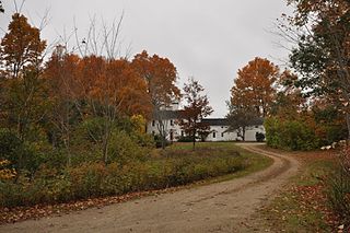
Rivercroft Farm is a historic farm complex on River Street in Fryeburg, Maine. The farm has been in the hands of the Weston family for many generations, and is one of the largest agricultural operations in Fryeburg. The centerpiece of the complex, on the south side of River Street, is an impressive Second Empire house built 1870-73, and believed to be designed by Portland architect Frances Fassett. It is a 2-1/2 story wood frame structure on a stone foundation. Its main block has a mansard roof; ells extend to the rear of the house that have gable roofs. The main facade is three bays wide, with a center entry flanked by paired sash windows, and a four-column porch extending across its width. The roof cornice and dormers have fine woodwork decoration typical of the Second Empire style.
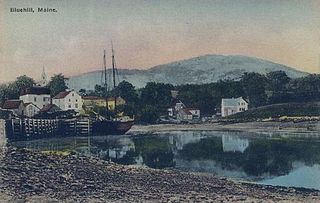
The Blue Hill Historic District encompasses the historic village center of the town of Blue Hill, Maine. The village, established in 1762, is a well-preserved collection of buildings, many of them built before 1840. Most of the older buildings are residential in character; the modest collection of commercial and civic buildings were mostly built between 1880 and 1940. The district was listed on the National Register of Historic Places in 1980.

The Former Town House of Salem, Maine, now the Salem Community Building, is located on Maine State Route 142, a short way west of Mt. Abram Regional High School. Completed in 1858, it is the only civic building built during the existence of the municipality, which was established in 1823 and disincorporated in 1945. The church-like building is architecturally notable for its Italianate styling, and for its social history as the site of community social and government activity. The building was listed on the National Register of Historic Places in 2005.

The Larsson–Noak Historic District encompasses a collection of buildings constructed by Swedish immigrants to northern Maine between about 1888 and 1930. The district is focused on a cluster of four buildings on Station Road, northeast of the center of New Sweden, Maine. Notable among these is the c. 1888 Larsson-Ostlund House, which is the only known two-story log house built using Swedish construction techniques in the state. Across the street is the c. 1900 Noak Blacksmith Shop, a virtually unaltered building housing original equipment. The district was listed on the National Register of Historic Places in 1989.

The Limington Historic District encompasses the historic village center of the rural community of Limington, Maine. Centered at the junction of Maine State Routes 11 and 117, the district includes 24 buildings erected between the late 18th and mid-19th centuries. The district was listed on the National Register of Historic Places in 1999.

The East Main Street Historic District of Searsport, Maine encompasses an architecturally distinctive collection of five residential properties on United States Route 1 east of the town center. All five houses are at least somewhat Italianate in style, and were built by ship's captains between about 1860 and 1875. The district was listed on the National Register of Historic Places in 1991; three of the properties are also individually listed.
The James Smith Homestead is a historic house on 5 Russell Farm Road in Kennebunk, Maine. Built in 1753, it is one of the few surviving mid-18th century inland farmhouses in the town. It was listed on the National Register of Historic Places in 1982, and is included in the Lower Alewive Historic District.
The Hunnewell House is one of the oldest surviving structures in the United States state of Maine. Located on Old County Road near Black Point Road in Scarborough, Maine, this modest single-story building was probably built in 1702-03 by Richard Hunnewell, who had first settled Scarborough in 1684. Although, the exact year of construction is in doubt, with some accounts listing it as 1673. The house was listed on the National Register of Historic Places in 1976. It is now owned and maintained by the town.

The Hamblen Development Historic District encompasses a modest collection of Greek Revival residential properties at 188–208 Danforth Street in Portland, Maine. They were built in 1835–36 as a speculative venture by members of the Hamblen family, and are a rare surviving cluster of development in the city from this period. The district was listed on the National Register of Historic Places in 1992.
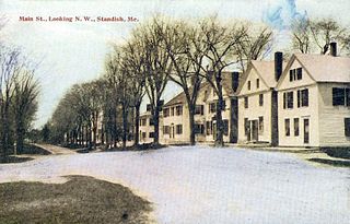
The Standish Corner Historic District encompasses a collection of five early farmhouses in the village of Standish Corner in southeastern Standish, Maine. All five houses were built in the late 18th or early 19th century, and the assemblage are all that survive of the town's original early center. The district was listed on the National Register of Historic Places in 1993.
The South Street Historic District encompasses an early residential area of Gorham, Maine. Located just south of Gorham's small commercial center, South Street is lined with an architecturally cohesive collection of about 20 late-18th and early-19th century houses, primarily interrupted only by the presence of the modest Colonial Revival Baxter Memorial Library. The district was listed on the National Register of Historic Places in 1988.
The State Reform School Historic District encompasses the surviving early buildings of the former Maine State Reform School for Boys off Westbrook Street in South Portland, Maine. The complex was developed between 1850 and 1921, and was redeveloped into apartments and other uses in the 2000s. The area, part of South Portland's Brick Hill neighborhood, was listed on the National Register of Historic Places in 1985.

The Wiscasset Historic District is a 101-acre (41 ha) historic district that encompasses substantially all of the central village of Wiscasset, Maine. The district includes at least 22 contributing buildings and two other contributing sites, one being a cemetery whose oldest stone is from 1739. Located on the west bank of the Sheepscot River and settled in the 18th century, Wiscasset was a prominent harbor in Mid Coast Maine, and a major shipbuilding and merchant port, until the War of 1812 ended its prosperity. The village center includes fine examples of Federal period architecture, most built between about 1780 and 1820, including one National Historic Landmark, the Nickels-Sortwell House. The district was listed on the National Register of Historic Places in 1973.