Palmyra Township | |
|---|---|
 Rose Hill Farmstead, a historic site in the township | |
 | |
| Coordinates: 38°40′49″N87°24′34″W / 38.68028°N 87.40944°W | |
| Country | United States |
| State | Indiana |
| County | Knox |
| Government | |
| • Type | Indiana township |
| Area | |
• Total | 37.48 sq mi (97.1 km2) |
| • Land | 37.47 sq mi (97.0 km2) |
| • Water | 0.01 sq mi (0.026 km2) |
| Elevation | 505 ft (154 m) |
| Population (2020) | |
• Total | 1,512 |
| • Density | 40.35/sq mi (15.58/km2) |
| FIPS code | 18-57744 [2] |
| GNIS feature ID | 453704 |
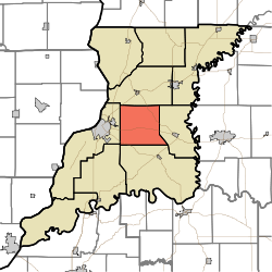
Palmyra Township is one of ten townships in Knox County, Indiana. As of the 2020 census, its population was 1,512 (up from 1,466 at 2010 [3] ) and it contained 632 housing units. [4]
Contents
| Census | Pop. | Note | %± |
|---|---|---|---|
| 1890 | 1,241 | — | |
| 1900 | 1,364 | 9.9% | |
| 1910 | 1,201 | −12.0% | |
| 1920 | 1,143 | −4.8% | |
| 1930 | 1,102 | −3.6% | |
| 1940 | 1,083 | −1.7% | |
| 1950 | 1,136 | 4.9% | |
| 1960 | 1,204 | 6.0% | |
| 1970 | 1,188 | −1.3% | |
| 1980 | 1,578 | 32.8% | |
| 1990 | 1,401 | −11.2% | |
| 2000 | 1,593 | 13.7% | |
| 2010 | 1,466 | −8.0% | |
| 2020 | 1,512 | 3.1% | |
| Source: US Decennial Census [5] | |||
