Widner Township | |
|---|---|
 | |
| Coordinates: 38°51′52″N87°20′34″W / 38.86444°N 87.34278°W | |
| Country | United States |
| State | Indiana |
| County | Knox |
| Established | 1804 |
| Founded by | John Widner |
| Government | |
| • Type | Indiana township |
| Area | |
• Total | 41.24 sq mi (106.8 km2) |
| • Land | 41.2 sq mi (107 km2) |
| • Water | 0.04 sq mi (0.10 km2) |
| Elevation | 443 ft (135 m) |
| Population (2020) | |
• Total | 1,094 |
| • Density | 26.6/sq mi (10.3/km2) |
| Time zone | UTC-5 (EST) |
| • Summer (DST) | UTC-4 (EDT) |
| FIPS code | 18-84158 [2] |
| GNIS feature ID | 454058 |
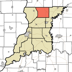
Widner Township is one of ten townships in Knox County, Indiana. As of the 2010 census, its population was 1,094 (down from 1,132 at 2010 [3] ) and it contained 506 housing units. [4] It contains the census-designated place of Freelandville.
Contents
| Census | Pop. | Note | %± |
|---|---|---|---|
| 1890 | 1,820 | — | |
| 1900 | 1,719 | −5.5% | |
| 1910 | 1,767 | 2.8% | |
| 1920 | 1,745 | −1.2% | |
| 1930 | 1,583 | −9.3% | |
| 1940 | 1,611 | 1.8% | |
| 1950 | 1,540 | −4.4% | |
| 1960 | 1,338 | −13.1% | |
| 1970 | 1,278 | −4.5% | |
| 1980 | 1,287 | 0.7% | |
| 1990 | 1,197 | −7.0% | |
| 2000 | 1,165 | −2.7% | |
| 2010 | 1,132 | −2.8% | |
| 2020 | 1,094 | −3.4% | |
| Source: US Decennial Census [5] | |||
