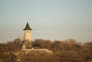
Prospect Park is a historic neighborhood within the University community of the U.S. city of Minneapolis, Minnesota. The area is bounded by the Mississippi River to the south, the City of Saint Paul, Minnesota to the east, the Burlington Northern railroad yard to the north, and the Stadium Village commercial district of the University of Minnesota to the west. The neighborhood is composed of several districts which include the East River Road area. The 1913 Prospect Park Water Tower is a landmark and neighborhood icon.

The Frank B. Kellogg House is a historic house at 633 Fairmount Avenue in Saint Paul, Minnesota, United States. It is listed as a National Historic Landmark for its association with Nobel Peace Prize-winner Frank B. Kellogg, co-author of the Kellogg–Briand Pact. Kellogg Boulevard in downtown Saint Paul is also named for him. The house was designated a National Historic Landmark in 1976. It is also a contributing property to the Historic Hill District.

The F. Scott Fitzgerald House, also known as Summit Terrace, in Saint Paul, Minnesota, United States, is part of a rowhouse designed by William H. Willcox and Clarence H. Johnston, Sr. The house, at 599 Summit Avenue, is listed as a National Historic Landmark for its association with author F. Scott Fitzgerald. The design of the rowhouse was called the "New York Style", where each unit was given a distinctive character similar to rowhouses in eastern cities. Architecture critic Larry Millett describes it as "A brownstone row house that leaves no Victorian style unaccounted for, although the general flavor is Romanesque Revival." The Fitzgerald house is a brownstone two bays wide, with a polygonal two-story window bay on the right, and the entrance, recessed under a round arch that is flush with the bay front, on the left. At the mansarded roof level there is a gable with two round-arch windows and decorative finials.

Summit Avenue is a street in Saint Paul, Minnesota, United States, known for being the longest avenue of Victorian homes in the country, having a number of historic houses, churches, synagogues, and schools. The street starts just west of downtown Saint Paul and continues four and a half miles west to the Mississippi River where Saint Paul meets Minneapolis. Other cities have similar streets, such as Prairie Avenue in Chicago, Euclid Avenue in Cleveland, and Fifth Avenue in New York City. Summit Avenue is notable for having preserved its historic character and mix of buildings, as compared to these other examples. Historian Ernest R. Sandeen described Summit Avenue as "the best preserved example of the Victorian monumental residential boulevard."

The Church of the Assumption Catholic Church was dedicated in 1874 and is the oldest existing church in Saint Paul in the state of Minnesota (U.S.). It is located at 51 West Seventh Street, in downtown Saint Paul. The building is listed on the National Register of Historic Places.
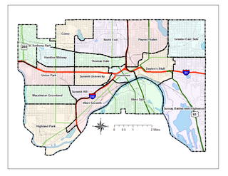
Saint Paul, Minnesota is noted for its neighborhoods. The city has been called "fifteen small towns with one mayor", owing to the neighborhood-based life of much of the city. Saint Paul is partially governed by not 15 but 17 City Districts.
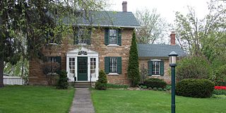
The Frederick Spangenberg House is a historic house in Saint Paul, Minnesota, United States. It was built from 1864 to 1867 as the residence of a farm in what was then rural land outside the urban center. The house was listed on the National Register of Historic Places in 1976 for having local significance in the theme of architecture. Now enveloped by a 20th-century residential neighborhood, it was nominated for being one of the oldest limestone farmhouses preserved in Saint Paul.

This is a list of the National Register of Historic Places listings in Dakota County, Minnesota. It is intended to be a complete list of the properties and districts on the National Register of Historic Places in Dakota County, Minnesota, United States. Dakota County is located in the southeastern part of the U.S. state of Minnesota, bounded on the northeast side by the Upper Mississippi River and on the northwest by the Minnesota River. The locations of National Register properties and districts for which the latitude and longitude coordinates are included below, may be seen in an online map.

The Church of Saint Mary's is a 1909 Beaux-Arts Catholic church, located at 8433 239th Street East, New Trier in the U.S. state of Minnesota. The bright red building sits high on a hill overlooking the town, which was settled by German immigrants from Trier. The immigrants began arriving in 1854, and in 1857, they built a log church. In 1864, they built a larger stone church on a hill above the town.

This list is of the properties and historic districts that are designated on the National Register of Historic Places or that were formerly so designated, in Hennepin County, Minnesota; there are 169 entries as of November 2018. A significant number of these properties are a result of the establishment of Fort Snelling, the development of water power at Saint Anthony Falls, and the thriving city of Minneapolis that developed around the falls. Many historic sites outside the Minneapolis city limits are associated with pioneers who established missions, farms, and schools in areas that are now suburbs in that metropolitan area.

This is a complete list of National Register of Historic Places listings in Ramsey County, Minnesota. It is intended to be a complete list of the properties and districts on the National Register of Historic Places in Ramsey County, Minnesota, United States. The locations of National Register properties and districts for which the latitude and longitude coordinates are included below, may be seen in an online map.

The Church of Saint Agnes is an onion-domed church building designed by George Ries, built 1901–1912 for the German-speaking Austro-Hungarian population of immigrants in Saint Paul, Minnesota, United States. It is listed on the National Register of Historic Places.
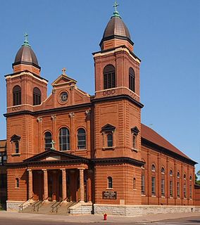
The Church of Saint Casimir is church building built in 1904 in the Beaux Arts style in Saint Paul, Minnesota, United States. It is listed on the National Register of Historic Places. The church was founded to serve the needs of Polish American immigrants.

Saint Paul is the second largest city in the state of Minnesota in the United States, the county seat of Ramsey County, and the state capital of Minnesota. The origin and growth of the city was spurred by the proximity of Fort Snelling, the first major United States military presence in the area, and by its location on the Upper Mississippi River, with the northernmost natural navigable port on the mighty river.

The Norway Lutheran Church or Old Muskego Church stands on the edge of the campus of Luther Seminary in Saint Paul, Minnesota.
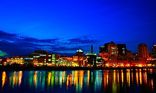
Downtown Saint Paul is an official neighborhood in Saint Paul, Minnesota, United States. Its boundaries are the Mississippi River to the south, University Avenue to the north, US 52 to the east, and Kellogg Avenue to the west. It is bounded by the Dayton's Bluff, Summit-University, West Seventh, Frogtown, West Side, and Payne-Phalen neighborhoods. The West Side neighborhood is on the other side of the river, and can be accessed via the Robert Street Bridge or the Wabasha Street Bridge. Interstate 35E and Interstate 94 run through the north side of the neighborhood, providing a separation between the Minnesota State Capitol and other state government buildings with the rest of downtown.

The Church of St. Wenceslaus is a Catholic church in New Prague, Minnesota, United States, constructed in 1907. The church is flanked by a 1908 rectory and a 1914 parochial school, and the three-building complex is listed on the National Register of Historic Places for its association with the Czech American settlement of south-central Minnesota.

Frogtown is a neighborhood in Saint Paul in the U.S. state of Minnesota. Built around University Avenue, the Thomas-Dale neighborhood is colloquially known as Frogtown. Historically, Frogtown was a subsection of the current Thomas-Dale neighborhood. It is bordered by University Avenue on the south, the Burlington Northern Railroad tracks to the north, Lexington Parkway on the west and Rice Street on the east.

Grace University Lutheran Church is a church in Minneapolis, Minnesota, United States, adjacent to the University of Minnesota East Bank campus. The church was built in 1915-1917 by a Swedish Lutheran congregation to serve neighborhood families and university students. It was designed by Chapman and Magney and built in the Gothic Revival style.

