Penobscot Expedition Site

Last updated
Penobscot Expedition Site

PenobscotExpeditionSalvage.jpg

A cannon is salvaged from the river in 2000
Nearest city Bangor and Brewer, Maine
Area 30 acres (12 ha)
Built 1779 (1779)
NRHP reference # 73000140 [1]
Added to NRHP April 23, 1973

The Penobscot Expedition Site is a submerged historic archaeological area in the waters of the Penobscot River between Bangor and Brewer, Maine. The area is the site of the abandonment and loss of many vessels in the disastrous 1779 Penobscot Expedition, an American Revolutionary War expedition in which the rebellious Americans lost an entire fleet of ships. The site was listed on the National Register of Historic Places in 1973; it has been of interest to salvagers and later archaeologists since the early 19th century. [1]

Penobscot River river in the US state of Maine

The Penobscot River is a 109-mile-long (175 km) river in the U.S. state of Maine. Including the river's West Branch and South Branch increases the Penobscot's length to 264 miles (425 km), making it the second-longest river system in Maine and the longest entirely in the state. Its drainage basin contains 8,610 square miles (22,300 km2).

Bangor, Maine City in Maine, United States

Bangor is a city in the U.S. state of Maine, and the county seat of Penobscot County. The city proper has a population of 33,039, making it the state's 3rd largest settlement behind Portland (66,882) and Lewiston (36,221).

Brewer, Maine City in Maine, United States

Brewer is a city in Penobscot County, Maine, United States. It is part of the Bangor, Maine Metropolitan Statistical Area. The city is named after its first settler, Colonel John Brewer. The population was 9,482 at the 2010 census.

Contents

Description and history

The Penobscot River flows into Penobscot Bay, a long bay that nearly bisects the state of Maine. At its head of navigation stand the cities of Bangor (on its western bank) and Brewer (on its eastern bank). The 1779 Penobscot Expedition was a military response by the state of Massachusetts (of which Maine was then part) to the seizure of Castine by British forces in June 1779. Beset by poor leadership, the amphibious expedition was scattered by the arrival of a British fleet on the bay. All of the expedition's ships were captured, scuttled, burned, or abandoned. Nine armed vessels and as many as 16 transports are documented to have made it as far upriver as Bangor. [2]

Penobscot Bay Bay in Maine, United States

Penobscot Bay is an inlet of the Gulf of Maine and Atlantic Ocean in south central Maine. The bay originates from the mouth of Maine's Penobscot River, downriver from Belfast. Penobscot Bay has many working waterfronts including Rockland, Rockport, and Stonington, and Belfast upriver. Penobscot Bay is between Muscongus Bay and Blue Hill Bay, just west of Acadia National Park.

Head of navigation is the farthest point above the mouth of a river that can be navigated by ships. Determining the head of navigation can be subjective on many streams, as this point may vary greatly with the size of the ship being contemplated for navigation and the seasonal water level. On others, it is quite objective, being caused by a waterfall, a low bridge which is not a drawbridge, or a dam without navigation locks. Several rivers in a region may have their heads of navigation along a line called the fall line.

Massachusetts State of the United States of America

Massachusetts, officially the Commonwealth of Massachusetts, is the most populous state in the New England region of the northeastern United States. It borders on the Atlantic Ocean to the east, the states of Connecticut and Rhode Island to the south, New Hampshire and Vermont to the north, and New York to the west. The state is named after the Massachusett tribe, which once inhabited the east side of the area, and is one of the original thirteen states. The capital of Massachusetts is Boston, which is also the most populous city in New England. Over 80% of Massachusetts's population lives in the Greater Boston metropolitan area, a region influential upon American history, academia, and industry. Originally dependent on agriculture, fishing and trade, Massachusetts was transformed into a manufacturing center during the Industrial Revolution. During the 20th century, Massachusetts's economy shifted from manufacturing to services. Modern Massachusetts is a global leader in biotechnology, engineering, higher education, finance, and maritime trade.

Some materials were salvaged by the Royal Navy from the abandoned and sunken ships not long after the expedition. Readily-accessible wrecks were salvaged by local residents, and the state also authorized at least one formal salvage operation, whose results are not known. In 1809 Ebenezer Clifford recovered 30 cannons and several tons of cannonballs from the river. [3] Later finds in the Penobscot River included cannons found on the river bottom in the Bangor-Brewer area in 1876 and in 1954-55. The obvious importance of the area, with a well-documented history, led to the area's listing on the National Register of Historic Places in 1973, primarily for the potential archaeological significance of materials located there, including military equipment, cargo, and other artifacts. [2]

National Register of Historic Places federal list of historic sites in the United States

The National Register of Historic Places (NRHP) is the United States federal government's official list of districts, sites, buildings, structures, and objects deemed worthy of preservation for their historical significance. A property listed in the National Register, or located within a National Register Historic District, may qualify for tax incentives derived from the total value of expenses incurred preserving the property.

Between 1994 and 1997 surveys conducted by the University of Maine located several wrecks in the Penobscot, tentatively identified as the USS Warren and the transport Samuel. In 1998 Brent Phinney, the owner of a riverfront industrial business in Brewer, reported the presence of Revolutionary War-era finds near his property in Brewer, and opposite downtown Bangor. These prompted archaeological teams from the United States Navy (which retains an interest in military shipwrecks) to conduct preliminary surveys in 1999, and more detailed fieldwork and excavation in 2000 and 2001. These surveys determined that the Phinney Site on the Brewer side was of a shipwreck, and that the Shoreline Site on the Bangor side consisted of dispersed artifacts, including cannon and other military hardware. The ship was determined to be a two-masted brig or schooner, and has tentatively been identified as the privateer Diligent. [3]

University of Maine Public university in Orono, Maine, USA

The University of Maine is a public research university in Orono, Maine, United States. The university was established in 1865 as a land grant college and is the flagship university of the University of Maine System. The University of Maine is one of only a few land, sea and space grant institutions in the nation.

USS Warren was one of the 13 frigates authorized by the Continental Congress on 13 December 1775. With half her main armament being 18-pounders, Warren was more heavily armed than a typical 32-gun frigate of the period. She was named for Joseph Warren on 6 June 1776. Warren was burned to prevent capture in the ill-fated Penobscot Expedition in 1779.

United States Navy Naval warfare branch of the United States Armed Forces

The United States Navy (USN) is the naval warfare service branch of the United States Armed Forces and one of the seven uniformed services of the United States. It is the largest and most capable navy in the world and it has been estimated that in terms of tonnage of its active battle fleet alone, it is larger than the next 13 navies combined, which includes 11 U.S. allies or partner nations. with the highest combined battle fleet tonnage and the world's largest aircraft carrier fleet, with eleven in service, and two new carriers under construction. With 319,421 personnel on active duty and 99,616 in the Ready Reserve, the Navy is the third largest of the service branches. It has 282 deployable combat vessels and more than 3,700 operational aircraft as of March 2018, making it the second-largest air force in the world, after the United States Air Force.

See also

National Register of Historic Places listings in Penobscot County, Maine Wikimedia list article

This is a list of the National Register of Historic Places listings in Penobscot County, Maine.

Related Research Articles

Maritime archaeology archaeological study of human interaction with the sea

Maritime archaeology is a discipline within archaeology as a whole that specifically studies human interaction with the sea, lakes and rivers through the study of associated physical remains, be they vessels, shore-side facilities, port-related structures, cargoes, human remains and submerged landscapes. A specialty within maritime archaeology is nautical archaeology, which studies ship construction and use.

Shipwreck The remains of a ship that has wrecked

A shipwreck is the remains of a ship that has wrecked, which are found either beached on land or sunken to the bottom of a body of water. Shipwrecking may be deliberate or accidental. In January 1999, Angela Croome estimated that there have been about three million shipwrecks worldwide.

Penobscot Expedition

The Penobscot Expedition was a 44-ship American naval task force mounted during the Revolutionary War by the Provincial Congress of the Province of Massachusetts Bay. The flotilla of 19 warships and 25 smaller support vessels sailed from Boston on July 19, 1779 for the upper Penobscot Bay in the District of Maine carrying a ground expeditionary force of more than 1,000 colonial Marines and militiamen. Also included was a 100-man artillery detachment under the command of Lt. Colonel Paul Revere. The Expedition's goal was to reclaim control of what is now mid-coast Maine from the British who had seized it a month earlier and renamed it New Ireland. It was the largest American naval expedition of the war. The fighting took place both on land and at sea in and around the mouth of the Penobscot and Bagaduce Rivers at what is today Castine, Maine over a period of three weeks in July and August of 1779. One of its greatest victories of the war for the British, the Expedition was also the United States' worst naval defeat until Pearl Harbor 162 years later in 1941.

Fort Knox (Maine) Fort in Maine, United States

Fort Knox, now Fort Knox State Park or Fort Knox State Historic Site, is located on the western bank of the Penobscot River in the town of Prospect, Maine, about 5 miles (8.0 km) from the mouth of the river. Built between 1844 and 1869, it was the first fort in Maine built entirely of granite; most previous forts used wood, earth, and stone. It is named after Major General Henry Knox, the first U.S. Secretary of War and Commander of Artillery during the American Revolutionary War, who at the end of his life lived not far away in Thomaston. As a virtually intact example of a mid-19th century granite coastal fortification, it was added to the National Register of Historic Places in 1969 and declared a National Historic Landmark on December 30, 1970. Fort Knox also serves as the entry site for the observation tower of the Penobscot Narrows Bridge that opened to the public in 2007.

CSS <i>Georgia</i> (ironclad)

CSS Georgia, also known as State of Georgia and Ladies' Ram, was an ironclad warship built in Savannah, Georgia in 1862 during the American Civil War. The Ladies' Gunboat Association raised $115,000 for her construction to defend the port city of Savannah.

<i>Queen Annes Revenge</i> Pirate Blackbeards ship

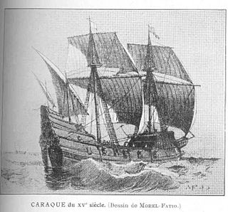
Queen Anne's Revenge was an early-18th-century ship, most famously used as a flagship by the pirate Blackbeard. Although the date and place of the ship's construction are uncertain, it was believed she was built for merchant service in Bristol in 1710 and named Concord, later captured by French privateers and renamed La Concorde. This origin hypothesis was found to be incorrect and has been dismissed by the project crew. After several years' service with the French, she was captured by Blackbeard in 1717. Blackbeard used the ship for less than a year, but captured numerous prizes using her as his flagship.

HMS <i>Culloden</i> (1776)

HMS Culloden was a 74-gun third-rate ship of the line of the Royal Navy, built at Deptford Dockyard, England, and launched on 18 May 1776. She was the fourth warship to be named after the Battle of Culloden, which took place in Scotland in 1746 and saw the defeat of the Jacobite rising.

Mensun Bound British marine archaeologist

Mensun Bound is a British maritime archaeologist. Born in Port Stanley, Falkland Islands. A fifth generation Islander whose great great grandfather arrived with the first colonists in the 1840s. He is best known for directing the excavation of the Etruscan 6th century BC shipwreck off Giglio Island, Italy, the oldest known shipwreck of the Archaic era, and the Hoi An Cargo which revolutionized understanding of Vietnam’s art-historical Golden Age.

Barry Clifford Underwater archeologist, discovered pirate ship Whydah

Barry Clifford is an underwater archaeological explorer best known for discovering the remains of Samuel Bellamy's wrecked pirate ship Whydah [pronounced wih-duh], the only fully verified and authenticated pirate shipwreck of the Golden Age of Piracy ever discovered in the world – as such, artifacts from the wreck provide historians with unique insights into the material, political and social culture of early 18th-century piracy.

Underwater Archaeology Branch, Naval History & Heritage Command unit of the United States Department of the Navy

The Underwater Archaeology Branch (UAB) of the Naval History & Heritage Command (NHHC) is a unit of the United States Department of the Navy. It was formally founded in 1996 as a consequence of the emerging need to manage, study, conserve, and curate the U.S. Navy's submerged cultural resources.

<i>Defence</i> (1779 brigantine) American Revolutionary War privateer

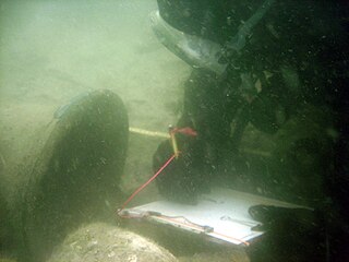
Defence was an American Revolutionary War privateer that was part of the 1779 Penobscot Expedition, during the American Revolutionary War. A brigantine, she was built that year in Beverly, Massachusetts, and was scuttled near Stockton Springs, Maine in the later stages of the expedition. The wreck site was excavated in the 1970s, and was listed on the National Register of Historic Places in 1975.

The Molasses Reef Shipwreck is the site of a ship which wrecked in the Turks and Caicos Islands early in the 16th century. It is the oldest wreck of a European ship in the Americas to have been scientifically excavated.

<i>Alvin Clark</i> (schooner)

Alvin Clark was a schooner which was constructed in 1847 and sank in Green Bay in 1864. It was salvaged in 1969 and moored in Menominee, Michigan at the Mystery Ship Seaport, located in the Menominee River at the foot of Sixth Avenue. The ship was designated a Michigan State Historic Site in 1972 and listed on the National Register of Historic Places in 1974. Although the schooner was in pristine condition when raised, no plans were in place for its conservation, and the ship rapidly deteriorated. The remains of Alvin Clark were destroyed in 1994.

New Ireland (Maine) defunct colony of the British Empire

New Ireland was a Crown colony of the United Kingdom established in modern-day Maine after British forces captured the area during the American Revolution and again during the War of 1812. The colony lasted four years during the Revolution, and eight months during the War of 1812. At the end of each war the United Kingdom ceded the land back to the United States under the Treaty of Paris and Treaty of Ghent, respectively.

<i>San Esteban</i> (1554 shipwreck)

San Esteban was a Spanish cargo ship that was wrecked in a storm in the Gulf of Mexico on what is now the Padre Island National Seashore in southern Texas on 29 April 1554.

Castine Historic District

The Castine Historic District encompasses the entire southern tip of the peninsula on which the town of Castine, Maine is located. Covering about 1,800 acres (730 ha), this area was a center of colonial conflicts dating to the early 17th century, and was the site of military action during the American Revolutionary War and the War of 1812. Bypassed by the railroads, it has retained a village feel reminiscent of the early 19th century. It was listed on the National Register of Historic Places in 1973.

Gut Island is a small 2-acre (0.81 ha) island in the Penobscot River, near Old Town and Milford in central Maine. The island, owned by the Penobscot Indian Nation, is archaeologically important, and has been designated Site 74.91 by the Maine Archaeological Survey. It was listed on the National Register of Historic Places in 1994 for its archaeological significance, which includes well-stratified evidence of human habitation dating back thousands of years.

Archeological Site No. 74-2 is a prehistoric site in Indian Island, Maine. Located on a terrace above the Penobscot River, the site dates to the Middle Archaic Period, a rarity in Maine, made even more unusual by the absence of later period artifacts. The site was listed on the National Register of Historic Places in 1984, for its potential to increase what is known about Native settlement patterns in the area.

References

  1. 1 2 National Park Service (2010-07-09). "National Register Information System". National Register of Historic Places . National Park Service.
  2. 1 2 Kelly, Richard (1972). NRHP nomination for Penobscot Expedition Site; redacted version available by request from the National Park Service
  3. 1 2 "The Penobscot Expedition Archaeological Project: Field Investigations 2000 and 2001" (PDF). United States Navy. Archived from the original (PDF) on 2012-10-17. Retrieved 2015-09-03.