Perrinton, Michigan

Last updated

Perrinton, Michigan
Gratiot County Michigan Incorporated and Unincorporated areas Perrinton Highlighted.svg
Location of Perrinton, Michigan
Coordinates: 43°10′54″N84°40′52″W / 43.18167°N 84.68111°W / 43.18167; -84.68111
Country United States
State Michigan
County Gratiot
Area
[1]
  Total0.64 sq mi (1.66 km2)
  Land0.63 sq mi (1.64 km2)
  Water0.01 sq mi (0.02 km2)
Elevation
732 ft (223 m)
Population
 (2020)
  Total393
  Density621.84/sq mi (239.92/km2)
Time zone UTC-5 (Eastern (EST))
  Summer (DST) UTC-4 (EDT)
ZIP code
48871
Area code 989
FIPS code 26-63660 [2]
GNIS feature ID0634663 [3]

Perrinton is a village in Fulton Township, Gratiot County in the U.S. state of Michigan. The population was 406 at the 2010 census.

Contents

Geography

According to the United States Census Bureau, the village has a total area of 0.64 square miles (1.66 km2), of which 0.63 square miles (1.63 km2) is land and 0.01 square miles (0.03 km2) is water. [4]

Demographics

Historical population
CensusPop.Note
1890 349
1900 330−5.4%
1910 288−12.7%
1920 41945.5%
1930 373−11.0%
1940 3853.2%
1950 383−0.5%
1960 42410.7%
1970 48915.3%
1980 448−8.4%
1990 393−12.3%
2000 43911.7%
2010 406−7.5%
2020 393−3.2%
U.S. Decennial Census [5]

2010 census

As of the census [6] of 2010, there were 406 people, 161 households, and 103 families living in the village. The population density was 644.4 inhabitants per square mile (248.8/km2). There were 175 housing units at an average density of 277.8 per square mile (107.3/km2). The racial makeup of the village was 95.6% White, 0.2% African American, 0.2% Asian, 2.5% from other races, and 1.5% from two or more races. Hispanic or Latino of any race were 3.2% of the population.

There were 161 households, of which 32.9% had children under the age of 18 living with them, 40.4% were married couples living together, 16.1% had a female householder with no husband present, 7.5% had a male householder with no wife present, and 36.0% were non-families. 28.0% of all households were made up of individuals, and 11.2% had someone living alone who was 65 years of age or older. The average household size was 2.52 and the average family size was 3.07.

The median age in the village was 38.4 years. 24.6% of residents were under the age of 18; 9.3% were between the ages of 18 and 24; 24.9% were from 25 to 44; 27.6% were from 45 to 64; and 13.8% were 65 years of age or older. The gender makeup of the village was 49.3% male and 50.7% female.

2000 census

As of the census [2] of 2000, there were 439 people, 166 households, and 114 families living in the village. The population density was 699.4 inhabitants per square mile (270.0/km2). There were 173 housing units at an average density of 275.6 per square mile (106.4/km2). The racial makeup of the village was 97.95% White, 0.46% from other races, and 1.59% from two or more races. Hispanic or Latino of any race were 0.68% of the population.

There were 166 households, out of which 31.3% had children under the age of 18 living with them, 52.4% were married couples living together, 12.0% had a female householder with no husband present, and 31.3% were non-families. 27.7% of all households were made up of individuals, and 15.1% had someone living alone who was 65 years of age or older. The average household size was 2.64 and the average family size was 3.20.

In the village, the population was spread out, with 27.8% under the age of 18, 10.0% from 18 to 24, 28.7% from 25 to 44, 21.6% from 45 to 64, and 11.8% who were 65 years of age or older. The median age was 35 years. For every 100 females, there were 89.2 males. For every 100 females age 18 and over, there were 88.7 males.

The median income for a household in the village was $34,500, and the median income for a family was $38,929. Males had a median income of $35,909 versus $18,125 for females. The per capita income for the village was $16,988. About 12.3% of families and 14.4% of the population were below the poverty line, including 18.7% of those under age 18 and 16.0% of those age 65 or over.

Related Research Articles

<span class="mw-page-title-main">North Buena Vista, Iowa</span> City in Iowa, United States

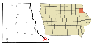
North Buena Vista is a city in Clayton County, Iowa, United States. The population was 109 at the time of the 2020 census, down from 124 in 2000.

<span class="mw-page-title-main">Miramiguoa Park, Missouri</span> Village in Missouri, United States

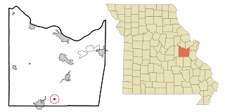
Miramiguoa Park is a village in Franklin County, Missouri, United States. The population was 120 at the 2010 census.

<span class="mw-page-title-main">Cedar Hill Lakes, Missouri</span> Village in Missouri, United States

Cedar Hill Lakes is a village in Jefferson County, Missouri, United States. The population was 203 at the 2020 census.

<span class="mw-page-title-main">Sycamore Hills, Missouri</span> Village in Missouri, United States

Sycamore Hills is a village in St. Louis County, Missouri, United States. The population is 560 at the 2020 census.

<span class="mw-page-title-main">Hanley Hills, Missouri</span> Village in Missouri, United States

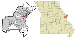
Hanley Hills is a village in St. Louis County, Missouri, United States. The population was 2,101 at the 2010 census.

<span class="mw-page-title-main">Oswegatchie, New York</span> Town in New York, United States

Oswegatchie is a town in St. Lawrence County, New York, United States. The population was 4,397 at the 2010 census. The name reportedly means "Black Water". It is on the northern border of the county and is adjacent to the city of Ogdensburg.

<span class="mw-page-title-main">Wayne Lakes, Ohio</span> Village in Ohio, United States

Wayne Lakes is a village in Darke County, Ohio, United States. The population was 693 at the 2020 census.

<span class="mw-page-title-main">Addyston, Ohio</span> Village in Ohio, United States

Addyston is a village in Miami Township, Hamilton County, Ohio, United States. Located along the Ohio River, it is a western suburb of the neighboring city of Cincinnati. The population was 927 at the 2020 census.

<span class="mw-page-title-main">Cleves, Ohio</span> City in Ohio, United States

Cleves is a village in Miami Township, Hamilton County, Ohio, United States. Located along the Ohio River, it is a western suburb of Cincinnati. The population was 3,414 at the 2020 census.

<span class="mw-page-title-main">Elmwood Place, Ohio</span> Village in Hamilton County, Ohio, United States

Elmwood Place is a village in Hamilton County, Ohio, United States. The population was 2,087 at the 2020 census. Except for a small portion which touches neighboring St. Bernard, Elmwood Place is nearly surrounded by the city of Cincinnati.

<span class="mw-page-title-main">Woodlawn, Ohio</span> Village in Ohio, United States

Woodlawn is a village in Hamilton County, Ohio, United States. The population was 3,916 at the 2020 census.

<span class="mw-page-title-main">Hanover, Ohio</span> Village in Ohio, United States

Hanover is a village in Licking County, Ohio, United States. The population was 1,270 at the 2020 census. The village lies along Ohio State Route 16.

<span class="mw-page-title-main">Hartville, Ohio</span> Village in Ohio, United States

Hartville is a village in northern Stark County, Ohio, United States. The population was 3,329 at the 2020 census. It is part of the Canton–Massillon metropolitan area. Hartville lies halfway between Akron and Canton at the intersection of State Routes 43 and 619.

<span class="mw-page-title-main">Lake Heritage, Pennsylvania</span> Census-designated place in Pennsylvania, United States

Lake Heritage is a census-designated place (CDP) in Adams County, Pennsylvania, United States. Its population was 2,158 at the 2020 census.

<span class="mw-page-title-main">Lake Wynonah, Pennsylvania</span> CDP in Pennsylvania, United States

Lake Wynonah is a census-designated place (CDP) in Schuylkill County, Pennsylvania, United States. The population was 1,961 at the 2000 census, and 2,640 at the 2010 census. Lake Wynonah is a gated community with two lakes, Fawn Lake and Lake Wynonah, and as of July 2008, there are over 1200 homes and 1500 members. It is in South Manheim and Wayne Townships.

<span class="mw-page-title-main">Cloverland, Douglas County, Wisconsin</span> Town in Wisconsin, United States

Cloverland is a town in Douglas County, Wisconsin, United States. The population was 247 at the 2000 census. The unincorporated community of Cloverland is located in the town.

<span class="mw-page-title-main">Avoca, Wisconsin</span> Village in Wisconsin, United States

Avoca is a village in Iowa County, Wisconsin, United States. The population was 637 at the 2010 census. It is part of the Madison Metropolitan Statistical Area. It is named after Avoca in Ireland.

<span class="mw-page-title-main">Verona, Ohio</span> Village in Ohio, United States

Verona is a village in Montgomery and Preble counties in the U.S. state of Ohio. The population was 403 at the 2020 census. It is part of the Dayton Metropolitan Statistical Area.

<span class="mw-page-title-main">Chatham (CDP), Massachusetts</span> Census-designated place in Massachusetts, United States

Chatham is a census-designated place (CDP) in the town of Chatham in Barnstable County, Massachusetts, United States. The population was 1,421 at the 2010 census, out of 6,125 in the entire town of Chatham.

<span class="mw-page-title-main">Sherburne (village), New York</span> Village in New York, United States

Sherburne is a village in Chenango County, New York, United States. The population was 1,367 at the 2010 census. It is in the town of Sherburne, north of Norwich.

References

  1. "2020 U.S. Gazetteer Files". United States Census Bureau. Retrieved May 21, 2022.
  2. 1 2 "U.S. Census website". United States Census Bureau . Retrieved January 31, 2008.
  3. "US Board on Geographic Names". United States Geological Survey. October 25, 2007. Retrieved January 31, 2008.
  4. "US Gazetteer files 2010". United States Census Bureau. Archived from the original on January 25, 2012. Retrieved November 25, 2012.
  5. "Census of Population and Housing". Census.gov. Retrieved June 4, 2015.
  6. "U.S. Census website". United States Census Bureau . Retrieved November 25, 2012.

43°10′58″N84°40′45″W / 43.18278°N 84.67917°W / 43.18278; -84.67917