
Palakkad is one of the 14 districts in the Indian state of Kerala. It was carved out of the southeastern region of the former Malabar District on 1 January 1957. It is located at the central region of Kerala and is the second largest district in the state after Idukki. The city of Palakkad is the district headquarters. Palakkad is bordered on the northwest by the Malappuram district, on the southwest by the Thrissur district, on the northeast by Nilgiris district, and on the east by Coimbatore district of Tamil Nadu. The district is nicknamed "The granary of Kerala". Palakkad is the gateway to Kerala due to the presence of the Palakkad Gap, in the Western Ghats. The 2,383 m high Anginda peak, which is situated in the border of Palakkad district, Nilgiris district, and Malappuram district, in Silent Valley National Park, is the highest point of elevation in Palakkad district. Palakkad city is about 347 kilometres (216 mi) northeast of the state capital, Thiruvananthapuram.

Puthunagaram is a town and gram panchayat in the Palakkad district, state of Kerala, India. It is about 10 km south of Palakkad and 8 Km from Kollengode. Palakkad-Pollachi railway line passes through this town.
Padiyoor is a small town in Kannur district of Kerala state, India. Padiyoor village is part of Padiyoor-Kalliad Grama Panchayat in Iritty taluk.
Alathur is a town, taluk and gram panchayat in Palakkad District, Kerala, India. It is the administrative headquarters of the Alathur Taluk and is situated about 24 km from the district headquarters Palakkad through National Highway 544.Gayathripuzha River ,one of the tributary of Bharathapuzha, flows through Alathur. Alathur is one among the 29 Parliamentary Constituencies in Kerala. A Mini Civil Station is also located here which provides government related services.
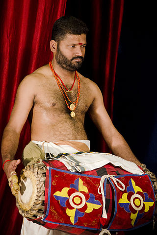
The maddalam or madhalam is a drum made out of the wood of the jackfruit tree. It has two sides for playing, made out of leather, and has different kind of sounds on each side. The maddalam is a heavy instrument which is hung around the waist of the person playing, and the player stands all the while to perform. The maddalam is a vital instrument in traditional Kerala percussion ensembles like Panchavadyam, Keli and Kathakali orchestra.
Panniyannur is a census town in Thalassery taluk of Kannur district in the Indian state of Kerala. It is part of Greater Mahé Region.

Kuttampuzha is a village and gram panchayat in Ernakulam district in the Indian state of Kerala. Situated 71 km east of Kochi, Kuttampuzha panchayat is home to the 17.7% of total area of the Ernakulam District.

Kanichar is a village and Grama Panchayat in Kannur district in the Indian state of Kerala.

Karadka is a village, block panchayat and grama panchayat in Kasaragod district in the state of Kerala, India.
Karindalam is a village in Kasaragod district in the state of Kerala, India.

Keezhattur is a village in Malappuram district in the state of Kerala, India. Poonthanam illam, the birthplace of "bhakthakavi" Poonthanam namboothiri, famous ancient Malayalam poet, is located here. The poonthanam illam is now a popular cultural centre. Keezhattur is a moderately large panchayat.The major place in keezhattur panchayat is kizhattur.'kizhattur pooram' is the major festival in keezhattur. Its administrative offices are located in Akkaparambu, which is about 12 km away from Perinthalmanna, the largest city of Malappuram district.
Ayiloor, also known as Ayilur, Aylur, or Ayalur, is a village in the Chittur Thaluk of Palakkad district, state of Kerala, India. Ayiloor is located about 30 kilometers away from Palakkad town and 48 kilometers from Thrissur town.
Nellaya is a village in Palakkad district in the state of Kerala, India. The village has its own gram panchayat.
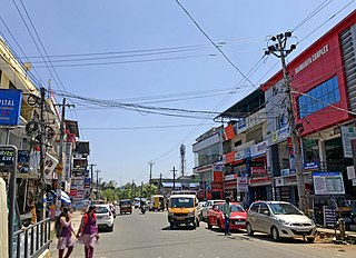
Pirayiri is a residential and commercial area in Palakkad city.It is located about 8 km (5.0 mi) from the city centre.It belongs to Pirayiri gram panchayat in the Palakkad district, state of Kerala, India.
Polpully is a village and gram panchayat in Palakkad district in the state of Kerala, India. The village is located 10 km from Palakkad city, and 5 km from Chittur.

Perinthalmanna is a major town and municipality in Malappuram district, Kerala, India. It serves as the administrative centre for the Perinthalmanna taluk, as well as a revenue division, a community development block, and a police sub-division bearing the same name. It was formerly the headquarters of Valluvanad Taluk, which was one of the two Taluks in the Malappuram Revenue Division of the erstwhile Malabar District during the British Raj. The town is located 23 kilometres (14 mi) southwest to the city of Malappuram at the centre of the Kozhikode–Malappuram–Perinthalmanna–Palakkad National Highway 966.

Agali is a small town in Palakkad district in the state of Kerala, India. It forms a part of the Agali gram panchayat.

Karimba is a gram panchayat in the Palakkad district, state of Kerala, India, near the National Highway 213. The largest town in Karimba panchayath is Kalladikode. It borders with Thachampara, Kongad, Katampazhipuram and Mundur. Recently, it was awarded the Nirmal Gram Title (sanitation). It is the local government organisation that serves the villages of Karimba-I and Karimba-II.
Karimpuzha is a gram panchayat in the Palakkad district, in the state of Kerala, India. It is a local government organisation that serves the villages of Karimpuzha-I and Karimpuzha-II.
Kolachery is a census town and Grama Panchayat in Kannur District of Kerala state, India. Kolachery is located 15 kilometres (9.3 mi) north east of Kannur city.

