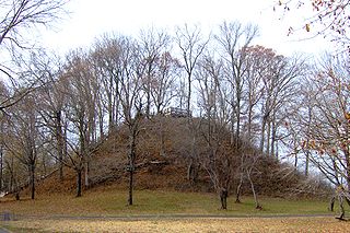
The Pinson Mounds comprise a prehistoric Native American complex located in Madison County, Tennessee, in the region that is known as the Eastern Woodlands. The complex, which includes 17 mounds, an earthen geometric enclosure, and numerous habitation areas, was most likely built during the Middle Woodland period. The complex is the largest group of Middle Woodland mounds in the United States. Sauls' Mound, at 72 feet (22 m), is the second-highest surviving mound in the United States.

Angel Mounds State Historic Site, an expression of the Mississippian culture, is an archaeological site managed by the Indiana State Museum and Historic Sites that includes more than 600 acres of land about 8 miles (13 km) southeast of present-day Evansville, in Vanderburgh and Warrick counties in Indiana. The large residential and agricultural community was constructed and inhabited from AD 1100 to AD 1450, and served as the political, cultural, and economic center of the Angel chiefdom. It extended within 120 miles (190 km) of the Ohio River valley to the Green River in present-day Kentucky. The town had as many as 1,000 inhabitants at its peak, and included a complex of thirteen earthen mounds, hundreds of home sites, a palisade (stockade), and other structures.

Mounds State Park is a state park near Anderson, Madison County, Indiana featuring Native American heritage, and ten ceremonial mounds built by the prehistoric Adena culture indigenous peoples of eastern North America, and also used centuries later by Hopewell culture inhabitants. It is separate from the similarly named Mounds State Recreation Area.

The Grave Creek Mound in the Ohio River Valley in West Virginia is one of the largest conical-type burial mounds in the United States, now standing 62 feet (19 m) high and 240 feet (73 m) in diameter. The builders of the site, members of the Adena culture, moved more than 60,000 tons of dirt to create it about 250–150 BC.

The Kolomoki Mounds is one of the largest and earliest Woodland period earthwork mound complexes in the Southeastern United States and is the largest in Georgia. Constructed from 350CE to 600CE, the mound complex is located in southwest Georgia, in present-day Early County near the Chattahoochee River.
The Archaeological Conservancy is a 501(c)3 non-profit organization that acquires and preserves archaeological sites in the United States. Whereas nearly every other nation protects all archaeological sites within its borders as part of its national patrimony, in the United States archaeological resources on private land are the private property of the landowner. As a result, archaeological sites in the United States are subject to destruction by urban development and sprawl, mechanized agricultural and land-leveling, and commercial looting to fuel the antiquities trade. By the 1970s the extent of archaeological site loss was increasing recognized as a crisis for the scientific study of the nation's past.

The Great Mound is a massive Native American mound in the southwestern part of the U.S. state of Ohio. Located in Section 19 of Madison Township in Butler County, it has a height of 88 feet (27 m) and a circumference of 511 feet (156 m). Its total volume is nearly 825,000 cubic feet (23,400 m3), making it the largest mound in Butler County and one of the largest in southwestern Ohio. Because of the mound's height and its placement on a ridgeline, an individual at the summit can see for a great distance. In the late nineteenth century, it was theorized that mounds such as the Great Mound were built as observation or watch points, and that the builders maintained the ability to light fires atop the mounds as a method of communicating across wide distances. The potential of these mounds for long-distance communication was demonstrated in 1990 by three groups of volunteers. After climbing the Great Mound, the first group established visual contact with the Hill-Kinder Mound in Franklin, from which point the observers of the second group contacted the third group atop the Miamisburg Mound near Dayton.

The Arledge Mounds are a pair of Native American mounds in the south central part of the U.S. state of Ohio. Located near Circleville in Pickaway County, the two mounds lie in the middle of a farm field, far from any roads. These two mounds are disparate in size: while the smaller mound's height is 5 feet (1.5 m), the other's is 20 feet (6.1 m), and their diameters are approximately 65 feet (20 m) and 120 feet (37 m) respectively.

The Nodena Site is an archeological site east of Wilson, Arkansas and northeast of Reverie, Tennessee in Mississippi County, Arkansas, United States. Around 1400–1650 CE an aboriginal palisaded village existed in the Nodena area on a meander bend of the Mississippi River. The Nodena site was discovered and first documented by Dr. James K. Hampson, archaeologist and owner of the plantation on which the Nodena site is located. Artifacts from this site are on display in the Hampson Museum State Park in Wilson, Arkansas. The Nodena Site is the type site for the Nodena Phase, believed by many archaeologists to be the province of Pacaha visited by Spanish explorer Hernando de Soto in 1542.
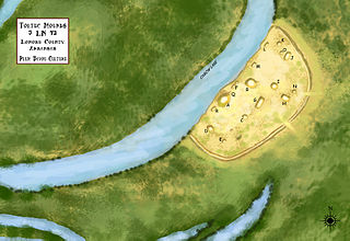
Toltec Mounds Archeological State Park, also known as Knapp Mounds, Toltec Mounds Site or Toltec Mounds, is an archaeological site from the Late Woodland period in Arkansas that protects an 18-mound complex with the tallest surviving prehistoric mounds in Arkansas. The site is on the banks of Mound Lake, an oxbow lake of the Arkansas River. It was occupied by its original inhabitants from 600 to 1050 CE. The site is designated as a National Historic Landmark.
Jaketown Site is an archaeological site with two prehistoric earthwork mounds in Humphreys County, Mississippi, United States. While the mounds have not been excavated, distinctive pottery sherds found in the area lead scholars to date the mounds' construction and use to the Mississippian culture period, roughly 1100 CE to 1500 CE.

This is a list of the National Register of Historic Places listings in Boyd County, Kentucky.

This is a list of the National Register of Historic Places listings in Logan County, Kentucky.

Deprato Mounds, also known as the Ferriday Mounds, is a multi-mound archaeological site located in Concordia Parish, Louisiana. The site shows occupation from the Troyville period to the Middle Coles Creek period. The largest mound at the site has been dated by radiocarbon analysis and decorated pottery to about 600 CE.
Grand Mound is a prehistoric burial site in Koochiching County, Minnesota, United States. It is the largest surviving prehistoric structure in the upper Midwest, dating back to 200 BCE. The site was listed as a National Historic Landmark on June 23, 2011.

The Backusburg Mounds (15-CW-64) are an archaeological site in the Jackson Purchase region of the U.S. state of Kentucky. Located near the tiny community of Backusburg in northwestern Calloway County, the mounds are one of the region's premier archaeological sites. Since at least the early years of the twentieth century, the mounds have been well known locally, due partially to their large size; the largest mound measures 150 by 75 feet at the base. Located on a ridgeline above a fork of the Clarks River, the mound bears a peculiar shape; its size and shape have caused observers to suggest that it might actually be the remnants of a series of smaller mounds placed next to each other. As late as the 1930s, this largest mound had never been plowed; it lay in dense woodland, and among the trees growing upon it were some of considerable size. Nevertheless, the mound has not been preserved entirely without damage; various parts of the mound have been dug into at various times and have yielded numerous artifacts. Such findings are not unprecedented in the area; a field close to Backusburg has long produced skeletons, projectile points, and pottery when plowed, leading to its identification as a former village site.

Mound Hill is an archaeological site in the Bluegrass region of the U.S. state of Kentucky. Located north of Winchester in far northern Clark County, the site is part of a group of Indian mounds lining Stoner Creek, although by far the largest of the group. The mound has frequently attracted attention from mapmakers and other surveyors, due to its large size; it was measured at 240 feet (73 m) (circumference) and 20 feet (6.1 m) (height) by an 1884 survey, which pronounced it a "romantic sight" due to its hilltop location between Stoner Creek and Pretty Run. The surveyors suggested that its linear shape with a central depression might have been the result of erosion or of the construction of multiple mounds that were later merged into one. It lies approximately 0.5 miles (0.80 km) west of the rest of the group, which occupies the summit of a narrow ridgeline known as the "Devil's Backbone." Digging at these mounds, which were seemingly related to Mound Hill, produced artifacts such as pottery and a pipe, as well as numerous stone box graves.

The Man Mound is a prehistoric humanoid earthwork located in Greenfield, Sauk County, Wisconsin, east of the city of Baraboo. Constructed during the Late Woodland period, the mound is the only surviving anthropomorphic effigy mound in North America. The mound depicts a horned humanoid figure and may have held religious or ceremonial significance to its builders. The mound was preserved as a county park in 1908, listed on the National Register of Historic Places in 1978 and designated a National Historic Landmark in 2016.

Vilas Circle Bear Effigy Mound and the Curtis Mounds are a group of Native American mounds in Madison, Wisconsin. The Bear Effigy Mound is in the public Bear Mound Park, while the Curtis Mounds are on a neighboring residential property. As its name indicates, the Bear Effigy Mound is in the shape of a bear, and is intact except for a section of the bear's leg; the Curtis Mounds are linear, and only one of the two is still extant. Mound Builder civilizations built the mounds between 500 and 1200 A.D. to serve as burial sites. Bear-shaped mounds represented earth and humanity in the Mound Builder tradition; other animal-shaped mounds, such as birds and lizards, were used to represent other elements.

The Vilas Park Mound Group is a group of Native American mounds in Vilas Park in Madison, Wisconsin. The group includes a bird effigy, a linear mound, and six conical mounds. It originally included another bird effigy and two additional conical mounds, but development destroyed these mounds and damaged two of the existing ones. Mound Builder peoples built the mounds between 800 and 1100 A.D., during the Late Woodland period, to serve as burial and cultural sites. While the Madison area was once home to over 1,000 mounds, all but roughly 200 have been destroyed, making the Vilas Park group more significant as a potential source of information about Late Woodland traditions.
