Pookode

Last updated

Pookode
Village
PookodeLake.jpg
Pookode Lake
India Kerala location map.svg
Red pog.svg
Pookode
Location in Kerala, India
India location map.svg
Red pog.svg
Pookode
Pookode (India)
Coordinates: 11°32′2″N76°1′29″E / 11.53389°N 76.02472°E / 11.53389; 76.02472 Coordinates: 11°32′2″N76°1′29″E / 11.53389°N 76.02472°E / 11.53389; 76.02472
CountryFlag of India.svg  India
State Kerala
District Wayanad
Languages
  Official Malayalam, English
Time zone UTC+5:30 (IST)
PIN
673 576
Telephone code914936
Vehicle registration KL-12
Lok Sabha constituency Wayanad
Vidhan Sabha constituency Kalpetta
Nearest city Kalpetta

Pookode is a village in Vythiri Taluk in Wayanad district of Kerala state in India. Pookode is known for Pookode Lake and as the headquarters of Kerala Veterinary and Animal Sciences University.

Vythiri Taluk in Kerala, India

Vythiri is a small town and tourist destination located in the Wayanad district in the Indian state of Kerala. It is one of the three Taluks in the district with the other two being Mananthavady and Sulthan Bathery.

Wayanad district District in Kerala, India

Wayanad is an Indian district in the north-east of Kerala state with administrative headquarters at the municipality of Kalpetta. It is set high on the Western Ghats with altitudes ranging from 700 to 2100. The district was formed on 1 November 1980 as the 12th district in Kerala by carving out areas from Kozhikode and Kannur districts. About 885.92 sq.km of area of the district is under forest. Wayanad has three municipal towns—Kalpetta, Mananthavady and Sulthan Bathery. There are many indigenous tribals in this area.

Kerala State in southern India

Kerala is a state on the southwestern Malabar Coast of India. It was formed on 1 November 1956, following passage of the States Reorganisation Act, by combining Malayalam-speaking regions. Spread over 38,863 km2 (15,005 sq mi), Kerala is the twenty-second largest Indian state by area. It is bordered by Karnataka to the north and northeast, Tamil Nadu to the east and south, and the Lakshadweep Sea to the west. With 33,387,677 inhabitants as per the 2011 Census, Kerala is the thirteenth-largest Indian state by population. It is divided into 14 districts with the capital being Thiruvananthapuram. Malayalam is the most widely spoken language and is also the official language of the state.

Contents

Geography

Pookode is situated in the south west region of Wayanad district, about 14 km away from district headquarters Kalpetta. It lies on the Kozhikode-Mysore National Highway NH 766 (Old NH 212) between Kozhikode and Kalpetta. Pookode is 58 km from Kozhikode and is adjacent to the gateway of Wayanad, Lakkidi. Next to Pookode on the NH766 is Vythiri town.

Kalpetta Municipality in Kerala, India

Kalpetta is a town and a municipality in the Wayanad district, state of Kerala, India. Kalpetta is the headquarters of Wayanad district as well as the headquarters of Vythiri taluk. It is a bustling town surrounded by dense coffee and tea plantations and mountains. It lies on the Kozhikode-Mysore National Highway NH 766 at an altitude of about 780 m above sea level. Kalpetta is 72 km from Kozhikode and 140 km from Mysore.

Kozhikode Metropolis in Kerala, India

Kozhikode, also known as Calicut, is a city in Kerala, India and the headquarters of the Kozhikode district. The Kozhikode metropolitan area is the second largest urban agglomeration in Kerala with a population of 2 million as of 2011. The city lies about 276 km south west of Bangalore, 235 km south of Mangalore and 525 km south west of Chennai.

Mysore Metropolis in Karnataka, India

Mysore, officially Mysuru, is a city in the southern part of the state of Karnataka, India. Mysore city is geographically located between 12° 18' 26” North Latitude and 76° 38' 59'' East Longitude. It is located at an altitude of 2,427 ft (739.75 m).

Transport

Pookode is well connected by road. Frequent buses are available from Kozhikode and Kalpetta.

Nearest railway station is Kozhikode at a distance of 58 km.

Kozhikode railway station

Kozhikode Railway Station also known as Calicut Railway Station is the largest railway station in the city of Kozhikode, India. The station has four platforms and two terminals. The first platform has a capacity to accommodate trains with 24 coaches and second & third platform has the capacity to accommodate 20 coaches. The fourth one has the capacity to accommodate 24 coaches. It boasts of being the only A1 graded station in Palakkad Railway Division with the daily footfall of over 50,000 passengers. It is one of the major railway stations in Kerala with trains connecting the city to other major cities in India such as Thiruvananthapuram, Kochi, Coimbatore, Chennai, Mumbai, New Delhi, Bangalore, Mangalore, Pune, Jammu Tawi and so forth. The other railway stations in the city include Kallayi Kozhikode South (Code:KUL), Vellayil (Code:VLL) and West Hill (Code:WH).

Calicut International Airport at Karipur is located 86 km away from Pookode.

Calicut International Airport airport in Malappuram, Kerala, India

Calicut International Airport, also known as Karipur Airport, is an international airport serving the cities of Kozhikode and Malappuram in Kerala, India. The airport opened on 13 April 1988. It is located in Karipur, about 28 km (17 mi) from Kozhikode and 25 km (16 mi) from Malappuram. The airport serves as an operating base for Air India Express. It was the twelfth-busiest airport in India in terms of overall passenger traffic. It is the third-busiest airport in Kerala after Kochi and Thiruvananthapuram. It was given international airport status on 2 February 2006.

Education

The main campus of the Kerala Veterinary and Animal Sciences University is located at Pookode. [1] Apart from the administrative offices of the university, two constituent colleges of the university function inside of this campus:

Kerala Veterinary and Animal Sciences University

Kerala Veterinary and Animal Sciences University (KVASU) is a university established by the Government of Kerala in December 2010 to further education, research and extension services in the field of Veterinary and Animal Sciences. The territorial jurisdiction of the university extends to the whole of the State of Kerala. Its headquarters is located at Pookode near Kalpetta in Wayanad District in Kerala State.

  1. College of Veterinary and Animal Sciences, Pookode
  2. College of Dairy Science and Technology, Pookode [2]

The Jawahar Navodaya Vidyalaya of Wayanad is situated next to the campus of Veterinary University campus in Pookode.

Jawahar Navodaya Vidyalayas (JNVs) is a system of alternate schools for gifted students in India. They are run by Navodaya Vidyalaya Samiti, New Delhi, an autonomous organization under the Department of School Education and Literacy, Ministry of Human Resource Development, Government of India. JNVs are fully residential and co-educational schools affiliated to Central Board of Secondary Education (CBSE), New Delhi, with classes from VI to XII standard. JNVs are specifically tasked with finding talented children in rural areas of India and providing them with an education equivalent to the best residential school system, without regard to their families' socio-economic condition.

Dr. B.R. Ambedkar Memorial Model Residential School is also situated near the Veterinary University campus.

Related Research Articles

Mananthavady Town in Kerala, India

Mananthavady is a municipality and taluk in the Wayanad district of Kerala, India.The town is located on the banks of Mananthavady River, a tributary of the Kabini River. Mananthavady has been referred to as "Hosenkadi" in a dictum scribbled under a copper artefact found at the Ananthanathaswamy Temple at Varadoor. The dominant view on the etymology is that the word is derived from "Mane Eytha Vady ". This view is strengthened by the existence of a place called Ambukuthy, literally the location where the arrow pierced, on the outskirts of the town. This area was once ruled by the Pazhassi dynasty and the tomb of Pazhassi Raja is an important heritage site located in the heart of the town. Mananthavady was a major army camp for the British during their campaign against Pazhassi. One can still see the vestiges of the colonial period - canteen, club, barracks, rest house, cemetery - around Mananthavady. This is also the headquarters of the Adivasi Gothra Mahasabha. The District Hospital in Mananthavady is the only major treatment facility for the service of the tribal communities and other less privileged sections of Wayanad.

Sultan Bathery City / Municipality in Kerala, India

Sulthan Bathery, formerly known as Sultan's Battery, is a town and municipality in Wayanad district of Kerala, India, near the borders with Tamil Nadu and Karnataka states. The largest city in Wayanad district, it is the headquarters of Sultan Bathery taluq. It is a quiet and peaceful town. The place came to be known by its new name after Mysore ruler Tipu Sultan invaded the region and used the Jain Temple located here as a battery. The pleasant weather in this beautiful town, coupled with excellent opportunities for shopping and spectacular historical sites makes the town of Sultan Bathery a popular tourist destination that is visited by tourists all year round. Located at an altitude of 1000 meters above the sea level, the town of Sultan Bathery boasts of a fantastic topography: majestic hills interspersed with valleys, cliffs and plains. Not only is Sultan Bathery now the largest town in the entire Wayanad district, but the place is also reputed for its tourism and commercial activities. The main attractions for the tourists are the pre-historic caves, jungle trails, sparkling streams and rivers and lush greenery of the undulating hills, along with many options to explore the city and its surroundings. Stopovers such as the Edakkal Caves, Chethalayam Falls, the Jain Temple, Muthanga Wildlife Sanctuary, Ambalavayal Heritage Museum and St. Mary's and Yakoob Church make this town a suitable choice for every kind of traveller, having something for everyone to see.

Pookode Lake lake in India

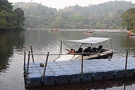
Pookode Lake is a scenic freshwater lake in the Wayanad district in Kerala, South India. A major tourist destination in the district, Pookode is a natural freshwater lake nestling amid evergreen forests and mountain slopes at an altitude of 770 meters above sea level. It is 15 km away from Kalpetta. It is the smallest and highest altitude freshwater lake in Kerala.

College of Veterinary and Animal Sciences is a veterinary college located at Mannuthy, Thrissur city of the Indian state of Kerala. The college is part of Kerala Veterinary and Animal Sciences University.

Lakkidi, Wayanad village in India

Lakkidi is a rain forest located in the gateway of Wayanad district of the Indian state of Kerala.

Panamaram Village in Kerala, India

Panamaram is a village in Wayanad district in the state of Kerala, India..

Pozhuthana is a village in Wayanad district in the state of Kerala, India.

State Highway 29 is a State Highway in Kerala, India that starts at junction of NH 212 at Chundale near Kalpetta and ends in Kerala State Boundary with Tamil Nadu. This highway was originally Kozhikode - Vythiri - State Border and was 97 km long. After the section of the highway from Kozhikode until Chundale became part of NH 212, this highway is now 31.0 km long.

National Highway 766 (India) national highway in India

National Highway 766 is a National Highway in Southern India. NH 766 connects Kozhikode in Kerala with Kollegal in Karnataka via Mysore. Of the total distance of 272 km, 117 km is in Kerala and 155 is in Karnataka. At Kollegal, it joins National Highway 948, which connects Bengaluru and Coimbatore. The highway passes through dense forests of Western ghats of India. The NH-766 passes through Bandipur National Park and other reserve forests. The rapid rise in traffic of vehicles (Automobiles) in this highway has led to deaths of wild animals due to the speeding traffic, even though vehicles are not allowed from 9 P.M to 6 A.M in some stretches.

Meenangadi Town in Kerala, India

Meenangadi is an old town situated on the highway NH 766 between Kalpetta and Sulthan Bathery in Wayanad District, in Kerala, India. This place is one among the Provinces where the existence of Dolmens provide an historical evidence of earlier civilisation. Coffee bean, Black pepper, Ginger, Rice and Areca are the main crops of this area. Meenangadi is famous for its Fish Market,Cattle Market.The nearest railway station is at Kozhikode at 87 Km and airport is Kannur International Airport with 94 Km from Meenangadi. Meenangadi is surrounded by, Ambalavayal Panchayat, Kalpetta Taluk towards west, Gudalur Taluk towards East, Mananthavady Taluk towards west. Kalpetta, Sultan Bathery, Kozhikode are the nearby Cities and towns to Meenangadi.
Kerala's first carbon neutrality project launched in Meenangadi on June 2016. Upon achieving the goals of the project, Meenangadi will be the first village in India to go completely carbon neutral. Meenangadi has a population of 33450 According to 2011 Census with two Villages Purakkadi and (Part)Krishnagiri.

Transportation in Wayanad describes the transportation in Wayanad

The district capital of Wayanad is Kalpetta town. Kalpetta has very good road connectivity with the rest of Kerala and neighboring South Indian cities. National Highway 766 (India) NH766 connects Kalpetta with Kozhikode and Mysore. State Highways connect Kalpetta with Ooty in Tamil Nadu and Madikeri in Karnataka.

Educational Organizations are located mainly in Kalpetta and Sultan Battery.

Krishnagiri Village Village in Kerala, India

Krishnagiri Village is a village in Wayanad District in the state of Kerala, India. It is in a rural area of Wayanad and one of the 15 villages in Sultan Bathery Tehsil.. It is about 16 km (9.9 mi) from Kalpetta and 9 km (5.6 mi) from Sultan Bathery in NH766

References