
The Acadians are the descendants of the French who settled in Acadia during the 17th and 18th centuries. Some are also descended from the Indigenous peoples of the region.

The Bay of Fundy is a bay between the Canadian provinces of New Brunswick and Nova Scotia, with a small portion touching the US state of Maine. It has an extremely high tidal range. The name is likely a corruption of the French word Fendu, meaning "split".

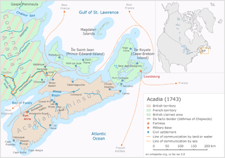
Acadia was a colony of New France in northeastern North America which included parts of eastern Quebec, the Maritime provinces, and Maine to the Kennebec River. During much of the 17th and early 18th centuries, Norridgewock on the Kennebec River and Castine at the end of the Penobscot River were the southernmost settlements of Acadia. The French government specified land bordering the Atlantic coast, roughly between the 40th and 46th parallels. It was eventually divided into British colonies. The population of Acadia included the various indigenous First Nations that comprised the Wabanaki Confederacy, the Acadian people and other French settlers.

The Miꞌkmaq are a First Nations people of the Northeastern Woodlands, indigenous to the areas now known as Canada's Atlantic Provinces and the Gaspé Peninsula of Quebec as well as the northeastern region of Maine. They call their national territory Miꞌkmaꞌki. The nation has a population of about 170,000, of whom nearly 11,000 speak Miꞌkmaq, an Eastern Algonquian language. Once written in Miꞌkmaw hieroglyphic writing, it is now written using most letters of the Latin alphabet.

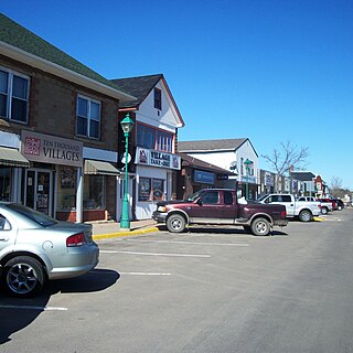
Shediac is a Canadian town in Westmorland County, New Brunswick. The town is known as the "Lobster Capital of the World" and hosts an annual festival every July which promotes its ties to lobster fishing. At the western entrance to the town is a 90-ton sculpture called The World's Largest Lobster.
The Miꞌkmaq language is an Eastern Algonquian language spoken by nearly 11,000 Miꞌkmaq in Canada and the United States; the total ethnic Miꞌkmaq population is roughly 20,000. The native name of the language is Lnuismk, Miꞌkmawiꞌsimk or Miꞌkmwei. The word Miꞌkmaq is a plural word meaning 'my friends' ; the adjectival form is Miꞌkmaw.

Port-Royal National Historic Site is a National Historic Site located on the north bank of the Annapolis Basin in the community of Port Royal, Nova Scotia. The site is the location of the Habitation at Port-Royal.

Escuminac is a rural community in Northumberland County, New Brunswick, Canada. The local service district of Escuminac takes its name from the community.

The Dummer's War was a series of battles between New England and the Wabanaki Confederacy who were allied with New France. The eastern theater of the war was fought primarily along the border between New England and Acadia in Maine, as well as in Nova Scotia; the western theater was fought in northern Massachusetts and Vermont at the border between Canada and New England. During this time, Maine and Vermont were part of Massachusetts.

Amqui is a town in eastern Quebec, Canada, at the base of the Gaspé peninsula in Bas-Saint-Laurent. Located at the confluence of the Humqui and Matapédia Rivers, it is the seat of La Matapédia Regional County Municipality. The main access road is Quebec Route 132.
Petitcodiac is a Canadian village in Westmorland County, New Brunswick.

Atholville is a village in Restigouche County, New Brunswick, Canada.
Eel River Crossing is a Canadian village in Restigouche County, New Brunswick.
The Acadians are the descendants of 17th and 18th century French settlers in parts of Acadia in the northeastern region of North America comprising what is now the Canadian Maritime Provinces of New Brunswick, Nova Scotia and Prince Edward Island, the Gaspé peninsula in eastern Québec, and the Kennebec River in southern Maine. The settlers whose descendants became Acadians primarily came from the southwestern and southern regions of France, historically known as Occitania, while some Acadians are also descended from the Indigenous peoples of the region. Today in certain areas, some may share other ethnic ancestries as well.
Metepenagiag, also known as Red Bank is a Mi'kmaq First Nation band government in New Brunswick, Canada on the other side of the Miramichi river from Sunny Corner.

The history of New Brunswick covers the period from the arrival of the Paleo-Indians thousands of years ago to the present day. Prior to European colonization, the lands encompassing present-day New Brunswick were inhabited for millennia by the several First Nations groups, most notably the Maliseet, Mi'kmaq, and the Passamaquoddy.
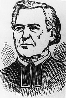
Abbé Jean-Louis Le Loutre was a Catholic priest and missionary for the Paris Foreign Missions Society. Le Loutre became the leader of the French forces and the Acadian and Mi'kmaq militias during King George's War and Father Le Loutre's War in the eighteenth-century struggle for power between the French, Acadians, and Miꞌkmaq against the British over Acadia.
Father Le Loutre's War (1749–1755), also known as the Indian War, the Micmac War and the Anglo-Micmac War, took place between King George's War and the French and Indian War in Acadia and Nova Scotia. On one side of the conflict, the British and New England colonists were led by British Officer Charles Lawrence and New England Ranger John Gorham. On the other side, Father Jean-Louis Le Loutre led the Mi'kmaq and the Acadia militia in guerrilla warfare against settlers and British forces.

Bouctouche is a Canadian town in Kent County, New Brunswick. In 2016, the population was 2,361.
The Maliseet militia were made up of warriors from the Maliseet people of northeastern North America. Along with the Wabanaki Confederacy, the French and Acadian militia, the Maliseet fought the British through six wars over a period of 75 years. They also mobilized against the British in the American Revolution. After confederation, Mi'kmaq warriors eventually joined Canada's war efforts in World War I and World War II.
