Princeton, North Carolina

Last updated

Princeton, North Carolina
Princeton, North Carolina.jpg
NCMap-doton-Princeton.PNG
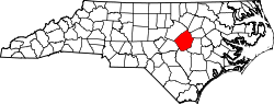
Location of Princeton, North Carolina
Coordinates: 35°28′00″N78°09′41″W / 35.46667°N 78.16139°W / 35.46667; -78.16139
Country United States
State North Carolina
County Johnston
Government
  Mayor Stacy G. Johnson
Area
[1]
  Total
1.16 sq mi (3.00 km2)
  Land1.16 sq mi (3.00 km2)
  Water0 sq mi (0.00 km2)
Elevation
[2]
151 ft (46 m)
Population
 (2020)
  Total
1,315
  Density1,134.5/sq mi (438.05/km2)
Time zone UTC-5 (Eastern (EST))
  Summer (DST) UTC-4 (EDT)
ZIP code
27569
Area code 919
FIPS code 37-53820 [3]
GNIS feature ID2407161 [2]
Website www.myprincetonnc.com

Princeton is a town in Johnston County, North Carolina, United States. As of the 2010 census it had a population of 1,194. [4] Each May the town celebrates Princeton Community Day, a festival dedicated to promoting community involvement and town pride. The town holds municipal elections in November in odd-number years to elect its mayor and town council.

Contents

History

Princeton was incorporated as the town of Boon Hill in 1861, named in homage to the nearby Boon family plantation. It was renamed Princeton in 1873. [5] In 1914 the Gurley Mill was constructed as a corn and feed mill. By 2020 it was the oldest structure in Princeton, until it burned down in November. [6] The Princeton Graded School is listed on the National Register of Historic Places. [7]

Geography

Princeton is in eastern Johnston County. US 70 runs along the northern edge of the town, leading northwest 9 miles (14 km) to I-95 near Selma and southeast 11 miles (18 km) to Goldsboro.

According to the United States Census Bureau, the town has a total area of 1.0 square mile (2.7 km2), all land. [4]

Demographics

Historical population
CensusPop.Note
1890 248
1900 28113.3%
1910 35426.0%
1920 40313.8%
1930 50926.3%
1940 5120.6%
1950 60818.8%
1960 94855.9%
1970 1,04410.1%
1980 1,034−1.0%
1990 1,18114.2%
2000 1,066−9.7%
2010 1,19412.0%
2020 1,31510.1%
U.S. Decennial Census [8]

2020 census

Princeton racial composition [9]
RaceNumberPercentage
White (non-Hispanic)83063.12%
Black or African American (non-Hispanic)31924.26%
Native American 20.15%
Asian 80.61%
Pacific Islander 10.08%
Other/Mixed 544.11%
Hispanic or Latino 1017.68%

As of the 2020 United States census, there were 1,315 people, 497 households, and 246 families residing in the town.

2010 census

As of the census [10] of 2010, there were 1,194 people, 502 households, and 320 families residing in the town. The population density was 1,705.7 inhabitants per square mile (658.6/km2). There were 571 housing units at an average density of 815.7 per square mile (314.9/km2). The racial makeup of the town was 67.2% White, 25.5% African American, 5.6% from other races, and 1.7% from two or more races. Hispanic or Latino of any race were 5.9% of the population.

There were 502 households, out of which 28.0% had children under the age of 18 living with them, 41.6% were married couples living together, 18.5% had a female householder with no husband present, and 36.3% were non-families. 31.7% of all households were made up of individuals, and 15.3% had someone living alone who was 65 years of age or older. The average household size was 2.38 and the average family size was 3.00.

In the town, the population was spread out, with 26.0% under the age of 18, 8.5% from 18 to 24, 24.7% from 25 to 44, 23.6% from 45 to 64, and 17.3% who were 65 years of age or older. The median age was 38.4 years. For every 100 females, there were 76.6 males. For every 100 females age 18 and over, there were 74.4 males age 18 and over.

The median income for a household in the town was $32,143, and the median income for a family was $38,063. Males had a median income of $26,726 versus $20,690 for females. The per capita income for the town was $17,116. About 26.5% of families and 30.1% of the population were below the poverty line, including 56.3% of those under age 18 and 12.5% of those age 65 or over.

Education

References

  1. "ArcGIS REST Services Directory". United States Census Bureau. Retrieved September 20, 2022.
  2. 1 2 U.S. Geological Survey Geographic Names Information System: Princeton, North Carolina
  3. "U.S. Census website". United States Census Bureau . Retrieved January 31, 2008.
  4. 1 2 "Geographic Identifiers: 2010 Census Summary File 1 (G001): Princeton town, North Carolina". American Factfinder. U.S. Census Bureau. Archived from the original on February 13, 2020. Retrieved October 12, 2018.
  5. Powell 1976, p. 396.
  6. "Fire engulfs Princeton's oldest building, cause remains unknown". WRAL-TV. Capitol Broadcasting Company. November 18, 2020. Retrieved November 25, 2021.
  7. "National Register Information System". National Register of Historic Places . National Park Service. July 9, 2010.
  8. "Census of Population and Housing". Census.gov. Retrieved June 4, 2015.
  9. "Explore Census Data". data.census.gov. Retrieved December 23, 2021.
  10. 2010 Census Fact Finder Data Retrieved on September 12, 2013.

Works cited