
Val Verde County is a county located on the southern Edwards Plateau in the U.S. state of Texas. The 2014 population is 51,047. Its county seat is Del Rio. In 1936, Val Verde County received Recorded Texas Historic Landmark number 5625 to commemorate its founding.

Boa Vista, also written as Boavista, is a desert-like island that belongs to the Cape Verde Islands. At 631.1 km2 (243.7 sq mi), it is the third largest island of the Cape Verde archipelago.

Calheta de São Miguel is a city in the northern part of the island of Santiago, Cape Verde. In 2010 its population was 3,175. It is situated on the east coast, 31 km north of the capital Praia. It is the seat of São Miguel municipality.
Pedra Badejo is a city in the eastern part of the island of Santiago, Cape Verde. It is situated on the east coast, 25 km north of the island capital Praia, 8 km southeast of Calheta de São Miguel and 15 km east of Assomada. It is the seat of Santa Cruz municipality. At the 2010 census, the town had 9,859 inhabitants.

Ribeira da Barca is a town in the municipality of Santa Catarina, on the island of Santiago, Cape Verde. In 2010 its population was 2,317. It is situated on the west coast, at the mouth of the stream Ribeira da Barca, 11 km northwest of Assomada. The settlement was mentioned as "Rivera das Baras" in the 1747 map by Jacques-Nicolas Bellin.

Achada Monte is a town in the northern part of the island of Santiago, Cape Verde and is part of the municipality of São Miguel. It is situated near the east coast, 8 km northwest of Calheta de São Miguel. In 2010 its population was 1,652. It is on the road connecting Praia and Tarrafal through Pedra Badejo, the EN1-ST02. The small bay Mangue de Sete Ribeiras is located east of the settlement. Ribeira Principal flows west of the village.
Figueira das Naus is a settlement in the western part of the island of Santiago, Cape Verde. It is part of the municipality of Santa Catarina. In 2010 its population was 1,157. It is situated 11 km south of Tarrafal and 12 km northwest of Assomada. It is situated on the secondary road connecting Fundura and Ribeira da Prata.
Ponta Verde is a town in the northwestern part of the island of Fogo, Cape Verde. In 2010 its population was 1,072. It is situated 11 km northeast of the island capital São Filipe.
Água de Gato is a settlement in the central part of the island of Santiago, Cape Verde. In 2010 its population was 957. It is situated at about 400 m elevation, 2 km northwest of São Domingos and 2 km east of Rui Vaz.

Pombas is a city in the northeastern part of the island of Santo Antão, Cape Verde. It is the seat of the municipality Paul. It is situated on the coast, at the mouth of the Ribeira do Paul, 7 km (4.3 mi) southeast of Ribeira Grande and 15 km (9.3 mi) north of the island capital Porto Novo. The national roads EN1-SA02 and EN1-SA03 connect Pombas with Ribeira Grande and Porto Novo, respectively. Pombas was elevated from town to city in 2010.
Praia Branca is a town in the northwestern part of the island of São Nicolau, Cape Verde. It is part of the municipality of Tarrafal de São Nicolau. Its population at the 2010 census was 521. It is situated 2 km from the coast, 10 km northwest of Ribeira Brava.
Morro is a settlement in the west of the island of Maio in Cape Verde. It is located 5 km north of the island capital Porto Inglês and 6 km south of Calheta. As of the 2010 census, its population was 310. The beach north of the village, Praia do Morro, is a 6.66 km2 nature reserve.

São Jorge is a settlement in the central part of the island of Santiago, Cape Verde. It is part of the São Lourenço dos Órgãos municipality. In 2010 its population was 6. It is situated 2.5 km southwest of João Teves and 4 km southeast of Picos. Its elevation is 319 meters.

São Domingos is a city in the central part of the island of Santiago, Cape Verde. In 2010 its population was 2,818. It is the seat of the São Domingos Municipality. It is situated 13 km southeast of Assomada and 13 km northwest of the capital Praia, along the national road from Praia to Assomada (EN1-ST01). The settlement appeared in the 1747 map by Jacques-Nicolas Bellin as St. Domingo.
Salineiro is a village in the southern part of the island of Santiago, Cape Verde. It is part of the municipality of Ribeira Grande de Santiago. In 2010 its population was 1,113. It is located on the western edge of the Ribeira Grande gorge, 2.5 km north of Cidade Velha and 11 km west of the capital Praia.
Praia Baixo is a village in the southeastern part of the island of Santiago, Cape Verde. It is part of the municipality of São Domingos and the parish of Nossa Senhora da Luz. It is situated on the east coast, 1.5 km northwest of Achada Baleia, 11 km southeast of Pedra Badejo, 10 km east of São Domingos and 16 km north of the capital Praia. In 2010 its population was 952.
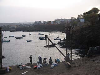
São Martinho Grande is a settlement in the southern part of the island of Santiago, Cape Verde. It is part of the municipality Ribeira Grande de Santiago. It is located 4 km east from Cidade Velha and 6.5 km west of Praia city centre. The national road EN1-ST05 passes north of the village. 1.5 km south of the village is a small bay of the Atlantic Ocean, Calheta de São Martinho. It was mentioned as "Kalyete de S. Martin" on the 1747 map by Jacques-Nicolas Bellin.
Belém is a settlement in the southwest of the island of Santiago, Cape Verde. It is part of the municipality of Ribeira Grande de Santiago. It is 2 km west of Santana, 6 km north of Porto Gouveia and 11 km northwest of the municipal seat Cidade Velha. In 2010 its population was 382.


