
Jacob August Riis was a Danish-American social reformer, "muck-raking" journalist, and social documentary photographer. He contributed significantly to the cause of urban reform in the United States of America at the turn of the twentieth century. He is known for using his photographic and journalistic talents to help the impoverished in New York City; those impoverished New Yorkers were the subject of most of his prolific writings and photography. He endorsed the implementation of "model tenements" in New York with the help of humanitarian Lawrence Veiller. He was an early proponent of the newly practicable casual photography and one of the first to adopt photographic flash. While living in New York, Riis experienced poverty and became a police reporter writing about the quality of life in the slums. He attempted to alleviate the poor living conditions of poor people by exposing these conditions to the middle and upper classes.

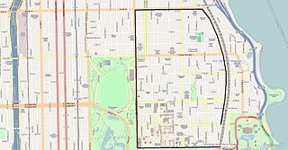
Logan Square is an official community area, historical neighborhood, and public square on the northwest side of the City of Chicago. The Logan Square community area is one of the 77 city-designated community areas established for planning purposes. The Logan Square neighborhood, located within the Logan Square community area, is centered on the public square that serves as its namesake, located at the three-way intersection of Milwaukee Avenue, Logan Boulevard and Kedzie Boulevard.

Chatham is one of the 77 community areas of Chicago, Illinois, on the city's South Side. It includes the neighborhoods of Chatham-Avalon, Chatham Club, Chesterfield, East Chatham, West Chatham and the northern portion of West Chesterfield. Its residents are predominantly African American, and it is home to former Senator Roland Burris. Housing many city employees and other officials, Chatham has been a central area for Chicago's middle-class African Americans since the late 1950s.

Massachusetts Avenue is a major diagonal transverse road in Washington, D.C., and the Massachusetts Avenue Historic District is a historic district that includes part of it.
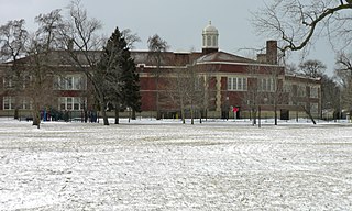
The Norwood Park Historical District is a historic district in the Norwood Park neighborhood of Chicago, Illinois. It is bordered by Bryn Mawr, Avondale, and Harlem Avenues, and is home to the Noble-Seymour-Crippen House, which was built in 1833 and is widely considered to be the oldest house in Chicago. The historic district is also home to Norwood Park Public School, William Howard Taft High School, Norwood Park, Myrtle Park, and Norwood Circle Park. The district was added to the National Register of Historic Places in 2002.

The J. J. Walser Jr. House in the Chicago, Illinois, neighborhood of Austin was designed by Frank Lloyd Wright for real estate developer Joseph Jacob Walser Jr. The cruciform two-story house is typical of Wright's Prairie School period.
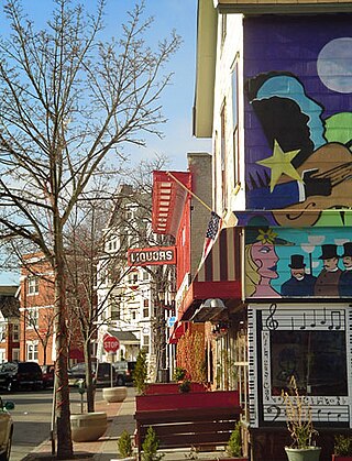
The Allentown district is a neighborhood in Buffalo, New York. The neighborhood is home to the Allentown Historic District.

Jacob Riis Park, also called Jacob A. Riis Park and Riis Park, is a seaside park on the southwestern portion of the Rockaway Peninsula in the New York City borough of Queens. It lies at the foot of the Marine Parkway–Gil Hodges Memorial Bridge, east of Fort Tilden, and west of Neponsit and Rockaway Beach. Originally run by the New York City Department of Parks and Recreation, it later became part of the Jamaica Bay Unit of the Gateway National Recreation Area, and is managed by the National Park Service (NPS). It features an extensive sand beach along the Atlantic Ocean coastline and several historic Art Deco structures.

The Lummus Park Historic District or simply Lummus Park, is on the National Register of Historic Places and a locally historic designated district in Miami, Florida. It is roughly bound by Northwest Fifth Street to the north, Flagler Street to the south, Northwest Third Avenue to the east, and the Miami River to the west. On October 25, 2006, it was added to the U.S. National Register of Historic Places. Lummus Park has some of the oldest structures in Miami, and over the decades, has been able to retain a large part of its early pioneer character.

The Old Chicago Water Tower District is a historic district along the Magnificent Mile shopping district in the Near North Side community area of Chicago, Illinois. The district is located on both sides of North Michigan Avenue between East Chicago and East Pearson Streets. It includes the Chicago Water Tower, Chicago Avenue Pumping Station, and Chicago Fire Department Fire Station No. 98. All three structures are part of the Chicago Landmark district designated on October 6, 1971. The Water Tower and Pumping Station were jointly added to the National Register of Historic Places on April 23, 1975. In addition the Tower was named an American Water Landmark in 1969. The Water Tower was also one of the few buildings to survive the Great Chicago Fire. The district is the namesake of the nearby Water Tower Place.

The Kenilworth Avenue Historic District is a historic district in the northwestern portion of Dayton, Ohio, United States. Composed largely of houses constructed after the Great Flood of 1913, the district features examples of several prominent architectural styles, and it has received both local and federal recognition.

The Villa District, also known as Villa Historic District, is a historic district in Chicago, Illinois, United States. It is located on Chicago's Northwest Side within the community area of Irving Park. Its borders are along Pulaski Road to the west, the Union Pacific/Northwest rail line to the north, Hamlin Avenue to the east, and Addison Street to the south. Located directly north of the Wacławowo area of Avondale, the Villa District is serviced by the Blue Line's Addison street station.

The Church of the Resurrection is a historic Episcopal church and rectory in Richmond Hill, Queens, New York City. It was originally built in 1874 as a frame, Gothic Revival style church. It was extensively remodeled and enlarged in 1904 in the Late Gothic / Tudor Revival style. It has an exterior of random quarry-faced stone and a prominent bell tower with spire. The church includes the Riis family memorial window, donated in 1905 by Elizabeth Riis, wife of Jacob Riis. The adjacent Cummings Hall was built in 1923. The rectory was built in 1888 and is a 2+1⁄2-story, frame dwelling with a hipped roof and gable dormers in the Queen Anne style.
Prairie Avenue is a north–south street on the South Side of Chicago, which historically extended from 16th Street in the Near South Side to the city's southern limits and beyond. The street has a rich history from its origins as a major trail for horseback riders and carriages. During the last three decades of the 19th century, a six-block section of the street served as the residence of many of Chicago's elite families and an additional four-block section was also known for grand homes. The upper six-block section includes part of the historic Prairie Avenue District, which was declared a Chicago Landmark and added to the National Register of Historic Places.
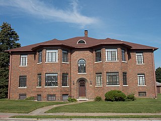
Columbia Avenue Historic District is located in the central part of the city of Davenport, Iowa, United States. It was listed on the National Register of Historic Places in 1984. The district lies north and west of Vander Veer Park. The area is entirely residential and it contains brick apartment buildings that were built between 1930 and 1939. It is one of the city's smallest districts and it is unique among the other historic districts in that it contains primarily apartment buildings.

General Winfield Scott Hancock is an equestrian statue of Winfield Scott Hancock, by Henry Jackson Ellicott together with architect Paul J. Pelz. It is located at Pennsylvania Avenue in United States Navy Memorial Park at the northwest corner of 7th Street, Northwest, Washington, D.C.
Hyde Park–Kenwood Historic District is a National Register of Historic Places (NRHP) district on the South Side of Chicago that includes parts of the Hyde Park and Kenwood community areas of Chicago, Illinois. The northern part of this district overlaps with the officially designated Chicago Landmark Kenwood District. This northern part of the Hyde Park–Kenwood Historic District contains the Chicago home of Barack Obama. The entire district was added to the NRHP on February 14, 1979, and expanded on August 16, 1984, and May 16, 1986. The district is bounded to the north, south, east and west, respectively by 47th Street, 59th Street, Lake Park Avenue and Cottage Groves Avenue. Despite the large amount of property associated with the University of Chicago, the Hyde Park–Kenwood Historic District is mostly residential. The district is considered to be significant for its architecture and education.

The historic Chicago park and boulevard system is a ring of parks connected by wide, planted-median boulevards that winds through the north, west, and south sides of the City of Chicago. Neighborhoods along this historic stretch include Logan Square, Humboldt Park, Garfield Park, Lawndale, Little Village, McKinley Park, Brighton Park, Gage Park, Englewood, Back of the Yards, and Bronzeville. It reaches as far west as Garfield Park and turns south east to Douglass Park. In the south, it reaches Washington Park and Jackson Park, including the Midway Plaisance, used for the 1893 World's Fair.
The West Side Third Avenue SW Commercial Historic District is a nationally recognized historic district located in Cedar Rapids, Iowa, United States. It was listed on the National Register of Historic Places in 2014. At the time of its nomination it consisted of 10 resources, which included seven contributing buildings and three non-contributing buildings. Cedar Rapids was platted on the east bank of the Cedar River as Rapids City in 1841, and it was incorporated in 1849. Kingston was established on the west bank of the river in 1852, and it was annexed by Cedar Rapids in 1870. The streets were laid out parallel and perpendicular to the river, which flowed from the northwest to the southeast. The Chicago, Iowa & Nebraska Railway, later the Chicago & North Western Railway, was the prominent railroad on the west side of town. The first bridge across the river at Third Avenue was built in 1871. The current bridge was completed in 1912. Prior to a bridge, Rapid City and Kingston were connected by a ferry operated by David W. King, the founder of Kingston.


