
Garfield Park is a 184-acre (0.74 km2) urban park located in the East Garfield Park neighborhood on Chicago's West Side. It was designed as a pleasure ground by William LeBaron Jenney in the 1870s and is the oldest of the three original parks developed by the West Side parks commission on the Chicago park and boulevard plan. It is home to the Garfield Park Conservatory, one of the largest plant conservatories in the United States. It is also the park furthest west in the Chicago park and boulevard system.

Chatham is one of the 77 community areas of Chicago, Illinois, on the city's South Side. It includes the neighborhoods of Chatham-Avalon, Chatham Club, Chesterfield, East Chatham, West Chatham and the northern portion of West Chesterfield. Its residents are predominantly African American, and it is home to former Senator Roland Burris. Housing many city employees and other officials, Chatham has been a central area for Chicago's middle-class African Americans since the late 1950s.

Greater Grand Crossing is one of the 77 community areas of Chicago, Illinois. It is located on the city's South Side.

Calumet Park is a 198-acre (79-hectare) urban park in Chicago, Illinois. Providing access to Lake Michigan from the East Side neighborhood on the city's Southeast Side, the park contains approximately 0.9 miles (1.5 km) of lake frontage from 95th Street to 102nd Street, which extends to the city limits, the Illinois' border with Indiana. The park is listed on the National Register of Historic Places.

Portage Park is a 36-acre (15 ha) park in the Portage Park community area of Chicago, Illinois on the National Register of Historic Places. The park stretches from Irving Park Road on the south to Berteau Avenue between Central and Long Avenues. The largest public park on Chicago's Northwest Side, it has many recreational facilities including six tennis courts, two playgrounds, a slab for in-line skating, a bike path, a nature walk, five baseball fields, two combination football/soccer fields and two fieldhouses— one housing a gymnasium and the other a cultural arts building. The park also has an Olympic-size pool featuring a large deck for sunning, misting sprays, as well as an interactive water play area with slide and diving boards in addition to a smaller heated pool. Plans are currently underway for the development of a new, 6,500-square-foot (600 m2) senior center at Portage Park.

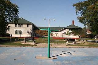
Jefferson Park is a 7-acre (2.8 ha) park in the Jefferson Park community area of Chicago, Illinois on the National Register of Historic Places.

Indian Boundary Park is a 13-acre (5.3 ha) urban park in the West Ridge neighborhood of North Side, Chicago, Illinois.
Prairie Avenue is a north–south street on the South Side of Chicago, which historically extended from 16th Street in the Near South Side to the city's southern limits and beyond. The street has a rich history from its origins as a major trail for horseback riders and carriages. During the last three decades of the 19th century, a six-block section of the street served as the residence of many of Chicago's elite families and an additional four-block section was also known for grand homes. The upper six-block section includes part of the historic Prairie Avenue District, which was declared a Chicago Landmark and added to the National Register of Historic Places.

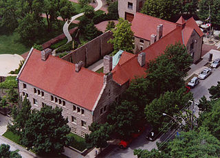
Pulaski Park is a park in the West Town neighborhood of Chicago, Illinois. It was founded in 1912, and was named after American Revolutionary War hero Casimir Pulaski.

Austin Town Hall Park is a park at 5610 W. Lake Street in the Austin neighborhood of Chicago, Illinois. The site was formerly used for the town hall of Cicero Township. The Austin subdivision of Cicero was annexed to the City of Chicago in 1899, and the town hall site eventually became part of the Chicago Park District. The park's fieldhouse, designed by Michaelsen and Rognstad in the 1920s, is influenced largely by Philadelphia's Independence Hall.
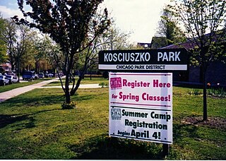
Kosciuszko Park is a park located at 2732 N. Avers Ave. Situated along the northern boundary of Chicago's Logan Square community area at Diversey, it is heavily frequented by residents of Avondale and is considered to be part of Jackowo.

Sherman Park is a sixty-acre park in the New City neighborhood of South Side, Chicago.

The Shedd Park Fieldhouse is the historic fieldhouse in Shedd Park, a public park in the South Lawndale community area of Chicago, Illinois. John G. Shedd, for whom the park and fieldhouse are named, gave the city the land for the park. The Prairie School building was designed by William Drummond and built in 1917. The brown brick building features limestone trim. A Prairie School gymnasium designed by Michaelsen and Rognstad was added to the building in 1928.

Hamilton Park is a public park at 513 W. 72nd Street in the Englewood neighborhood of Chicago, Illinois. The park opened in 1904 as part of a plan led by the South Park Commission to add small neighborhood parks on Chicago's South Side. It was the first public park in Englewood. Landscape designers the Olmsted Brothers and architecture firm D. H. Burnham & Company collaborated on the park's design. The park opened with a fieldhouse, baseball field, wading pool, and walkways; within the decade, the designers added gymnasiums, a playground, and tennis courts. The fieldhouse has a Beaux-Arts design, and its inside features several murals of prominent figures in American history. The park was heavily used after it opened, and the fieldhouse in particular was booked so consistently that it was expanded in the 1920s.
Trumbull Park is a public park at 2400 E. 105th Street in the South Deering neighborhood of Chicago, Illinois. The South Park Commission opened the park in 1907 as part of its efforts to bring parks to dense immigrant neighborhoods with little green space. The park's fieldhouse and other facilities were not completed until the 1910s; around this time, the park was officially named for Lyman Trumbull, a United States senator from Illinois who co-wrote the Thirteenth Amendment. While the park and its facilities were designed in-house by the South Park Commission, they were inspired by the designs of landscape architects the Olmsted Brothers and architecture firm D. H. Burnham and Company used in many of the South Park Commission's other parks. The fieldhouse in particular has a Beaux-Arts design which calls back to Burnham's work for the 1893 Columbian Exposition.
Fuller Park is a public park at 331 W. 45th Street in the neighborhood of the same name in Chicago, Illinois, United States. The park was one of several built by the South Park Commission in the early 20th century to provide parks in dense and poor South Side Chicago neighborhoods which lacked them. While most of the South Park Commission parks opened in the mid-1900s, work on Fuller Park did not begin until 1910 due to a dispute over its location, and its facilities gradually opened over the next four years. The park was named for Melville Fuller, an Illinois native and former Chief Justice of the United States. The South Park Commission designed the park's landscape in a similar style to their earlier parks, which had been designed by the Olmsted Brothers; D. H. Burnham and Company designed its buildings, as they had for the earlier parks. The park originally included a Beaux-Arts fieldhouse, a gymnasium, a bathhouse, a grandstand, and a running track and walking paths. Fuller Park was first settled by Irish immigrants in the later 1860s after the Union Stock Yards opened on Christmas Day 1865. This area became a part of the Lake Township area and after the Great Chicago Fire of 1871 and the opening of the Lake Shore & Michigan Southern Railroad the area flourished into a community.

Davis Square is a public park located between 44th and 45th Streets and Marshfield and Hermitage Avenues in the New City community area of Chicago, Illinois. The park opened in 1905 as one of the initial parks in the South Park Commission's plan to build parks in the dense, poor neighborhoods of Chicago's South Side. It was named for Nathan Smith Davis, a Chicago physician and one of the founders of the American Medical Association. As they did for most of the South Park Commission's parks, the Olmsted Brothers designed Davis Square's landscape, while D. H. Burnham and Company designed its facilities. The park initially included a Beaux-Arts styled fieldhouse, a swimming pool and pool house, baseball fields, and walking paths.

The South Park Manor Historic District is a residential historic district in the Greater Grand Crossing neighborhood of Chicago, Illinois. The district includes 263 Chicago bungalows built between 1915 and 1927. At the time, single-family homeownership was becoming broadly accessible to Chicagoans, and the bungalow was a popular choice for dense urban housing. The bungalows in the district were designed by several developers, but the district has a consistent appearance nonetheless. The use of a single home type throughout provided uniformity to the neighborhood, while stylistic variations such as the placement of dormers and porches gave each house its own character. The developers also gave their homes spacious lawns and private backyards to preserve green space in an urban setting.
Cornell Square is a public park at 1809 W. 50th Street in the New City community area of Chicago, Illinois. Opened in 1905, the park was one of many planned by the South Park Commission to provide parks in dense, poor South Side neighborhoods. The park was named for Paul Cornell, one of the Commission's board members. As with the South Park Commission's other early parks, landscape architects the Olmsted Brothers designed the park's layout while D. H. Burnham and Company designed its facilities. The park originally included a fieldhouse with gymnasium facilities, a swimming pool, athletic fields, and walking paths. The fieldhouse has a Beaux-Arts design and includes a painting of Ezra Cornell, the founder of Cornell University and Paul Cornell's cousin.

The William Hall Walker Gymnasium is an athletic facility on the campus of the Stevens Institute of Technology in the City of Hoboken in Hudson County, New Jersey. It is located near Sixth Street on Fieldhouse Road in the Castle Point section of the city. Built from 1915 to 1916, the building was added to the National Register of Historic Places on May 9, 2019, for its significance in architecture.


