Palmer Park (Chicago)

Last updated

Palmer Park
Palmer Park Fieldhouse.jpg
Chicago locator map.png
Red pog.svg
USA Illinois location map.svg
Red pog.svg
Usa edcp location map.svg
Red pog.svg
Location201 E. 111th St., Chicago, Illinois 60628
Area40.5 acres (16.4 ha)
ArchitectD.H Burnham and Co.; Olmstead Bros
Architectural style Beaux-Arts
MPS Chicago Park District MPS
NRHP reference # 07000855 [1]
Added to NRHPAugust 30, 2007

Palmer Park is an urban park at 201 E. 111th Street on the far South Side of Chicago, Illinois, USA.

Urban park park in a city or other incorporated place

An urban park or metropolitan park, also known as a municipal park or a public park, public open space, or municipal gardens (UK), is a park in cities and other incorporated places to offer recreation and green space to residents of, and visitors to, the municipality. The design, operation and maintenance is usually done by government agencies, typically on the local level, but may occasionally be contracted out to a park conservancy, friends of group, or private sector company.

Contents

History

Palmer Park was created in 1904 by the South Park Commission. Under the guidance of superintendent J. Frank Foster, the commission opened ten new neighborhood parks, including Palmer Park, in an effort to create breathing space and recreational areas in the city's crowded tenement districts. These parks were built by Olmsted Brothers landscape architects and D.H. Burnham and Co. architects. [2] The park is named for Potter Palmer, a successful businessman and real estate investor concerned with the development of Chicago. [2] Palmer was responsible for reclaiming the acres of swampland north of the city's business district, which were developed into the Lake Shore Drive area. He built the original baseball field for the Cubs' predecessor, the Chicago White Stockings, and built the Palmer House Hotel.

Tenement multi-occupancy building

A tenement is a multi-occupancy building of any sort. In Scotland it refers to flats divided horizontally in an established building type, including desirable properties in affluent areas, but in other countries the term often refers to a run-down apartment building or slum building.

Landscape architecture design of outdoor public areas, landmarks, and structures to achieve environmental, social-behavioral, or aesthetic outcomes

Landscape architecture is the design of outdoor areas, landmarks, and structures to achieve environmental, social-behavioural, or aesthetic outcomes. It involves the systematic investigation of existing social, ecological, and soil conditions and processes in the landscape, and the design of interventions that will produce the desired outcome. The scope of the profession includes landscape design; site planning; stormwater management; erosion control; environmental restoration; parks and recreation planning; visual resource management; green infrastructure planning and provision; and private estate and residence landscape master planning and design; all at varying scales of design, planning and management. A practitioner in the profession of landscape architecture is called a landscape architect.

Potter Palmer American businessman

Potter Palmer was an American businessman who was responsible for much of the development of State Street in Chicago. Born in Albany County, New York, he was the fourth son of Benjamin and Rebecca (Potter) Palmer.

In 1934, the city's 22 independent park commissions were consolidated into a new unified system, and Palmer Park became park of the Chicago Park District. Park district art director James McBurney painted three murals for Palmer Park as a Works Progress Administration project with money from the federal government. The three are: "Native Americans," "Explorers," and "Dutch settlers." Other noteworthy McBurney murals are found at the Wentworth School, Tilden High School, and Woodlawn National Bank. [2]

Chicago Park District

The Chicago Park District is the oldest and one of the largest park districts in the United States. As of 2016, there are over 600 parks included in the Chicago Park District as well as 27 beaches, several boat harbors, two botanic conservatories, a zoo, and 11 museums. The Chicago Park District also has more than over 230 field houses, 78 public pools, and dozens of sports and recreational facilities, with year-round programming. The district is an independent taxing authority as defined by Illinois State Statute and is considered a separate agency of the City of Chicago. The district's general superintendent and CEO, Michael P. Kelly, was appointed by the mayor of Chicago and confirmed by the board of commissioners in 2011. The district's headquarters are located in the Time-Life Building in the Streeterville neighborhood.

Works Progress Administration United States federal New Deal agency charged with creating work in the 1930s and 1940s

The Works Progress Administration was an American New Deal agency, employing millions of job-seekers to carry out public works projects, including the construction of public buildings and roads. It was established on May 6, 1935, by Executive Order 7034. In a much smaller project, Federal Project Number One, the WPA employed musicians, artists, writers, actors and directors in large arts, drama, media, and literacy projects. The four projects dedicated to these were: the Federal Writers’ Project (FWP), the Historical Records Survey (HRS), the Federal Theatre Project (FTP), the Federal Music Project (FMP), and the Federal Art Project (FAP). In the Historical Records Survey, for instance, many former slaves in the South were interviewed; these documents are of great importance for American history. Theater and music groups toured throughout America, and gave more than 225,000 performances. Archaeological investigations under the WPA were influential in the rediscovery of pre-Columbian Native American cultures, and the development of professional archaeology in the US.

Facilities

The park, located just south of Gwendolyn Brooks College Preparatory Academy is open daily from dawn to dusk, with free admission. Facilities at the park include baseball fields, an indoor gym, meeting rooms, an outdoor swimming pool, and tennis courts. [2]

Gwendolyn Brooks College Preparatory Academy

Gwendolyn Brooks College Preparatory Academy is a public selective enrollment 4-year magnet high school located in the Roseland community area on the far south side of Chicago, Illinois, United States. It is operated by Chicago Public Schools. A university-preparatory school, it is named for African-American poet Gwendolyn Brooks.

Baseball team sport

Baseball is a bat-and-ball game played between two opposing teams who take turns batting and fielding. The game proceeds when a player on the fielding team, called the pitcher, throws a ball which a player on the batting team tries to hit with a bat. The objective of the offensive team is to hit the ball into the field of play, allowing it to run the bases—having its runners advance counter-clockwise around four bases to score what are called "runs". The objective of the defensive team is to prevent batters from becoming runners, and to prevent runners' advance around the bases. A run is scored when a runner legally advances around the bases in order and touches home plate. The team that scores the most runs by the end of the game is the winner.

Tennis Ball sport with racket and net

Tennis is a racket sport that can be played individually against a single opponent (singles) or between two teams of two players each (doubles). Each player uses a tennis racket that is strung with cord to strike a hollow rubber ball covered with felt over or around a net and into the opponent's court. The object of the game is to maneuver the ball in such a way that the opponent is not able to play a valid return. The player who is unable to return the ball will not gain a point, while the opposite player will.

Related Research Articles

Jackson Park (Chicago) Park in Chicago

Jackson Park is a 500-acre (2 km²) park located at 6401 South Stony Island Avenue in the Woodlawn community on the South Side in Chicago, Illinois. It extends into the South Shore and Hyde Park nearby neighborhoods, bordering onto Lake Michigan and several other South Side neighborhoods. Named for Seventh President Andrew Jackson, it is one of two Chicago Park District parks with the name "Jackson", the other being Mahalia Jackson Park for the gospel music singer in the Auburn Gresham community on the far southwest side of Chicago.

Lincoln Park park along the lakefront of Chicago, Illinois North Side

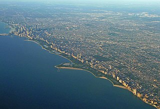
Lincoln Park is a 1,208-acre (489-hectare) park situated along Lake Michigan on the North Side of Chicago, Illinois. Named after US President Abraham Lincoln, it is the city's largest public park and stretches for seven miles (11 km) from Grand Avenue on the south to near Ardmore Avenue on the north, just north of the Lake Shore Drive terminus at Hollywood Avenue. Several museums and a zoo are located between North Avenue and Diversey Parkway in the eponymous neighborhood. Further to the north, the park is characterized by parkland, beaches, recreational areas, nature reserves, and harbors. To the south, there is a more narrow strip of beaches east of Lake Shore Drive, almost to downtown. With 20 million visitors per year, Lincoln Park is the second-most-visited park in the United States.

Marshall Field's was a department store in Chicago, Illinois, that grew to become a chain before being acquired by Macy's, Inc in 2005.

State Street (Chicago) street in Chicago, Illinois

State Street is a large south-north street in Chicago, Illinois, USA and its south suburbs. It begins at North Avenue, the south end of Lincoln Park, runs south through the heart of Downtown Chicago, and ends at the southern city limits, intersecting 127th Street along the bank of the Little Calumet River. It resumes north of 137th Street in Riverdale and runs south intermittently through Chicago's south suburbs until terminating at New Monee Road in Crete, Illinois. Its intersection with Madison Street has marked the base point for Chicago's address system since 1909.

Museum Campus human settlement in Chicago, Illinois, United States of America

Museum Campus is a 57-acre (23 ha) park in Chicago that sits alongside Lake Michigan in Grant Park and encompasses five of the city's most notable attractions: the Adler Planetarium, America's first planetarium; the Shedd Aquarium; the Field Museum of Natural History; Soldier Field, home of the NFL Chicago Bears football team; and the Lakeside Center of McCormick Place. Museum Campus sits adjacent to Northerly Island along the waterfront.

Marquette Park (Chicago)

Marquette Park, the largest park on the southwest side of Chicago, Illinois, at 323 acres (1.31 km2), is located at 41.768°N 87.703°W in the city's Chicago Lawn neighborhood. The park is named for Father Jacques Marquette (1637–1675).

The Rayen School was a public high school in Youngstown, Ohio, United States. At the time it was closed in 2007, it was the oldest of the three high schools in the city. The high school's most recent physical plant opened in 1923, when the institution was relocated from a 19th-century structure located at 120 W Wood Street in Youngstown that currently houses Youngstown's Board of Education.

Bessemer Park is a public park in Chicago, Illinois, U.S.A. Created in 1904, it was named for Henry Bessemer, the inventor of the eponymous steelmaking process. The name is appropriate, since Chicago's most productive steel mill, the U.S. Steel Southworks, was located just a mile away.

McCormick Row House District

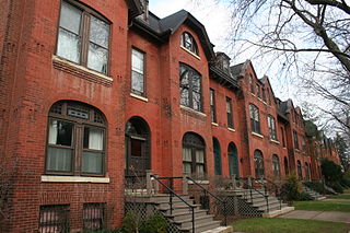
The McCormick Row House District is a group of houses located in the Lincoln Park community area in Chicago, Illinois, USA. It sits between East and West parts of DePaul University's Lincoln Park Campus and is independent from the school. They were built between 1884 and 1889 and used by the McCormick Theological Seminary to gain rental income. They were designed in the Queen Anne Style by the A. M. F. Colton and Son architects and joined the list of Chicago Landmarks May 4, 1971. The McCormick Row House District also lies within the boundaries of the Sheffield Historic District.

Douglas Park (Chicago) park in Illinois, United States of America, United States of America

Douglas Park is a large Chicago Park District park that serves as a cultural and community center on the West Side of Chicago, Illinois. It is named after the U.S. Senator Stephen A. Douglas. Originally named South Park, its 173 acres (0.70 km2) are in the North Lawndale community area with an official address of 1401 S. Sacramento Drive.

Chicago Avenue Pumping Station United States historic place

The Chicago Avenue Pumping Station is a historic district contributing property in the Old Chicago Water Tower District landmark district. It is located on Michigan Avenue along the Magnificent Mile shopping district in the Near North Side community area of Chicago, Illinois. It is on the east side of Michigan Avenue opposite the Chicago Water Tower.

Pallisers Cottage Home No. 35 building in Illinois, United States

The Palliser's Cottage Home No. 35 is a Stick Style house at 2314 West 111th Place in the Morgan Park neighborhood of Chicago, Illinois, United States. Plans for the house appeared in the pattern book of Palliser, Palliser & Co. in 1878 and this house was built in 1882 for Rev. Johan Edgren. It was designated a Chicago Landmark on February 16, 2000.

Jobbers Canyon Historic District United States historic place

Jobbers Canyon Historic District was a large industrial and warehouse area comprising 24 buildings located in downtown Omaha, Nebraska, USA. It was roughly bound by Farnam Street on the north, South Eighth Street on the east, Jackson Street on the south, and South Tenth Street on the west. In 1989, all 24 buildings in Jobbers Canyon were demolished, representing the largest National Register historic district loss to date.

Loop Retail Historic District United States historic place

Loop Retail Historic District is a shopping district within the Chicago Loop community area in Cook County, Illinois, United States. It is bounded by Lake Street to the north, Ida B. Wells Drive to the south, State Street to the west and Wabash Avenue to the east. The district has the highest density of National Historic Landmark, National Register of Historic Places and Chicago Landmark designated buildings in Chicago. It hosts several historic buildings including former department store flagship locations Marshall Field and Company Building, and the Sullivan Center. It was added to the National Register of Historic Places on November 27, 1998. It includes 74 contributing buildings and structures, including 13 separately listed Registered Historic Places, and 22 non-contributing buildings. Other significant buildings in the district include the Joffrey Tower, Chicago Theatre, Palmer House, and Page Brothers Building. It also hosts DePaul University's College of Commerce, which includes the Kellstadt Graduate School of Business and the Robert Morris College.

Cultural Center Historic District (Detroit, Michigan) United States historic place

The Cultural Center Historic District is a historic district located in Midtown Detroit, Michigan, which includes the Art Center : the Detroit Public Library, the Detroit Institute of Arts, and the Horace H. Rackham Education Memorial Building were listed on the National Register of Historic Places in 1983. The district contains several cultural attractions.

Prairie Avenue thoroughfare in Chicago, United States

Prairie Avenue is a north–south street on the South Side of Chicago, which historically extended from 16th Street in the Near South Side community area of Chicago in Cook County, Illinois, United States, to the city's southern limits and beyond. The street has a rich history from its origins as a major trail for horseback riders and carriages. During the last three decades of the 19th century, a six-block section of the street served as the residence of many of Chicago's elite families and an additional four-block section was also known for grand homes. The upper six-block section includes part of the historic Prairie Avenue District, which was declared a Chicago Landmark and added to the National Register of Historic Places.

Sherman Park United States historic place

Sherman Park is a sixty-acre park in the New City neighborhood of South Side, Chicago.

National Museum of Puerto Rican Arts and Culture

The National Museum of Puerto Rican Arts and Culture is a museum in Chicago dedicated to interpreting the arts and culture of the Puerto Rican people and of the Puerto Ricans in Chicago. Founded in 2001, it is housed in the historic landmark Humboldt Park stables and receptory, near the Paseo Boricua. It hosts visual arts exhibitions, community education, and festivals. Its exhibitions have featured the artwork of Osvaldo Budet, Elizam Escobar, Antonio Martorell, Ramon Frade Leon, and Lizette Cruz, in addition to local Chicago or Puerto Rican artists. The Institute also sponsors music events including an annual Navi-Jazz performance, described as a "fusion of Puerto Rican and African American musical elements."

Independence Park (Chicago) United States historic place

Independence Park, officially Park #83 of the Chicago Park District, is a 7.16-acre (2.90 ha) recreational area in the Irving Park neighborhood of North Side, Chicago, Illinois.

The Womans Building (Chicago) Building at the Worlds Fair held in Chicago in 1893

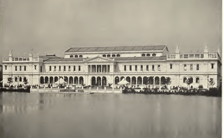
The Woman's Building was designed and built for the World's Columbian Exposition held in Chicago in 1893. It had exhibition space as well as an assembly room, a library, and a Hall of Honor. The History of the World's Fair states, "It will be a long time before such an aggregation of woman's work, as may now be seen in the Woman's Building, can be gathered from all parts of the world again."

References

  1. "National Register Information System". National Register of Historic Places . National Park Service. July 9, 2010.
  2. 1 2 3 4 "Palmer Park". Chicago Park District. Retrieved April 10, 2016.

Coordinates: 41°41′28″N87°36′57″W / 41.6910°N 87.6158°W / 41.6910; -87.6158

Geographic coordinate system Coordinate system

A geographic coordinate system is a coordinate system that enables every location on Earth to be specified by a set of numbers, letters or symbols. The coordinates are often chosen such that one of the numbers represents a vertical position and two or three of the numbers represent a horizontal position; alternatively, a geographic position may be expressed in a combined three-dimensional Cartesian vector. A common choice of coordinates is latitude, longitude and elevation. To specify a location on a plane requires a map projection.