
The Loop is Chicago's central business district and one of the city's 77 municipally recognized community areas. Located at the center of downtown Chicago on the shores of Lake Michigan, it is the second-largest business district in North America after Midtown Manhattan. The headquarters and regional offices of several global and national businesses, retail establishments, restaurants, hotels, and theaters–as well as many of Chicago's most famous attractions–are located in the Loop. The neighborhood also hosts Chicago's City Hall, the seat of Cook County, offices of other levels of government, and several foreign consulates. The intersection of State Street and Madison Street in the Loop is the origin point for the address system on Chicago's street grid.

Lakeview, also spelled Lake View, is one of the 77 community areas of Chicago, Illinois. Lakeview is located in the city's North Side. It is bordered by West Diversey Parkway on the south, West Irving Park Road on the north, North Ravenswood Avenue on the west, and the shore of Lake Michigan on the east. The Uptown community area is to Lakeview's north, Lincoln Square to its northwest, North Center to its west, and Lincoln Park to its south. The 2020 population of Lakeview was 103,050 residents, making it the second-largest Chicago community area by population.

Jackson Park is a 551.5-acre (223.2 ha) urban park on the shore of Lake Michigan on the South Side of Chicago. Straddling the Hyde Park, Woodlawn, and South Shore neighborhoods, the park was designed in 1871 by Frederick Law Olmsted and Calvert Vaux and remodeled in 1893 to serve as the site of the World's Columbian Exposition. It is one of the largest and most historically significant parks in the city, and many of the park's features are mementos of the fair—including the Garden of the Phoenix, the Statue of TheRepublic, and the Museum of Science and Industry.
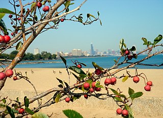
South Shore is one of 77 defined community areas of Chicago, Illinois, United States. Located on the city's South Side, the area is named for its location along the city's southern lakefront. Although South Shore has seen a greater than 40% decrease in residents since Chicago's population peaked in the 1950s, the area remains one of the most densely populated neighborhoods on the South Side. The community benefits from its location along the waterfront, its accessibility to Lake Shore Drive, and its proximity to major institutions and attractions such as the University of Chicago, the Museum of Science and Industry, and Jackson Park.

The Near South Side is a community area of Chicago, Illinois, United States, just south of the downtown central business district, the Loop. The Near South Side's boundaries are as follows: North—Roosevelt Road ; South—26th Street; West—Chicago River between Roosevelt and 18th Street, Clark Street between 18th Street and Cermak Road, Federal between Cermak Road and the Stevenson Expressway just south of 25th Street, and Clark Street again between the Stevenson and 26th Street; and East—Lake Michigan.

Douglas, on the South Side of Chicago, Illinois, is one of Chicago's 77 community areas. The neighborhood is named for Stephen A. Douglas, Illinois politician and Abraham Lincoln's political foe, whose estate included a tract of land given to the federal government. This tract later was developed for use as the Civil War Union training and prison camp, Camp Douglas, located in what is now the eastern portion of the Douglas neighborhood. Douglas gave that part of his estate at Cottage Grove and 35th to the Old University of Chicago. The Chicago 2016 Olympic bid planned for the Olympic Village to be constructed on a 37-acre (15 ha) truck parking lot, south of McCormick Place, that is mostly in the Douglas community area and partly in the Near South Side.

Fuller Park is the 37th of Chicago's 77 community areas. Located on the city's South Side, it is 5 miles (8.0 km) from the Loop. It is named for a small park also known as Fuller Park within the neighborhood, which is in turn named for Melville Weston Fuller, a Chicago attorney who was the Chief Justice of the United States between 1888 and 1910.
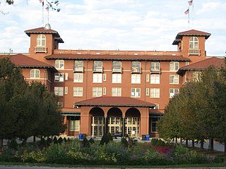
The South Shore Cultural Center, in Chicago, Illinois, is a cultural facility located at 71st Street and South Shore Drive, in the city's South Shore neighborhood. It encompasses the grounds of the former South Shore Country Club.

The Marquette Building, completed in 1895, is a Chicago landmark that was built by the George A. Fuller Company and designed by architects Holabird & Roche. The building is currently owned by the John D. and Catherine T. MacArthur Foundation. It is located in the community area known as the "Loop" in Cook County, Illinois, United States.

Carbondale station is an Amtrak intercity train station in Carbondale, Illinois, United States. The southern terminus of Amtrak's Illini and Saluki routes, it is also served by the City of New Orleans. Amtrak Thruway service between Carbondale and St. Louis, Missouri connects with the City of New Orleans. Carbondale is the southernmost Amtrak station in Illinois.
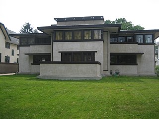
The Frank Lloyd Wright/Prairie School of Architecture Historic District is a residential neighborhood in the Cook County, Illinois village of Oak Park, United States. The Frank Lloyd Wright Historic District is both a federally designated historic district listed on the U.S. National Register of Historic Places and a local historic district within the village of Oak Park. The districts have differing boundaries and contributing properties, over 20 of which were designed by Frank Lloyd Wright, widely regarded as the greatest American architect.

Pullman National Historical Park is a historic district located in Chicago, Illinois, United States, which in the 19th century was the first model, planned industrial community in the United States. The district had its origins in the manufacturing plans and organization of the Pullman Company and became one of the most well-known company towns in the United States, as well as the scene of the violent 1894 Pullman strike. It was built for George Pullman as a place to produce the Pullman railroad-sleeping cars.

The Emil Bach House is a Prairie style house in the Rogers Park neighborhood of Chicago, Illinois, United States that was designed by architect Frank Lloyd Wright. The house was built in 1915 for an admirer of Wright's work, Emil Bach, the co-owner of the Bach Brick Company. The house is representative of Wright's late Prairie style and is an expression of his creativity from a period just before his work shifted stylistic focus. The Bach House was declared a Chicago Landmark on September 28, 1977, and was added to the U.S. National Register of Historic Places on January 23, 1979.
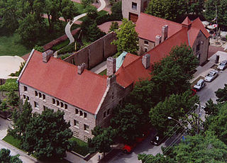
Prairie Avenue is a north–south street on the South Side of Chicago, which historically extended from 16th Street in the Near South Side to the city's southern limits and beyond. The street has a rich history from its origins as a major trail for horseback riders and carriages. During the last three decades of the 19th century, a six-block section of the street served as the residence of many of Chicago's elite families and an additional four-block section was also known for grand homes. The upper six-block section includes part of the historic Prairie Avenue District, which was declared a Chicago Landmark and added to the National Register of Historic Places.
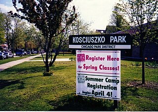
Kosciuszko Park is a park located at 2732 N. Avers Ave. Situated along the northern boundary of Chicago's Logan Square community area at Diversey, it is heavily frequented by residents of Avondale and is considered to be part of Jackowo.

Danville is a city in and the county seat of Vermilion County, Illinois, United States. As of the 2020 census, its population was 29,204. It is the principal city of the Danville micropolitan area.

Hamilton Park is a public park at 513 W. 72nd Street in the Englewood neighborhood of Chicago, Illinois. The park opened in 1904 as part of a plan led by the South Park Commission to add small neighborhood parks on Chicago's South Side. It was the first public park in Englewood. Landscape designers the Olmsted Brothers and architecture firm D. H. Burnham & Company collaborated on the park's design. The park opened with a fieldhouse, baseball field, wading pool, and walkways; within the decade, the designers added gymnasiums, a playground, and tennis courts. The fieldhouse has a Beaux-Arts design, and its inside features several murals of prominent figures in American history. The park was heavily used after it opened, and the fieldhouse in particular was booked so consistently that it was expanded in the 1920s.
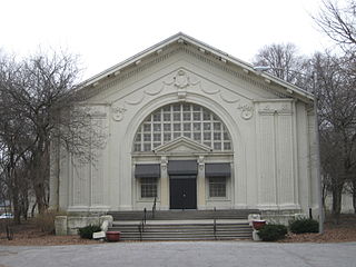
Trumbull Park is a public park at 2400 E. 105th Street in the South Deering neighborhood of Chicago, Illinois. The South Park Commission opened the park in 1907 as part of its efforts to bring parks to dense immigrant neighborhoods with little green space. The park's fieldhouse and other facilities were not completed until the 1910s; around this time, the park was officially named for Lyman Trumbull, a United States senator from Illinois who co-wrote the Thirteenth Amendment. While the park and its facilities were designed in-house by the South Park Commission, they were inspired by the designs of landscape architects the Olmsted Brothers and architecture firm D. H. Burnham and Company used in many of the South Park Commission's other parks. The fieldhouse in particular has a Beaux-Arts design which calls back to Burnham's work for the 1893 Columbian Exposition.

Davis Square is a public park located between 44th and 45th Streets and Marshfield and Hermitage Avenues in the New City community area of Chicago, Illinois. The park opened in 1905 as one of the initial parks in the South Park Commission's plan to build parks in the dense, poor neighborhoods of Chicago's South Side. It was named for Nathan Smith Davis, a Chicago physician and one of the founders of the American Medical Association. As they did for most of the South Park Commission's parks, the Olmsted Brothers designed Davis Square's landscape, while D. H. Burnham and Company designed its facilities. The park initially included a Beaux-Arts styled fieldhouse, a swimming pool and pool house, baseball fields, and walking paths.
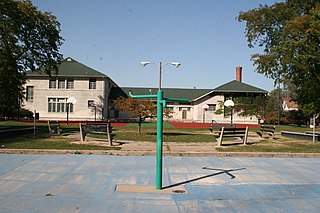
Cornell Square is a public park at 1809 W. 50th Street in the New City community area of Chicago, Illinois. Opened in 1905, the park was one of many planned by the South Park Commission to provide parks in dense, poor South Side neighborhoods. The park was named for Paul Cornell, one of the Commission's board members. As with the South Park Commission's other early parks, landscape architects the Olmsted Brothers designed the park's layout while D. H. Burnham and Company designed its facilities. The park originally included a fieldhouse with gymnasium facilities, a swimming pool, athletic fields, and walking paths. The fieldhouse has a Beaux-Arts design and includes a painting of Ezra Cornell, the founder of Cornell University and Paul Cornell's cousin.


