Rotan, Texas | |
---|---|
Coordinates: 32°51′15″N100°27′56″W / 32.85417°N 100.46556°W | |
Country | United States |
State | Texas |
County | Fisher |
Area | |
• Total | 2.02 sq mi (5.24 km2) |
• Land | 2.02 sq mi (5.24 km2) |
• Water | 0.00 sq mi (0.00 km2) |
Elevation | 1,962 ft (598 m) |
Population (2020) | |
• Total | 1,332 |
• Density | 660/sq mi (250/km2) |
Time zone | UTC-6 (Central (CST)) |
• Summer (DST) | UTC-5 (CDT) |
ZIP code | 79546 |
Area code | 325 |
FIPS code | 48-63464 [3] |
GNIS feature ID | 2411004 [2] |
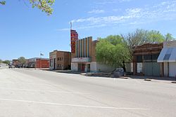
Rotan is a city in Fisher County, Texas, United States. The population was 1,332 at the 2020 census, [4] down from 1,508 at the 2010 census. [5]
Texas State Highway 70 passes through the city, leading north 34 miles (55 km) to Jayton and south 9 miles (14 km) to Roby, the Fisher County seat, and 30 miles (48 km) to Sweetwater and Interstate 20. Texas State Highway 92 leads east from Rotan 20 miles (32 km) to Hamlin.
According to the United States Census Bureau, Rotan has a total area of 2.0 mi2 (5.2 km2), all land. [5]
Rotan's climate type occurs primarily on the periphery of the true deserts in low-latitude semiarid steppe regions. The Köppen climate classification subtype for this climate is BSh (tropical and subtropical steppe climate). [6]
Climate data for Rotan, Texas (1991–2020 normals, extremes 1962–2020) | |||||||||||||
---|---|---|---|---|---|---|---|---|---|---|---|---|---|
Month | Jan | Feb | Mar | Apr | May | Jun | Jul | Aug | Sep | Oct | Nov | Dec | Year |
Record high °F (°C) | 85 (29) | 92 (33) | 100 (38) | 106 (41) | 110 (43) | 116 (47) | 112 (44) | 112 (44) | 108 (42) | 101 (38) | 92 (33) | 84 (29) | 116 (47) |
Mean daily maximum °F (°C) | 56.4 (13.6) | 61.0 (16.1) | 69.2 (20.7) | 78.5 (25.8) | 85.8 (29.9) | 92.5 (33.6) | 95.7 (35.4) | 95.0 (35.0) | 87.1 (30.6) | 77.9 (25.5) | 66.3 (19.1) | 57.5 (14.2) | 76.9 (24.9) |
Daily mean °F (°C) | 44.9 (7.2) | 49.1 (9.5) | 56.7 (13.7) | 65.8 (18.8) | 74.4 (23.6) | 82.0 (27.8) | 85.2 (29.6) | 84.2 (29.0) | 76.6 (24.8) | 66.4 (19.1) | 54.8 (12.7) | 46.5 (8.1) | 65.5 (18.6) |
Mean daily minimum °F (°C) | 33.5 (0.8) | 37.1 (2.8) | 44.2 (6.8) | 53.1 (11.7) | 63.1 (17.3) | 71.5 (21.9) | 74.6 (23.7) | 73.4 (23.0) | 66.0 (18.9) | 55.0 (12.8) | 43.4 (6.3) | 35.5 (1.9) | 54.2 (12.3) |
Record low °F (°C) | 3 (−16) | −5 (−21) | 7 (−14) | 24 (−4) | 35 (2) | 46 (8) | 57 (14) | 54 (12) | 35 (2) | 20 (−7) | 15 (−9) | −5 (−21) | −5 (−21) |
Average precipitation inches (mm) | 0.95 (24) | 1.33 (34) | 1.68 (43) | 1.77 (45) | 3.15 (80) | 2.94 (75) | 1.96 (50) | 2.18 (55) | 2.72 (69) | 2.27 (58) | 1.53 (39) | 1.06 (27) | 23.54 (598) |
Average snowfall inches (cm) | 0.4 (1.0) | 1.2 (3.0) | 0.2 (0.51) | 0.4 (1.0) | 0.0 (0.0) | 0.0 (0.0) | 0.0 (0.0) | 0.0 (0.0) | 0.0 (0.0) | 0.0 (0.0) | 0.5 (1.3) | 0.8 (2.0) | 3.5 (8.9) |
Average precipitation days (≥ 0.01 in) | 2.8 | 3.2 | 3.5 | 3.2 | 5.8 | 5.0 | 3.6 | 3.7 | 4.1 | 4.3 | 2.6 | 2.8 | 44.6 |
Average snowy days (≥ 0.1 in) | 0.3 | 0.5 | 0.1 | 0.2 | 0.0 | 0.0 | 0.0 | 0.0 | 0.0 | 0.0 | 0.3 | 0.4 | 1.8 |
Source: NOAA [7] [8] |
Census | Pop. | Note | %± |
---|---|---|---|
1910 | 1,126 | — | |
1920 | 1,000 | −11.2% | |
1930 | 1,632 | 63.2% | |
1940 | 2,029 | 24.3% | |
1950 | 3,163 | 55.9% | |
1960 | 2,788 | −11.9% | |
1970 | 2,404 | −13.8% | |
1980 | 2,284 | −5.0% | |
1990 | 1,913 | −16.2% | |
2000 | 1,611 | −15.8% | |
2010 | 1,508 | −6.4% | |
2020 | 1,332 | −11.7% | |
U.S. Decennial Census [9] |
Race | Number | Percentage |
---|---|---|
White (NH) | 667 | 50.08% |
Black or African American (NH) | 73 | 5.48% |
Native American or Alaska Native (NH) | 8 | 0.6% |
Asian (NH) | 9 | 0.68% |
Pacific Islander (NH) | 1 | 0.08% |
Some Other Race (NH) | 3 | 0.23% |
Mixed/Multi-Racial (NH) | 26 | 1.95% |
Hispanic or Latino | 545 | 40.92% |
Total | 1,332 |
As of the 2020 United States census, there were 1,332 people, 594 households, and 364 families residing in the city.
As of the census [3] of 2000, 1,611 people, 665 households, and 442 families resided in the city. The population density was 791.3 inhabitants per square mile (305.5/km2). The 841 housing units averaged 413.1 per square mile (159.2/km2). The racial makeup of the city was 72.44% White, 5.59% African American, 0.25% Native American, 0.19% Asian, 19.49% from other races, and 2.05% from two or more races. Hispanics or Latinos of any race were 32.90% of the population.
Of the 665 households, 28.0% had children under the age of 18 living with them, 51.6% were married couples living together, 11.9% had a female householder with no husband present, and 33.5% were not families; 32.3% of all households were made up of individuals, and 21.4% had someone living alone who was 65 years of age or older. The average household size was 2.35 and the average family size was 2.95.
In the city, the population was distributed as 24.6% under the age of 18, 8.0% from 18 to 24, 22.2% from 25 to 44, 21.7% from 45 to 64, and 23.5% who were 65 years of age or older. The median age was 41 years. For every 100 females, there were 87.3 males. For every 100 females age 18 and over, there were 82.2 males.
The median income for a household in the city was $21,638, and for a family was $29,038. Males had a median income of $25,688 versus $17,045 for females. The per capita income for the city was $13,097. About 16.6% of families and 22.6% of the population were below the poverty line, including 39.0% of those under age 18 and 11.9% of those age 65 or over.
The city is served by the Rotan Independent School District.
Jourdanton is a city in and the county seat of Atascosa County, Texas, United States. The population is 4,094. It is part of the San Antonio metropolitan statistical area.
Meridian is a city in and the county seat of Bosque County in Texas, United States. It is forty-seven miles northwest of Waco. The population was 1,396 at the 2020 census.
Caldwell is a city in and the county seat of Burleson County, Texas, United States. The population was 3,993 at the 2020 census. It is part of the Bryan-College Station metropolitan area.
Rusk is a city in and the county seat of Cherokee County, Texas, United States. At the 2020 United States census, it had a population of 5,285.
Paducah is a town in Cottle County, Texas, United States. The population was 1,063 at the 2020 census, down from 1,186 in 2010. It is the county seat of Cottle County. It is just south of the Texas Panhandle and east of the Llano Estacado.
Dickens is a city in and the county seat of Dickens County, Texas, United States. The population was 219 at the 2020 census, down from 286 at the 2010 census.
Rosebud is a city in Falls County, Texas, United States. Its population was 1,296 at the 2020 census.
Fairfield is a city and county seat of Freestone County, Texas, United States. The population was 2,850 at the 2020 census, down from 3,094 at the 2000 census. It was founded in 1851.
Rule is a town in Haskell County, Texas, United States. The population was 561 at the 2020 census, down from 636 at the 2010 census.
Malakoff is a city in Henderson County, Texas, United States. The population was 2,179 at the 2020 census. The city is named after a Russian fort of Malakoff, which played a pivotal role during the siege of Sevastopol during the Crimean War.
Trinidad is a city in Henderson County, Texas, United States, near the Trinity River from which the town's name was derived. The population was 860 at the 2020 census, down from 886 at the 2010 census.
Kenedy is a city in Karnes County, Texas, United States, named for Mifflin Kenedy, who bought 400,000 acres (1,600 km2) and wanted to develop a new town that would carry his name. The population was 3,473 at the 2020 census, up from 3,296 at the 2010 census.
Tahoka is a city in and the county seat of Lynn County, Texas, United States. The population was 2,375 at the 2020 census.
Natalia is a city in Medina County, Texas, United States. The population was 1,202 at the 2020 census. It was founded in 1912 and was named after Natalie Pearson Nicholson, daughter of Frederick Stark Pearson, engineer, designer and builder of the Medina Dam.
San Saba is a city located in, and the county seat of, San Saba County, Texas, United States. It was settled in 1854 and named for its location on the San Saba River and for Sabbas the Sanctified. Its population was 3,099 at the 2010 census.
Trent is a town in Taylor County, Texas, United States, that was established in 1881. The population was 295 at the 2020 census. It is part of the Abilene, Texas Metropolitan Statistical Area. Trent, Texas was named in honor of West Texas pioneer and cattleman, Isaac Riley Trent.
Sabinal is a city in Uvalde County, Texas, United States. The population was 1,364 at the 2020 census, down from 1,695 in 2010. It is part of the Uvalde, Texas Micropolitan Statistical Area.
Uhland is a city in Caldwell and Hays counties in the U.S. state of Texas. The population was 1,588 at the 2020 census, up from 1,014 at the 2010 census. Uhland is named after the German poet Ludwig Uhland. Like its neighbor to the north, the city of Niederwald, Uhland was also settled by German emigrants in the 1800s in a region of central Texas known as the Texas-German belt.
Ackerly is a city in Dawson and Martin Counties in the U.S. state of Texas. As of the 2020 Census, the population was 264. The Martin county portion of Ackerly is part of the Midland-Odessa metropolitan area.
Hamlin is a city in Jones and Fisher Counties in the U.S. state of Texas. The population was 1,831 at the 2020 census. The Jones County portion of Hamlin is part of the Abilene, Texas metropolitan area.