
Las Animas is the Statutory City that is the county seat and the only incorporated municipality in Bent County, Colorado, United States. The city population was 2,410 at the 2010 United States Census. Las Animas is located on the Arkansas River, just west of its confluence with the Purgatoire River, in southeast Colorado east of Pueblo, near the historic Bent's Fort.
Fort Larned National Historic Site preserves Fort Larned which operated from 1859 to 1878. It is approximately 5.5 miles (8.9 km) west of Larned, Kansas, United States.

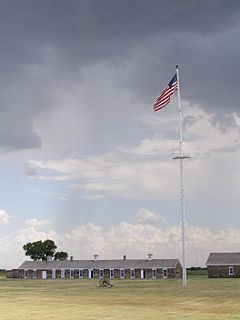
Fort Union National Monument is a unit of the National Park Service of the United States, and is located north of Watrous in Mora County, New Mexico. The national monument was founded on June 28, 1954.

Ratón Pass is a 7,834 ft (2,388 m) elevation mountain pass on the Colorado-New Mexico border in the western United States. Ratón is Spanish for "mouse". It is located on the eastern side of the Sangre de Cristo Mountains between Trinidad, Colorado and Raton, New Mexico, approximately 100 miles (160 km) northeast of Santa Fe. The pass crosses the line of volcanic mesas that extends east from the Sangre de Cristo Mountains along the state line, and furnishes the most direct land route between the valley of the Arkansas River to the north and the upper valley of the Canadian River, leading to Santa Fe, to the south. The pass now carries Interstate 25 and railroad tracks.

The Cherokee Trail was a historic overland trail through the present-day U.S. states of Oklahoma, Kansas, Colorado, and Wyoming that was used from the late 1840s up through the early 1890s. The route was established in 1849 by a wagon train headed to the gold fields in California. Among the members of the expedition were a group of Cherokee. When the train formed in Indian Territory, Lewis Evans of Evansville, Arkansas, was elected Captain. Thus, this expedition is sometimes written as the Evans/Cherokee Train.

Bent's Old Fort is an 1833 fort located in Otero County in southeastern Colorado, United States. A company owned by Charles Bent and William Bent and Ceran St. Vrain built the fort to trade with Southern Cheyenne and Arapaho Plains Indians and trappers for buffalo robes. For much of its 16-year history, the fort was the only major white American permanent settlement on the Santa Fe Trail between Missouri and the Mexican settlements. It was destroyed under mysterious circumstances in 1849.

Pecos National Historical Park is a United States National Historical Park in San Miguel and Santa Fe Counties, New Mexico. The park, operated by the National Park Service, encompasses thousands of acres of landscape infused with historical elements from prehistoric archaeological ruins to 19th-century ranches, to a battlefield of the American Civil War. Its largest single feature is Pecos Pueblo, a Native American community abandoned in historic times. First a state monument in 1935, it was made Pecos National Monument in 1965, and greatly enlarged and renamed in 1990. Two sites within the park, the pueblo and the Glorieta Pass Battlefield, are National Historic Landmarks.

This is a list of the National Register of Historic Places listings in St. Louis County, Missouri.

The Santa Fe Trail Remains, also known as Santa Fe Trail Ruts, are a two-mile (3 km) section of the former 1,200-mile (1,900 km) long Santa Fe Trail, described as the "longest continuous stretch of clearly defined Santa Fe Trail rut remains in Kansas." Now owned by a preservation organization, the site is visible from a pull-off area on United States Route 50 near Dodge City, Kansas. The site was declared a National Historic Landmark in 1963.

The Rabbit Ears are a pair of mountain peaks in northeastern New Mexico, United States, north of the city of Clayton. The two peaks were a distinctive landmark along the Cimarron Cutoff of the Santa Fe Trail, and major route for westbound settlers in the 19th century. The formation was designated a National Historic Landmark in 1963.

Boggsville is a former settlement in Bent County, Colorado, USA near the Purgatoire River about 3 miles (4.8 km) above the Purgatoire's confluence with the Arkansas River. It was established in 1866. The surviving structures are among the earliest examples of Territorial architecture in Colorado. Boggsville was the last home of frontiersman Kit Carson before his death in 1868 at Fort Lyon. The U.S. Post Office at Las Animas now serves Boggsville postal addresses.

The following outline is provided as an overview of and topical guide to the U.S. state of Colorado:

The Governor Bent House is the historic home of Governor Charles Bent who served as the first United States territorial governor of New Mexico.
The Enchanted Circle Scenic Byway is a New Mexico Scenic Byway and National Forest Scenic Byway located in Northern New Mexico. It begins and ends in Taos, New Mexico.
Fort Juelson, designated 21OT198 in the state archaeological inventory, is a historic site located east of Underwood, Minnesota, United States. An earthen fort was built at this hilltop in July 1876 after rumors of Indian attacks in Foxhome, French, and Fergus Falls following the Battle of Little Bighorn in Montana. Many settlers left the area. Charles A. Dollner, a local merchant, suggested the rest of the people band together and build the fortification under leadership of two American Civil War veterans, Hans Juelson and Berge O. Lee. The scare proved to be a hoax, and the fort was never used for defensive purposes. Remnants of the sod barricade are still on the site.
The Orwell Site, designated 21OT7 in the state archaeological inventory, is a historic site located near Fergus Falls, Minnesota, United States. It consists of twelve Middle or Late Woodland period burial mounds, four of which are enclosed by an earthwork. They were built from about A.D. 350-600. They share similarities with the mounds found at Fort Juelson, also in Otter Tail County, with their central burial chamber. The site was listed on the National Register of Historic Places in 1974.


