Green Springs National Historic Landmark District is a national historic district in Louisa County, Virginia noted for its concentration of fine rural manor houses and related buildings in an intact agricultural landscape. The district comprises 14,000 acres (5,700 ha) of fertile land, contrasting with the more typical poor soil and scrub pinelands surrounding it.

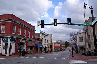
Prices Fork is a small traditionally agricultural census-designated place (CDP), in Montgomery County, Virginia, United States. The population as of the 2010 Census was 1,066. It is located about three miles west of Blacksburg and the campus of Virginia Polytechnic Institute and State University.
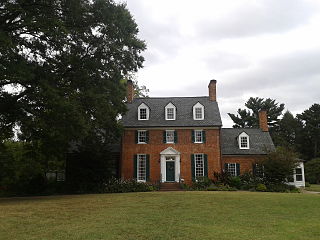
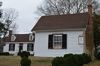
Green Spring Gardens is a public park, including a historic 18th-century plantation house "Green Spring", which is the heart of a national historic district listed on the National Register of Historic Places in 2003. The Fairfax County Park Authority operates Green Spring with the assistance of various nonprofit organizations concerned with history and gardening. Open daily without charge, the street address is 4603 Green Spring Road, Alexandria, Virginia.

Oxon Cove Park and Oxon Cove Farm is a national historic district that includes a living farm museum operated by the National Park Service, and located at Oxon Hill, Prince George's County, Maryland. It is part of National Capital Parks-East. It was listed on the National Register of Historic Places in 2003.

Edgewood is a historic farm complex located at Wingina, Nelson County, Virginia. Structures located on the 65-acre (260,000 m2) property document its evolution as a plantation and farm since the late-18th century. It includes the main house ruins, a house built about 1790 and destroyed by fire in 1955; the circa 1820 Tucker Cottage; an 18th-century dovecote, dairy, and smokehouse; an 1828 icehouse; an early 19th-century corncrib; and a mid-19th-century barn or granary. Also on the property are a circa 1940's tenant house and machine shed, the Cabell family cemetery, and an original well. The structures are all located along the gravel driveway.
Bowyer–Trollinger Farm is a historic home and farm located at Childress, Montgomery County, Virginia. The farmhouse was built in four sections beginning in about 1825 and ending in about 1910. It started as a three-bay, two-story, apparently rectangular, single-pen log dwelling. Also on the property are the contributing farm office, mid-19th-century washhouse, spring house, barn, and corn crib, and an early 20th-century apple house/carbide gas lighting outbuilding.

Cromer House, also known as Hogan Farm, is a historic home located near Childress, Montgomery County, Virginia. The farmhouse was built about 1860, and is a two-story, three-bay, rectangular single pen log structure. It features a massive brick chimney constructed of oversized bricks with pencilled mortar joints. It has a two-story, frame lean-to addition and a frame wing added in the 1930s. Also on the property is a contributing 19th century frame spring house.

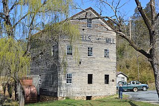
North Fork Valley Rural Historic District is a national historic district located near Blacksburg, Montgomery County, Virginia. The district encompasses 125 contributing buildings, 5 contributing sites, and 18 contributing structures. It consists of a significant rural landscape and an important collection of domestic and agricultural buildings, reflecting important agricultural practices in the region from 1745-1940. It includes domestic and agricultural buildings, a historic archaeological site, as well as an early-20th century school, two late-19th century churches, and five mid- to late-19th century industrial resources including three standing mills, a tanyard site, and a brick kiln site.

Rockbridge Alum Springs Historic District, also known as Jordan Alum Springs, and now known as Rockbridge Alum Springs - A Young Life Camp, is a historic 19th-century resort complex and national historic district near California, Rockbridge County, Virginia, United States. The district encompasses 16 contributing buildings, 10 contributing sites, and 4 contributing structures dating primarily to the 1850s, and associated with the operations of the Rockbridge Alum Springs, a popular 19th- and early-20th century mountain resort. The buildings are the barroom, store/post office, Montgomery Hall, the Gothic Building, the Alum Springs Pavilion, two cottages of Baltimore Row, the Ladies Hotel, four cottages of Kentucky Row, Jordan's House, a servant's quarters, a slave quarters, and a storehouse. The remaining structures are a well and the stone spring chambers and gazebo and bandstand of the Jordan Alum Springs. The sites are primarily those of demolished cottages. It is one of the best-preserved antebellum springs resort complexes in Virginia. The resort remained in operation until 1941. It is currently owned and operated by Young Life, a non-denominational Christian youth organization, and has been operated as a year-round campground since 1992.

Totomoi is an historic plantation in Hanover County, Virginia. The 544-acre (220 ha) property is located at 8055 Rural Point Road, near Studley. The property was, according to long-held family tradition, believed to belong to the family as early as the 17th century, but the discovery in the 21st century of family records place its purchase to 1800. The main plantation house is a brick two story building constructed in 1800 by Thomas Tinsley, one of six generations of that name. The main block is three bays wide, with a broad hall across the front and two rooms behind. Additions in 1820 and 1840 added single story ells to the east side of the house. The property includes a cluster of early 20th century farm outbuildings, and probably contains archaeological remnants of its 19th-century structures. The property, was, as of 2012, still owned by Tinsley's descendants.

The Madison Farm Historic and Archeological District is a complex of historic and prehistoric Native American and colonial sites in rural Montgomery County, Virginia. It is located in and near the flood plains of the South Fork of the Roanoke River, and covers 115 acres (47 ha). Its historic artifacts include a surviving hall-parlor log house, probably built late in the 18th century by William Madison, which is one of the few of its type to survive in the county. The building was substantially modified in the 19th century, refinishing the interior and adding a two-story porch. The farm site includes a number of historic outbuildings, and is a good prospect for archaeological investigation into period farming practices.

Amblers, also known as the Coke-Watts House, is a historic farmstead at 2205 Jamestown Road in James City County, Virginia, just north of the Jamestown peninsula. Its main house is a handsome 2-1/2 story brick structure, built in 1852 in the country style promoted by Andrew Jackson Downing, and expanded with a sympathetically styled Colonial Revival addition in the 1950s. The property includes two surviving 19th-century brick farm outbuildings, and landscaping from the 1950s that is also considered historically significant.

The Johnson County Poor Farm and Asylum Historic District is a nationally recognized historic district located in Iowa City, Iowa, United States. It was listed on the National Register of Historic Places in 2014. At the time of its nomination it consisted of 11 resources, which included three contributing buildings, two contributing sites, four contributing structures and two non-contributing buildings. It also includes the First Johnson County Asylum, which was individually listed on the National Register. The remaining buildings and structures are agricultural in nature, and were built from the late 19th-century to the early 20th-century.
The Brightwells Mill Complex historic 19th-century mill complex at 586 Brightwells Mill Road in Madison Heights, Amherst County, Virginia. It includes a reconstructed 1826 wood-frame mill, dam, miller's house, a number of outbuildings, and a small cemetery. The dam and mill both date to 1942, when a flash flood destroyed 19th-century structures. The mill was rebuilt using materials salvaged from the 1826 mill, while the dam was rebuilt in concrete. The mill was used to process the grain of local farmers until 1965.

Fuqua Farm is a historic farm property at 8700 Bethia Road in rural Chesterfield County, Virginia. The property, now about 23 acres (9.3 ha), was farmed by members of the Fuqua family from the 18th to the 21st century, and includes a vernacular 18th-century farmhouse. The farmhouse now includes elements of two structures that were joined together about 1905; in addition to the farmhouse there are also early 20th-century outbuildings, including a chicken house, garage, and shed.
Cedar Grove is a historic farm property at 1083 Blanes Mill Road in rural southern Halifax County, Virginia, north of Alton. The farm's main house is a two-story frame structure, estimated to have been built about 1775 but also altered several times in the 19th century. Its interior has a combination of Federal and Greek Revival features, and the domestic outbuildings of the property include an office with Greek and Gothic Revival features, and a small family cemetery. The house is believed to be one of the oldest surviving buildings in the county.

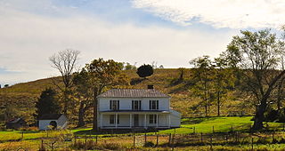
Maple Grove Farm is a historic farm property on Boners Run Road in Shawsville, Virginia. The farm complex includes an early 20th-century Colonial Revival farmhouse and a number of outbuildings, including a small log house that dates to the early period of the property's agricultural use. The property also includes a small mill complex. The land was part of a large tract given to Ephraim Vause in 1748, and developed later in the 18th century by the Madison family. The property was used for dairy and cattle production for most of the 20th century.

The Scott-Hutton Farm is a historic farm property at 1892 Turnpike Road in rural Rockbridge County, Virginia, west of Lexington. The farm property includes an early 19th-century farmhouse, to which an older log structure is appended, an early 19th-century springhouse, and several late 19th and 20th-century outbuildings. The house features fine Greek Revival styling, part of an 1843 enlargement. The early settlers were William and Ann Scott, who came to the area in 1802, and the Greek Revival alterations were made by James Hutton after he purchased the property.

The Hardin County Home Historic District, also known as Hardin County Poor Farm, Hardin County Farm, and the Hardin County Care Facility, is a nationally recognized historic district located northwest of Eldora, Iowa, United States. It was listed on the National Register of Historic Places in 2010. At the time of its nomination the district consisted of six resources, including three contributing buildings, one contributing site, and two non-contributing buildings. Beginning in the mid-19th century county homes were established across the state to take care of less fortunate residents. That care then extended to the end of the 20th century. The Hardin County Home operated at this location from 1877 to 1996. The historic district encompasses the buildings, farm fields, and cemetery associated with the home. The first burial in the cemetery, located on the southwest corner of the property, was in 1877. The graves are marked with simple stone markers. The last burial was in 2008. Farm fields surround the buildings and extend to the north.