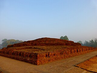
Maya is a town in the Ayodhya district of the Indian state of Uttar Pradesh, India. Maya is 24 km away from district headquarters Ayodhya city.

Sultanpur is a city situated on the banks of holy river Gomti in the Indian state of Uttar Pradesh. It is the administrative headquarters of Sultanpur district and is a part of Ayodhya division in Uttar Pradesh, India. It is situated 135 kilometers east of state capital Lucknow.

Ayodhya district is an administrative district of the Indian state of Uttar Pradesh. The city of Ayodhya is its administrative headquarters. The district occupies an area of 2,522 square kilometres (974 sq mi), and had a population of 2,470,996 in the 2011 census. Ayodhya district shares its borders with 6 districts of Uttar Pradesh. It is bordered by Gonda and Basti districts on the northern side, Amethi and Sultanpur districts on the south, and Ambedkar Nagar and Barabanki districts share the border on the east and west.
Bhadarsa is a town and nagar panchayat in Ayodhya district in state of Uttar Pradesh, India. Bhadarsa is 22 km south of district headquarters Ayodhya city.
Bikapur is a town, tehsil and nagar panchayat of Ayodhya district of Uttar Pradesh state in India. Bikapur is 25 km south of the district headquarters Ayodhya city.

Dadri is a town and a municipal board in Gautam Buddha Nagar District in the state of Uttar Pradesh, India. Noida, Dadri and Jewar are the 3 sub-divisions of GB Nagar district, each headed by a SDM.
Jewar is a town and a nagar panchayat in Gautam Buddha Nagar district in the Indian state of Uttar Pradesh. Noida, Dadri and Jewar are the 3 sub-divisions of GB Nagar district, each headed by a SDM.
Kerakat or Kirakat is a town and nagar panchayat in Jaunpur district of the Indian state of Uttar Pradesh with a population of approximately 13,500. It is situated near the Gomati River, which helps the land around the town stay very fertile. Kerakat or Kirakat forms a part of Varanasi Division. It is located 30 km east of the city of Jaunpur and 279 km from Lucknow, the capital of Uttar Pradesh.
Mariahu (Mariyahu) is a town and a nagar panchayat in Jaunpur district in the Indian state of Uttar Pradesh. Its name Mariahu was given by Nanwag (Nandwak) king Naun Rao in 16th century on the name of Mandav Deo, the patreon deity of the Nanwag clan. The samadhi of Mandav dev is situated near to Chutka Devi temple which is in the east of tehsil. Mostly tehsil was ruled by Nanwag Rajputs who were the local rulers during 16th and 17th century. Baghi Sangram Singh a leader of the Nanwags revolted against the British East India company during the revolt of 1857 and defeated them on several occasions. It is one of the six tehsils of Jaunpur district, with the others being Jaunpur city, Shahganj, Machalishahar, Badlapur and Keraket.

Musafirkhana is a town and tehsil in Amethi district in Indian state of Uttar Pradesh. The word "Musafirkhana" means "Sarai," or "Dharamshala". Musafirkhana is located 32 km northwest of Amethi, 20 km from Jagdishpur. Gauriganj and Amethi are accessible from Musafirkhana via roadways; the nearest railway station is the Musafirkhana railway station on the Lucknow–Varanasi rail route via Sultanpur, and the nearest airport is the Amausi airport. It is surrounded by more than 100 villages. The town is between 26.37° north latitude and 81.8° east longitude at a height of 102 metres (434 feet) above mean sea level.
Rudauli is a town, tehsil and a municipal board in Ayodhya district in the Indian state of Uttar Pradesh. Rudauli is 50 km west of the district headquarters Ayodhya.

Siddharthnagar district is one of the 75 districts of the Indian state of Uttar Pradesh. Siddharthnagar is the district headquarters. Siddharthnagar district is a part of Basti division. It was under the ancient Kosala kingdom and also the Shakya kingdoms.

Amethi district is the 72nd district of the state of Uttar Pradesh in northern India. This district is a part of Ayodhya division in the Awadh region of the Uttar Pradesh. It covers an area of 2329.11 km2. Gauriganj is the administrative headquarters of the district.
Goshainganj, also known as Gosainganj, is a town and nagar panchayat in the Ayodhya district of the Indian state of Uttar Pradesh. Located 32 km from the district headquarters Ayodhya, Goshainganj has one of the oldest markets of the district.
Lambhua is a town, tehsil, and a Nagar panchayat in Sultanpur district in the Indian state of Uttar Pradesh. It is located on the National Highway 731.
Rajesultanpur or Raje Sultanpur is a town and nagar panchayat in Ambedkar Nagar district in the Indian state of Uttar Pradesh.
Masodha is a town in Ayodhya district in the Indian state of Uttar Pradesh. It is a sub post office of Ayodhya and is close to the Ayodhya city. Masodha is 6 km south of the district magistrate's office. Masodha is also a block in Ayodhya district.
Tarun is a town in Bikapur tehsil, Ayodhya district in the Indian state of Uttar Pradesh, India. Tarun is 30 km south of district headquarters Ayodhya city.

Raithuwa is a village in Sohawal tehsil in Ayodhya district of the Indian state of Uttar Pradesh, India. The nearest town to Raithuwa is Bhadarsa which is 6 km away. Raituwa is 19 km south of district headquarters Ayodhya city.
Haiderganj is a town in Bikapur tehsil in Ayodhya district of Uttar Pradesh state of India. Haiderganj is 40 km south of district headquarters Ayodhya city.


