Maya is a town in the Ayodhya district of the Indian state of Uttar Pradesh, India. Maya is 24 km away from district headquarters Ayodhya city.

Ayodhya district is an administrative district of the Indian state of Uttar Pradesh. The city of Ayodhya is its administrative headquarters. The district occupies an area of 2,522 square kilometres (974 sq mi), and had a population of 2,470,996 in the 2011 census. Ayodhya district shares its borders with 6 districts of Uttar Pradesh. It is bordered by Gonda and Basti districts on the northern side, Amethi and Sultanpur districts on the south, and Ambedkar Nagar and Barabanki districts share the border on the east and west.
Bhadarsa is a town and nagar panchayat in Ayodhya district in state of Uttar Pradesh, India. Bhadarsa is 22 km south of district headquarters Ayodhya city.
Bikapur is a town, tehsil and nagar panchayat of Ayodhya district of Uttar Pradesh state in India. Bikapur is 25 km south of the district headquarters Ayodhya city.
Rudauli is a town, tehsil and a municipal board in Ayodhya district in the Indian state of Uttar Pradesh. Rudauli is 50 km west of the district headquarters Ayodhya.
Akbarpur is a city, municipal corporation, tehsil, and the administrative headquarters of Ambedkar Nagar district in the state of Uttar Pradesh, India. It is a part of Ayodhya division.
Milkipur is a town and tehsil in Ayodhya district in the Indian state of Uttar Pradesh. Milkipur is 32 km south of district headquarters Ayodhya city. District Ayodhya consists of 11 blocks and Milkipur is a block in Ayodhya, Uttar Pradesh.
Kurebhar is a town in Sultanpur district of the Uttar Pradesh state in India. Kurebhar is 20 km north of district headquarters Sultanpur city.
Khiddirpur is a village in Gram Panchayat, Bikapur Tehsil, Ayodhya district in the state of Uttar Pradesh, India. Khiddirpur is 43km south of the district headquarters Ayodhya city. The population was 1100 as of the 2001 Census of India.
Goshainganj, also known as Gosainganj, is a town and nagar panchayat in the Ayodhya district of the Indian state of Uttar Pradesh. Located 32 km from the district headquarters Ayodhya, Goshainganj has one of the oldest markets of the district.
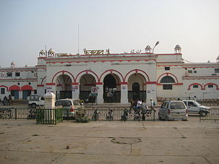
Faizabad Junction railway station, officially known as Ayodhya Cantt railway station, is a railway station in Uttar Pradesh, India. It is located on the Lucknow-Varanasi section and is a part of the Northern Railway zone. Faizabad Junction and Ayodhya Junction are the two railway junction stations in Ayodhya district.
Rajesultanpur or Raje Sultanpur is a town and nagar panchayat in Ambedkar Nagar district in the Indian state of Uttar Pradesh.
Sohawal is a town and tehsil in Ayodhya district in the Indian state of Uttar Pradesh and is sub post office of Ayodhya. Sohawal is 18 km west of district headquarters Ayodhya.
Amaniganj is a town in Milkipur tehsil, Ayodhya district in the Indian state of Uttar Pradesh. Amaniganj is situated on Milkipur-Rudauli road and is 51 km away from district headquarters Ayodhya city. Amaniganj is a block in Ayodhya, Uttar Pradesh.
Tarun is a town in Bikapur tehsil, Ayodhya district in the Indian state of Uttar Pradesh, India. Tarun is 30 km south of district headquarters Ayodhya city.
Bhelsar or Bhilser is a village in Rudauli tehsil, Ayodhya district in the Indian state of Uttar Pradesh, India. Bhelsar is situated on NH-27 Ayodhya- Barabanki road in Ayodhya, Uttar Pradesh. Rudauli is 3 km away from Bhelsar. And Bhelsar is 39 km west of district headquarters Ayodhya city.

Raithuwa is a village in Sohawal tehsil in Ayodhya district of the Indian state of Uttar Pradesh, India. The nearest town to Raithuwa is Bhadarsa which is 6 km away. Raituwa is 19 km south of district headquarters Ayodhya city.
Nandigram, also known by ancient name Bharatkund, is a village and religious place in Sohawal tehsil in Ayodhya district in the Indian state of Uttar Pradesh, India. During the exile of Lord Ram, King Bharat ruled from Nandigram instead of the kingdom's capital Ayodhya. Nandigram is 19 km (12 mi) south of district headquarters Ayodhya city.
Haiderganj is a town in Bikapur tehsil in Ayodhya district of Uttar Pradesh state of India. Haiderganj is 40 km south of district headquarters Ayodhya city.
Dhamhar is a village in Bikapur tehsil, Ayodhya district in the Uttar Pradesh state of India.


