Sokoto

Last updated

Sokoto
Front of Sokoto Sultan Palce.jpg
Sultan's Place
Nigeria location map.svg
Red pog.svg
Sokoto
Location in Nigeria
Coordinates: 13°03′44″N5°14′02″E / 13.06222°N 5.23389°E / 13.06222; 5.23389
Country Flag of Nigeria.svg Nigeria
State Sokoto State
Government
  Sultan Sa'adu Abubakar
  Governor Ahmad Aliyu Sokoto
Population
 (2006 census) [1]
  Total427,760
GDP (PPP, 2015 int. Dollar)
  Year2023
  Total$3,3 billion [2]
  Per capita$4,600
Climate BSh
Sokoto river basin, showing location of the city Sokotorivermap.png
Sokoto river basin, showing location of the city

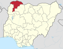
Sokoto is a major city located in extreme north-western Nigeria, near the confluence of the Sokoto River and the Rima River. As of 2006, it has a population of over 427,760. Sokoto is the modern-day capital of Sokoto State and was previously the capital of the north-western states. Modern Sokoto is known for trading sheepskins, cattle hides, leather crafts (a significant export), kola nuts and goatskins. [3]

Contents

The seat of the former Sokoto Caliphate, the city is predominantly Muslim and an important seat of Islamic learning in Nigeria. The Sultan who heads the caliphate is effectively the spiritual leader of Nigerian Muslims.

Name and etymology

The name Sokoto (which is the modern/anglicised version of the local name, Sakkwato) is of Arabic origin, representing sooq, 'market' in English. It is also known as Sakkwato, Birnin Shaihu da Bello or "Sokoto, Capital of Shaihu and Bello".

Climate

Sokoto has a hot semi-arid climate (Köppen climate classification BSh). It is located in the dry Sahel surrounded by sandy savannah and isolated hills.

With an annual average temperature of 28.3 °C (82.9 °F), Sokoto is one of the hottest cities in Nigeria, however the maximum daytime temperatures are generally under 40 °C (104.0 °F) most of the year, and the dryness makes the heat bearable. [4] The warmest months are February to April, where daytime temperatures can exceed 40 °C. The highest recorded temperature is 45 °C. The rainy season is from June to October, during which showers are a daily occurrence. The showers rarely last long and are a far cry from the regular torrential showers known in many tropical regions. From late October to February, during the 'cold season', the climate is dominated by the harmattan wind blowing Sahara dust over the land. The dust dims the sunlight, thereby reducing temperatures significantly.

The region's lifeline for growing crops is the floodplains of the Sokoto-Rima river system, which are covered with rich alluvial soil. For the rest, the crops cultivated in Sokoto includes millet, guinea corn, beans perhaps being the most abundant, followed by maize, rice, sesame, other cereals and vegetables such as: onions, tomatoes, pepper, garden egg, lettuce, and cabbage. [4] [5] Apart from millet, Sokoto is the major onion producer in Nigeria, in terms of vegetation, Sokoto falls within the savannah zone. This is an open tse-tse fly-free grassland suitable for cultivation of grain crops and animal husbandry. Rain starts late and ends early with mean annual rainfall ranging between 500 mm and 1,300 mm. There are two major seasons in Sokoto, namely wet and dry. The dry season starts from October, and lasts up to April in some parts and may extend to May or June in other parts. The wet season on the other hand begins in most parts of the state in May and lasts up to September, or October. The harmattan, a dry, cold and fairly dusty wind is experienced in the state between November and February. Heat is more severe in the state in March and April. But the weather in the state is always cold in the morning and hot in the afternoons, save in peak harmattan period.

The topography of the state is dominated by the Hausa plain of northern Nigeria. The vast irrigable land of the Sokoto-Rima River systems dissects the plain and provides the rich alluvial soil fit for a variety of crop cultivation in the state. There are also isolated hills and mountains scattered all over the state.

Climate data for Sokoto (1981–2010)
MonthJanFebMarAprMayJunJulAugSepOctNovDecYear
Mean daily maximum °C (°F)32.1
(89.8)
34.8
(94.6)
38.6
(101.5)
40.6
(105.1)
39.0
(102.2)
36.2
(97.2)
32.8
(91.0)
31.3
(88.3)
32.8
(91.0)
36.0
(96.8)
36.1
(97.0)
32.9
(91.2)
35.3
(95.5)
Daily mean °C (°F)24.5
(76.1)
27.1
(80.8)
31.2
(88.2)
33.7
(92.7)
33.1
(91.6)
30.9
(87.6)
28.2
(82.8)
27.2
(81.0)
28.0
(82.4)
29.7
(85.5)
28.3
(82.9)
25.3
(77.5)
28.9
(84.1)
Mean daily minimum °C (°F)16.9
(62.4)
19.4
(66.9)
23.8
(74.8)
26.9
(80.4)
27.3
(81.1)
25.6
(78.1)
23.6
(74.5)
23.1
(73.6)
23.2
(73.8)
23.4
(74.1)
20.5
(68.9)
17.7
(63.9)
22.6
(72.7)
Average rainfall mm (inches)0.0
(0.0)
0.1
(0.00)
1.5
(0.06)
4.8
(0.19)
46.5
(1.83)
80.0
(3.15)
186.6
(7.35)
200.5
(7.89)
109.8
(4.32)
17.2
(0.68)
0.0
(0.0)
0.0
(0.0)
647
(25.47)
Average rainy days (≥ 0.2 mm)0001471114820047
Average relative humidity (%)24192134506276838064362748
Mean monthly sunshine hours 288.3268.4275.9255.0272.8279.0229.4186.0237.0303.8300.0300.73,196.3
Mean daily sunshine hours 9.39.58.98.58.89.37.46.07.99.810.09.78.8
Source 1: World Meteorological Organization [6]
Source 2: Deutscher Wetterdienst (humidity, 1951–1965 and sun, 1952–1961) [7]

Historical development

Market at Sokoto, early 1850s Travels and discoveries in North and Central Africa. From the journal of an expedition undertaken under the auspices of H.B.M.'s government, in the years 1849-1855 (1859) (14781116835).jpg
Market at Sokoto, early 1850s
The Sokoto area, crudely shown on an 1897 map West Africa in 1897.jpg
The Sokoto area, crudely shown on an 1897 map
Sokoto Sultanate during the reign of sultan Ahmadu Rufai Sokoto Sultanate.png
Sokoto Sultanate during the reign of sultan Ahmadu Rufai

Sokoto had been used as early as October 1804 by the Shehu Usmanu Dan Fodiyo as the venue for the meeting with Galadima, Yunfa's Vizier. Subsequently, it was used by his son Muhammad Bello as a staging post for an attack on Dufua in the spring of 1806. Bovil suggested that the area/district may have been known as Sokoto as early as the seventeenth century. In historical perspective, Sokoto was founded as a ribat (military camp or frontier) in 1809, when Shehu Usmanu was at Sifawa. It later became the capital of the caliphate after Shehu's death.

In the 1820s, Sokoto was at its peak of prosperity coinciding with the peak of its 'rulers' powers at the center of the caliphate, receiving annual tribute from all the fiefs before a long period of decline. The explorer Hugh Clapperton (1827) was highly impressed by this prosperity and its effects on the city.

Clapperton noted the importance of Sokoto's closely settled surroundings: The rivers, rather than long-distance trade in the city's economy. But trading activities in Sokoto is presently inconsiderable, owing to the disturbed state of the surrounding country.

By the time the explorer Heinrich Barth arrived in 1853, Sokoto was thinly inhabited and greatly dilapidated. Barth in 1857 estimated the population at only 20,000–22,000, but the market was still supplied and attended, and a thriving suburb outside the wall was more animated than Sokoto itself.

Bovil aptly described Sokoto as a strong position, with steep escarpments from the east to the north-west and a small valley on the west and the south west protecting it against surprise cavalry attacks. The town dominates the broad lowland where the two rivers, Rima and Sokoto meet, being the junction of roads from Gobir in the north, Kebbi in the south and Burmi Zamfara in the east.

In the early 19th century, the town (Sokoto) was divided into wards. Such wards include Magajin Gari ward, Waziri ward, Sarkin Musulmi ward, Sarkin Adar ward, Magajin Rafi ward, and Sarkin Zamfara Ward. At this time the wards were small and surrounded with a wall, which included the mosques of Sultan Bello and Shehu, Sultan Palace and other buildings as well as the compound of Shehu.

In 1818, the wall was extended up to the extent that it has gates that come in and out of the Birni wall. Such gates are Kofar-Kade, Kofar-Kware, Kofar-Rini, Kofar-Dundaye, Kofar-Taramniya, Kofar-Aliyu Jedo, and Kofar-Marke.

View of the city's outskirts (1890) View of Sokoto (1890).jpg
View of the city's outskirts (1890)

The area of the present Sokoto was the home of many empires and kingdoms of the pre-colonial western Sudan. These include the Gobir and Kebbi kingdoms as well as the world-renowned caliphate whose spiritual and political capital is the headquarters of the state.

Following the conquest of the caliphate by the British in 1903, its various components were made autonomous and joined into the government of Northern Nigeria. The northern region was thus made up of mainly parts of the Sokoto caliphate and Kanem-Bornu Empire. This continued up to January 1967 when states were created to replace regional governments by General Yakubu Gowon. Sokoto became the headquarters of the north-western state created in 1967. In 1976 following the creation of Niger state out of North Western state, Sokoto state emerged with its headquarters. Yet in Sokoto, Kebbi and Zamfara states were carved out of Sokoto, in 1991 and 1996 respectively. [8]

Sokoto metropolis has thus been the capital of various governments since its establishment by Caliph Muhammad Bello in 1809. [9]

People and culture

Sokoto state has a projected population of 3.7 million [10] [11] people based on a 2006 census made up of two ethnic groups namely, Fulani and Hausa. Sokoto town, the capital of Sokoto state, has a population of approximately 2.5 million. Apart from Fulani and Hausa, there are the Zabarmawa and Tuareg minorities in the local government border areas. All these groups speak Hausa as a common language. Fulfulde is spoken by the Fulani.

Hausa people in the state are made up of Gobirawa, Zamfarawa, Kabawa, Adarawa and Arawa. The Fulani's on the other hand are of two main groups; the town Fulani (Hausa : Fulanin Gida; Fula : Fulɓe Wuro) and the Nomads. The former includes the Torankawa, the clan of Shehu Usmanu Danfodiyo, Sullubawa and Zoramawa. The Torankawa are the aristocratic class since 1804.

Culturally the state is homogeneous. The people of the state are predominantly Muslim. Their mode of dress is also of Islamic origin. Two major festivals namely, Eid-el-Fitri and Eid-el-Kabir are celebrated in the state every year. The former marks the end of the Ramadan fast, while the latter features the slaughtering of rams in commemoration of an act of the Islamic prophet Ibrahim (the Jewish patriarch Abraham).

Traditional wrestling (Kokawa) and boxing (Dambe) are the two sports enjoyed by the Hausa while the Fulani and the Sullubawa entertain themselves with Sharo and Doro[ clarification needed ] respectively. Important visitors to the state are usually treated to the grand or mini durbar, an event involving the parade of heavily decorated horses and camels mounted by men in full traditional military and cultural attire.

Pollution

The public in Sokoto is at serious risk for serious health problems as a result of the airborne dust, which can cause lung conditions and increase mortality rates, particularly from cardiovascular causes. [12] [13] [14]

Economic activities

Sokoto Market Sokoto market 2006.jpg
Sokoto Market

Over eighty percent (80%) of the inhabitants of Sokoto practice one form of agriculture or another. They produce crops like millet, guinea corn, maize, rice, potatoes, cassava, groundnuts , beans etc.for subsistence and produce wheat, cotton and vegetables for cash. Local crafts such as blacksmithing, weaving, dyeing, carving and leather works also play an important role in the economic life of the people of Sokoto; as a result, different areas like Makera, Marina, Takalmawa and Majema became important. Sokoto is also one of the fish producing areas of the country. Thus a large number of people along the river basin engage in fishing.

Sokoto is equally endowed with natural and mineral resources. Agro allied industries using cotton, groundnut, sorghum, gum, maize, rice, wheat, sugar cane, cassava, gum Arabic and tobacco as raw materials can be established in the area. Large scale farming can also be practice in the state using irrigation water from Goronyo Dam, Lugu, Kalmalo, Wammakko and Kwakwazo lakes among others.

Mineral resources such as kaolin, gypsum, limestone, laterite, red mills, phosphate both yellow and green, shade clay, sand etc., are available in commercial quantities. Mineral based industries using these raw materials could be established in the state.

The absence of the tse-tse fly on the open grassland benefits both wild and domestic animals. Sokoto ranks second in livestock production in the country's animal population of well over eight million.

The availability of these economic potentials provides good investment opportunities, particularly in agro-allied industries such as flour mills, tomatoes processing, sugar refining, textiles, glue, tanning, fish canning, etc.

Transport

Sokoto lacks a public transport system. Transport within the city (when not by foot) is mainly by mopeds which operate as one-person taxis and sometimes tricycles transport persons from one place to the other; this allows for carriage of more than one person at a time (still at a cheap price as mopeds). Buses and taxis are infrequent and are generally used only for transport between cities.

Remarkably for an area where fewer than 2% of girls finish secondary school, an all-female garage has been established in Sokoto city to train young women on vehicle maintenance. Founded by the Nana: Girls and Women Empowerment Initiative, the garage trains 25 female apprentices with the support of the local Islamic leadership. [15]

10 km south of Sokoto there is an international airport with regular connections to Abuja, Kano and Lagos.

Industry

In August 2008, an agreement was signed for the construction of a cement works in Sokoto, and the plant was opened in 2022. [16]

Urbanization

Urbanization has a very long history in Hausaland. The process started when certain strategic areas of Hausaland developed from Kauyuka to Birane. Yet one of the major consequences of the jihadist was the speeding of this phenomenon not only in Hausaland but also in all areas affected by the caliphate administration. New towns sprang up and the older birane entered into a period of unprecedented growth, some as new areas of commercial activities, others as both Emirate capitals and centers of administration and commerce.

One of the aspects of urbanization in the history of the Sokoto caliphate started with the establishment of Sokoto city (the headquarters of the caliphate). In the prejihad period, the area between the Gobir Kingdom and Kebbi was the area commonly referred to as "nomad land". But with the success of the jihad led by the Shehu usmau dan Fodiyo (1804–1808) and subsequent victory of the jihadists over the rulers of Hausaland, Sokoto city (headquarters of the caliphate) was built by Muhammad Bello. Moreover, as observed by Abdul-Razaq Shehu in his book Sakkwato Birnin Shehu), Sokoto city was designed on paper by Muhammad Bello even before it was built. Bello, son of the Sheikh, was among his father's lieutenants and war commanders. He fought the hardest and longest wars and was the architect of the caliphate Sokoto Birnin Shehu.

Sokoto city as designed by the architect Muhammad Bello consisted of all the characteristic features of any modern city including roads, bridges, market, ganuwa (fortification round centers of town) and as well as administrative and commercial centers. Among the administrative centers designed by Muhammad Bello are Kanwuri, Binanchi, Galadanci, Alkalanci, Dogarawa and so on. However, apart from the central market popularly known as Yardole, other commercial areas designed by Muhammad Bello include Makera, Madinka, Marina, Siriddawa, Takalmawa, Runji and Jirgawa. In addition, among other things no town in either pre-jihad or 19th century Hausaland could develop into an urban center without effective fortification (ganuwa). This was built with many strongpoints like Kofar Aliyu Jedo, Kofar Dundaye, Kofar Marke, Kofar Rini, Kofar Kware, and Kofar Taramniya, and this paramount development attracted many people to migrate from their locality into Sokoto city for survival.

From the above observation on how caliph Muhammad Bello designed the city of Sokoto we will see that Sokoto witnessed more immigrants with interest in blacksmithing leather works, pottery etc. For example, some of these people either engage in the business of blacksmithing or in other related business as in Makera Assada. There are people who used to travel to different parts of present Nigeria and even in neighbouring countries to buy damaged iron materials like damaged vehicles, cars, lorries, aircraft etc. iron pipes, and oil tanks in order to break them into pieces and sell them for anybody who wants to put them into use or modify them into another product.

Environmental issues

Climate change

Because Sokoto and the urban area around it is already located near a semi-arid zone experiencing desertification, the city already experiences the effects of climate change. [17] A 2018 analysis of the city's potential impacts, predicted decreasedd agricultural output, plants growth and water scarcity in the region around the city, interfering with food security and creating income security challenges. [17]

Notable people

See also

Related Research Articles

Shehu Usman ɗan Fodio was a Fulani scholar, Islamic religious teacher, revolutionary and a philosopher who founded the Sokoto Caliphate and ruled as its first caliph. After the successful revolution, the "Jama'a" gave him the title Amir al-Mu'minin. He rejected the throne and continued calling to Islam.

<span class="mw-page-title-main">Jihad of Usman dan Fodio</span> Military conflict in Nigeria and Cameroon (1804–1808)

The Jihad of Usman dan Fodio was a religio-military conflict in present-day Nigeria and Cameroon. The war began when Usman dan Fodio, a prominent Islamic scholar and teacher, was exiled from Gobir by King Yunfa, one of his former students.

<span class="mw-page-title-main">Sokoto Caliphate</span> Islamic state in West Africa (1804–1903)

The Sokoto Caliphate, also known as the Sultanate of Sokoto, was a Sunni Muslim caliphate in West Africa. It was founded by Usman dan Fodio in 1804 during the Fulani jihads after defeating the Hausa Kingdoms in the Fulani War. The boundaries of the caliphate are part of present-day Cameroon, Burkina Faso, Niger, and Nigeria. By 1837, the Sokoto state had a population of around 10-20 plus million people, becoming the most populous empire in West Africa. It was dissolved when the British, French and Germans conquered the area in 1903 and annexed it into the newly established Northern Nigeria Protectorate, Senegambia and Niger and Kamerun respectively.

Muhammadu Bello was the second Sultan of Sokoto and reigned from 1817 until 1837. He was also an active writer of history, poetry, and Islamic studies. He was the son and primary aide to Usman dan Fodio, the founder of the Sokoto Caliphate and the first Sultan. During his reign, he encouraged the spread of Islam throughout the region, increasing education for both men and women, and the establishment of Islamic courts. He died on October 25, 1837, and was succeeded by his brother Abu Bakr Atiku and then his son, Aliyu Babba.

<span class="mw-page-title-main">Sokoto State</span> State of Nigeria

SokotoState is one of the 36 states of Nigeria, located in the extreme northwest of the country. Bounded by Republic of the Niger to the north and west for 363 km, and the states of Zamfara to the east, and Kebbi to the south and west, partly across the Ka River. Its capital and largest city is the city of Sokoto. Sokoto is located near to the confluence of the Sokoto River and the Rima River. As of 2022 it has an estimated population of more than 6.3 million.

<span class="mw-page-title-main">Zamfara State</span> State of Nigeria

Zamfara is a state in northwestern Nigeria. The capital of Zamfara state is Gusau and its current governor is Dauda Lawal. Until 1996, the area was part of Sokoto State.

<span class="mw-page-title-main">Northern Region, Nigeria</span> Former autonomous division within Nigeria

Northern Nigeria was an autonomous division within Nigeria, distinctly different from the southern part of the country, with independent customs, foreign relations and security structures. In 1962, it acquired the territory of the British Northern Cameroons, which voted to become a province within Northern Nigeria.

<span class="mw-page-title-main">Gusau</span> Capital city of Zamfara State, Nigeria

The city of Gusau, located in northwestern Nigeria, is the capital of Zamfara State. It is also the name of the state's Local Government Area (LGA), which has an area of 3,364 km (2,090 mi)² and a population of 383,162 as of the 2006 census.

Gwandu, also called Gando, is a town and emirate in Kebbi State, Nigeria. The seat of government for the emirate and district of this name is in Birnin Kebbi, which is the capital of Kebbi State and was capital of the historical Kingdom of Kebbi. Founded in the sixteenth century by the Kabbawa, a Hausa people Gwandu today acts as one of the four emirates composing Kebbi State.

<span class="mw-page-title-main">Gobir</span> Hausa city-state or minor kingdom

Gobir was a city-state in what is now Nigeria. Founded by the Hausa in the 11th century, Gobir was one of the seven original kingdoms of Hausaland, and continued under Hausa rule for nearly 700 years. Its capital was the city of Alkalawa. In the early 19th century elements of the ruling dynasty fled north to what is today Niger from which a rival dynasty developed ruling as Sarkin Gobir at Tibiri. In 1975 a reunited traditional sultanate took up residence in Sabon Birni, Nigeria.

<span class="mw-page-title-main">Birnin Kebbi</span> Capital city of Kebbi State, Nigeria

Birnin Kebbi is a city located in Northwestern Nigeria It is the capital city of Kebbi State and headquarter of the Gwandu Emirate. As at 2007 the city had an estimated population of 125,594 people. Kebbi is mostly a Hausa and Fulani state, with Islam as the major religion. Formerly it was the capital of the Kebbi Emirate, which relocated to Argungu after the conquest by Gwandu in 1831. The town remained the capital of Kebbi until 1805, when it was burned in the Fulani jihad by Abdullahi dan Fodio, a brother of the jihad leader and later Emir of Gwandu. After Birnin Kebbi was incorporated into the Fulani Emirate of Gwandu, it was eclipsed in political importance by Gwandu (Gando) town, 30 miles (48 km) east, and as a caravan and riverside market centre by Jega, 20 miles (32 km) southeast, which lay at the head of navigation on the Zamfara River, a tributary of the Sokoto. Ironically, while Argungu became the traditional seat of the king of Kebbi in 1827, Birnin Kebbi served as the Gwandu emirate headquarters after Emir Haliru was inaugurated there in 1906. Birnin Kebbi became the capital of the newly created Nigerian state of Kebbi in 1991.

<span class="mw-page-title-main">Hausa Kingdoms</span> Collection of states started by the Hausa people

Hausa Kingdoms, also known as Hausa Kingdom or Hausaland, was a collection of states started by the Hausa people, situated between the Niger River and Lake Chad. Hausaland lay between the Western Sudanic kingdoms of Ancient Ghana, Mali and Songhai and the Eastern Sudanic kingdoms of Kanem-Bornu. Hausaland took shape as a political and cultural region during the first millennium CE as a result of the westward expansion of Hausa peoples. They arrived to Hausaland when the terrain was converting from woodlands to savannah. They started cultivating grains, which led to a denser peasant population. They had a common language, laws and customs. The Hausa were known for fishing, hunting, agriculture, salt-mining, and blacksmithing.

<span class="mw-page-title-main">Usmanu Danfodiyo University</span> University in Nigeria

Usmanu Danfodiyo University, Sokoto (UDUS), also known as UDUSOK, is a public research university located in the city of Sokoto, north western Part of Nigeria. It is one of the initial twelve universities founded in Nigeria by the federal government in 1975.

Mallam Abdullahi ɗan Fodio, a prominent Islamic scholar, jurist, poet and theologian, was the first Amir of Gwandu and first Grand Vizier of Sokoto. His brother, Usman dan Fodio (1754–1817) was the founder of the Sokoto Caliphate. Usman, being more of a scholar than politician, delegated the practical regency of the western part of his empire to Abdullahi and the eastern part to his son Muhammed Bello, who later became the Sultan of Sokoto after his father.

<span class="mw-page-title-main">Hausa people</span> Ethnic group in West Africa

The Hausa are a native ethnic group in West Africa. They speak the Hausa language, which is the second most spoken language after Arabic in the Afro-Asiatic language family. The Hausa are a culturally homogeneous people based primarily in the Sahelian and the sparse savanna areas of southern Niger and northern Nigeria respectively, numbering around 86 million people, with significant populations in Benin, Cameroon, Ivory Coast, Chad, Central African Republic, Togo, Ghana, as well as smaller populations in Sudan, Eritrea, Equatorial Guinea, Gabon, Senegal, Gambia. Predominantly Hausa-speaking communities are scattered throughout West Africa and on the traditional Hajj route north and east traversing the Sahara, with an especially large population in and around the town of Agadez. Other Hausa have also moved to large coastal cities in the region such as Lagos, Port Harcourt, Accra, Abidjan, Banjul and Cotonou as well as to parts of North Africa such as Libya over the course of the last 500 years. The Hausa traditionally live in small villages as well as in precolonial towns and cities where they grow crops, raise livestock including cattle as well as engage in trade, both local and long distance across Africa. They speak the Hausa language, an Afro-Asiatic language of the Chadic group. The Hausa aristocracy had historically developed an equestrian based culture. Still a status symbol of the traditional nobility in Hausa society, the horse still features in the Eid day celebrations, known as Ranar Sallah. Daura is the cultural center of the Hausa people. The town predates all the other major Hausa towns in tradition and culture.

Makera Assada is among the areas that form the town of Sokoto state of Nigeria. The area is part of Magajin Gari Ward in the southern part of Sokoto North local government area of Sokoto state, bordered Gidan Haki in the east, Digyar Agyare in the west, Mafara in the north and Helele in the south.

The Kebbi Emirate, also known as the Argungu Emirate is a traditional state based on the town of Argungu in Kebbi State, Nigeria. It is the successor to the ancient Hausa kingdom of Kebbi. The Emirate is one of four in Kebbi State, the others being the Gwandu Emirate, Yauri Emirate and Zuru Emirate.

Ahmadu Atiku also known as Ahmadu Zarruku was Sultan of Sokoto from 1859 to 1866. Prior to becoming Sultan, he was head of the Abu Bakr Atiku branch of Uthman Dan Fodio's family and held the title of Sarkin Zamfara with responsibilities for Sokoto town and south-east Sokoto. Atiku established the military settlement (ribat) at Chimmola which was across the valley from the town of Wurno and which he used as the seat of government.

<span class="mw-page-title-main">Dambazawa</span> Fulani clan mainly in Kano State, Nigeria

The Dambazawa are a Fulani clan residing mainly in Kano State, Nigeria. They were among the key promoters, planners and executors of the Fulani Jihad in Kano, which took place between 1804 and 1807 under the leadership of Shehu Usuman dan Fodiyo. The clan was said to be the top financier of the jihad because it was said to be extremely wealthy at the time of the jihad. Other Fulani Clans that participated in the Jihad included: the Jobawa, the Yolawa, the Sullubawa, the Danejawa and others, as well as a contingent of the native Hausa people led by Malam Usuman bahaushe. Together they formed a formidable force and toppled the 158 year Kutumbawa dynasty led by its last ruler Muhammad Alwali dan Yaji dan Dadi bakutumbe who ruled between 1781 and 1806.

<span class="mw-page-title-main">Hausa literature</span> Literature in the Hausa language

Hausa literature is any work written in the Hausa language. It includes poetry, prose, songwriting, music, and drama. Hausa literature includes folk literature, much of which has been transcribed, and provides a means of recording, preserving, and transmitting knowledge, especially in regard to social, psychological, spiritual, or political roles.

References

Citations
  1. Summing the 2 LGAs Sokoto North/South as per:
    Federal Republic of Nigeria Official Gazette (15 May 2007). "Legal Notice on Publication of the Details of the Breakdown of the National and State Provisional Totals 2006 Census" (PDF). Archived from the original (PDF) on 5 March 2012. Retrieved 19 May 2007.
  2. "TelluBase—Nigeria Fact Sheet (Tellusant Public Service Series)" (PDF). Tellusant. Retrieved 11 January 2024.
  3. "Sokoto | Map, Population, & Facts | Britannica". www.britannica.com. 7 July 2023. Retrieved 4 August 2023.
  4. 1 2 "A Brief History and Geography of Sokoto State" . Retrieved 7 April 2007.
  5. "Sokoto". Encyclopædia Britannica. Retrieved 7 April 2007.
  6. "World Weather Information Service – Sokoto". World Meteorological Organization. Retrieved 7 July 2016.
  7. "Klimatafel von Sokoto / Nigeria" (PDF). Baseline climate means (1961-1990) from stations all over the world (in German). Deutscher Wetterdienst. Retrieved 7 July 2016.
  8. "History of Sokoto - Official Website of Sokoto State Government". 29 December 2021. Retrieved 15 July 2023.
  9. "Brief History of Sokoto State :: Nigeria Information & Guide". www.nigeriagalleria.com. Retrieved 15 July 2023.
  10. Yusuf Akinpelu. "In Sokoto, Taraba, Jigawa, about nine in ten people are poor – NBS". www.premiumtimesng.com. Retrieved 10 June 2023.
  11. Mayaki, A.M (2017). "Retrospective study of equine cases at the Veterinary Teaching Hospital". Nigeria Vet. Journal. 38: 208–214.
  12. "Air Quality & Pollen Forecast for Sokoto". meteoblue. Retrieved 23 September 2023.
  13. "Sokoto Air Quality Index (AQI) and Nigeria Air Pollution | IQAir". www.iqair.com. 22 September 2023. Retrieved 23 September 2023.
  14. "Air Quality and Pollen in Sokoto, Nigeria | Tomorrow.io". Tomorrow.io Weather. Retrieved 23 September 2023.
  15. Jamiu, Abiodun (12 January 2022). "Driving change: the all-female garage shifting attitudes in northern Nigeria". The Guardian. Retrieved 21 June 2023.
  16. Release, Press (27 January 2022). "Buhari inaugurates BUA's new cement plant in Sokoto". Premium Times Nigeria. Retrieved 6 October 2022.
  17. 1 2 "Climate Change Manifestations and Impacts in The Sokoto Close-Settled Zone, Northwestern Nigeria" (PDF). Akademika. 88 (2): 21–34. July 2018 via Core UK.
Sources