Solomon Temple (Grand Canyon)

Last updated
Solomon Temple
Solomon Temple in Grand Canyon.jpg
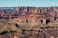
Solomon Temple centered in bullseye.
Southwest aspect, from Grandview Point.
Highest point
Elevation 5,121 ft (1,561 m) [1]
Prominence 661 ft (201 m) [1]
Parent peak Rama Shrine (6,406 ft) [1]
Isolation 1.41 mi (2.27 km) [1]
Coordinates 36°03′26″N111°54′56″W / 36.0572709°N 111.9155355°W / 36.0572709; -111.9155355 Coordinates: 36°03′26″N111°54′56″W / 36.0572709°N 111.9155355°W / 36.0572709; -111.9155355 [2]
Geography
USA Arizona relief location map.svg
Red triangle with thick white border.svg
Solomon Temple
Location in Arizona
Usa edcp relief location map.png
Red triangle with thick white border.svg
Solomon Temple
Solomon Temple (the United States)
Location Grand Canyon National Park
Coconino County, Arizona, US
Parent range Kaibab Plateau
Colorado Plateau
Topo map USGS Cape Royal
Geology
Type of rock limestone, sandstone, shale

Solomon Temple is a 5,121-foot-elevation (1,561-meter) summit located in the Grand Canyon, in Coconino County of northern Arizona, USA. [2] It is situated four miles north of Moran Point, 3.5 miles east of Newberry Butte, and 1.5 mile southeast of Rama Shrine, its nearest higher neighbor. Topographic relief is significant as it rises 2,500 feet (760 meters) above the Colorado River in less than one mile.

Contents

Solomon Temple was named after historical king Solomon by geologist François E. Matthes, following Clarence Dutton's practice of naming geographical features in the Grand Canyon after mythological deities and heroic figures. [3] [4] This feature's name was officially adopted in 1906 by the U.S. Board on Geographic Names. [2]

Solomon Temple is a butte composed of Mississippian Redwall Limestone, which overlays shale of the Cambrian Tonto Group. [5] The Solomon Temple Member of the Dox Formation is so named because of exposures 2.4 kilometers northeast of this butte. [6]

According to the Köppen climate classification system, Solomon Temple is located in a Cold semi-arid climate zone. [7]

See also

Related Research Articles

<span class="mw-page-title-main">Brahma Temple (Grand Canyon)</span> Landform in the Grand Canyon, Arizona

Brahma Temple is a 7,551-foot-elevation summit located in the Grand Canyon, in Coconino County of Arizona, US. It is situated six miles (9.7 km) north-northeast of the Yavapai Point overlook on the canyon's South Rim, and 4.5 miles south of the North Rim's Bright Angel Point. It towers 5,000 feet above Phantom Ranch in Bright Angel Canyon. Its nearest higher neighbor is Oza Butte, four miles to the north-northwest. Other neighbors include Zoroaster Temple one mile to the south, and Deva Temple, 1.5 miles to the north. Brahma Temple is named for Brahma, the Hindu creator of the universe. This name was applied by Clarence Dutton who began the tradition of naming geographical features in the Grand Canyon after mythological deities. This geographical feature's name was officially adopted in 1906 by the U.S. Board on Geographic Names.

<span class="mw-page-title-main">Vishnu Temple (Grand Canyon)</span> Landform in the Grand Canyon, Arizona

Vishnu Temple is a 7,533-foot-elevation (2,296-meter) summit located in the Grand Canyon, in Coconino County of Arizona, US.

<span class="mw-page-title-main">Wotans Throne</span> Landform in the Grand Canyon, Arizona

Wotans Throne is a 7,721-foot-elevation (2,353-meter) summit located in the Grand Canyon, in Coconino County of Arizona, US. It is situated one mile immediately southwest of the Cape Royal overlook on the canyon's North Rim, 1.7 mile west-southwest of Freya Castle, two miles west-northwest of Vishnu Temple, and five miles east of Zoroaster Temple. It rises 5,200 feet above the Colorado River.

<span class="mw-page-title-main">Tower of Set</span> Landform in the Grand Canyon, Arizona

Tower of Set is a 6,012-foot-elevation (1,832-meter) summit located in the Grand Canyon, in Coconino County of Arizona, US. This butte is situated four miles north of Hopi Point overlook on the canyon's South Rim, two miles southeast of Tower of Ra, and three miles south-southwest of Shiva Temple, where it towers 3,600 feet above the Colorado River. Tower of Set was originally named Temple of Sett in 1879 by Thomas Moran, for the Egyptian deity of war, Set, because a niche worn into its wall evoked temples in the valley of the Nile. Another source states it was named by George Wharton James, in keeping with Clarence Dutton's tradition of naming geographical features in the Grand Canyon after mythological deities. This mountain's name was officially adopted in 1906 by the U.S. Board on Geographic Names. In 1919, Harriet Williams Russell Strong proposed connecting Hopi Point and Tower of Set across the river via an aerial tramway, an idea that never came to fruition. The first ascent was made in November 1977 by Bruce Grubbs and Jim Haggart. According to the Köppen climate classification system, Tower of Set is located in a cold semi-arid climate zone.

<span class="mw-page-title-main">Angels Gate</span> Landform in the Grand Canyon, Arizona

Angels Gate is a 6,761-foot (2,061 m)-elevation summit located in the Grand Canyon, in Coconino County of Arizona, United States. It is situated seven miles (11 km) due north of the Grandview Point overlook on the canyon's South Rim, three miles (4.8 km) west of Vishnu Temple, and three point five miles (5.6 km) southeast of Zoroaster Temple. Topographic relief is significant as it rises over 4,200 feet (1,300 m) above the Colorado River in three miles. Angels Gate is the place in Paiute mythology where the gods would return to earth by descending from the shadow world above. George Wharton James applied the "Angel Gate" name to this geographical feature in his book, In & Around the Grand Canyon, in 1900. This feature's name was officially adopted in 1906 by the U.S. Board on Geographic Names. Angels Gate has four peaks composed of Coconino Sandstone. The main highest summit and three spires are known as "Snoopy and his Doghouse" for a resemblance to Snoopy, and the first ascent was made April 1972 by Chuck Graf and Dave Ganci. According to the Köppen climate classification system, Angels Gate is located in a cold semi-arid climate zone.

<span class="mw-page-title-main">Gunther Castle</span> Landform in the Grand Canyon, Arizona

Gunther Castle is a 7,199-foot-elevation (2,194-meter) summit located in the Grand Canyon, in Coconino County of northern Arizona, US. It is situated three miles northwest of Chuar Butte, between Kwagunt Valley to the north, and Chuar Valley to the south. Topographic relief is significant as it rises nearly 4,500 feet above the Colorado River in three miles.

<span class="mw-page-title-main">Confucius Temple (Grand Canyon)</span> Landform in the Grand Canyon, Arizona

Confucius Temple is a 7,081-foot-elevation (2,158-meter) summit located in the Grand Canyon, in Coconino County of northern Arizona, US. It is situated 1.5 mile southeast of Point Sublime, four miles west-northwest of Shiva Temple, and three miles northwest of Tower of Ra, where it rises over 3,200 feet above Hindu Amphitheater. Confucius Temple is named for Confucius, the Chinese philosopher. This name was applied by Clarence Dutton, who began the tradition of naming geographical features in the Grand Canyon after mythological deities. Confucius Temple is one of the Twin Buttes in the Grand Canyon, the other being Mencius Temple (7,001 ft), which is named for Mencius, considered the second-most famous sage, after only Confucius himself. This mountain's name was officially adopted in 1906 by the U.S. Board on Geographic Names. According to the Köppen climate classification system, Confucius Temple has a Cold semi-arid climate.

<span class="mw-page-title-main">Freya Castle</span> Landform in the Grand Canyon, Arizona

Freya Castle is a 7,288-foot-elevation (2,221-meter) summit located in the Grand Canyon, in Coconino County of northern Arizona, US. It is situated one mile southeast of the Cape Royal overlook on the canyon's North Rim, 1.5 mile north of Vishnu Temple, and 1.7 mile northeast of Wotans Throne. Topographic relief is significant as it rises 3,400 feet above the Unkar Valley in one mile.

<span class="mw-page-title-main">Pollux Temple</span> Landform in the Grand Canyon, Arizona

Pollux Temple is a 6,251-foot-elevation (1,905-meter) summit in the Grand Canyon, in Coconino County of northern Arizona, US. It is situated ten miles northwest of Grand Canyon Village, and less than one mile northeast of Jicarilla Point. Castor Temple is one mile northwest, and Diana Temple is one mile southeast. Topographic relief is significant as Pollux Temple rises nearly 4,000 feet above the Colorado River in less than two miles. Pollux Temple is named for Pollux, the divine son of Zeus according to Greek mythology. Clarence Dutton began the practice of naming geographical features in the Grand Canyon after mythological deities. According to the Köppen climate classification system, Pollux Temple is located in a Cold semi-arid climate zone.

<span class="mw-page-title-main">Diana Temple (Grand Canyon)</span> Landform in the Grand Canyon, Arizona

Diana Temple is a 6,683-foot-elevation (2,037-meter) summit located in the Grand Canyon, in Coconino County of northern Arizona, US. It is situated nine miles northwest of Grand Canyon Village, and immediately northeast of Mescalero Point. Pollux Temple is one mile northwest, Marsh Butte one mile east-northeast, and Vesta Temple is one mile south. Topographic relief is significant as Diana Temple rises nearly 4,300 feet above the Colorado River in less than two miles. Diana Temple is named for Diana, the goddess of the hunt and the moon according to Roman mythology. Clarence Dutton began the practice of naming geographical features in the Grand Canyon after mythological deities. The U.S. Geological Survey applied the name, and this geographical feature's name was officially adopted in 1908 by the U.S. Board on Geographic Names. In the early 1900s this mesa was sometimes called "No Mans Land". According to the Köppen climate classification system, Diana Temple is located in a Cold semi-arid climate zone.

<span class="mw-page-title-main">Newberry Butte</span> Landform in the Grand Canyon, Arizona

Newberry Butte is a 5,105-foot-elevation (1,556-meter) summit located in the Grand Canyon, in Coconino County of northern Arizona, US. It is situated 4.5 miles north of the South Rim's Grandview Point, three miles southwest of Vishnu Temple, and 2.5 miles south of Wotans Throne. Topographic relief is significant as it rises over 2,500 feet above the Colorado River and Granite Gorge in one mile. According to the Köppen climate classification system, Newberry Butte is located in a Cold semi-arid climate zone.

<span class="mw-page-title-main">Alsap Butte</span> Rock formation in the Grand Canyon, Arizona, United States

Alsap Butte is a 7,494-foot-elevation (2,284-meter) summit located in the Grand Canyon in Coconino County of northern Arizona, USA. It is situated two miles north of the Roosevelt Point on the canyon's North Rim, where it towers 3,700 feet above Nankoweap Canyon. Its nearest higher neighbor is Brady Peak, one mile to the southwest, with Hancock Butte and Mount Hayden set to the northwest, and Colter Butte two miles to southeast. Alsap Butte is named after John T. Alsap, a pioneer and politician of the Arizona Territory who served as the first mayor of Phoenix, and is known as "Father of Maricopa County". The geographical feature's name was officially adopted in 1932 by the United States Board on Geographic Names. According to the Köppen climate classification system, Alsap Butte is located in a cold semi-arid climate zone. Alsap Butte is composed of Pennsylvanian-Permian Supai Group overlaying cliff-forming Mississippian Redwall Limestone, which in turn overlays slope-forming Cambrian Tonto Group. Precipitation runoff from this feature drains northeast into the Colorado River via Nankoweap Creek.

<span class="mw-page-title-main">Butchart Butte</span> Landform in the Grand Canyon, Arizona

Butchart Butte is a 7,602-foot (2,317 m)-elevation summit located in the Grand Canyon, in Coconino County of northern Arizona, United States. It is situated on the North Rim, midway between Gunther Castle and Siegfried Pyre, and between the Chuar and Kwagunt Valleys. Topographic relief is significant as it rises 4,900 feet (1,500 m) above the Colorado River in five miles.

<span class="mw-page-title-main">Vesta Temple</span> Landform in the Grand Canyon, Arizona

Vesta Temple is a 6,299-foot-elevation (1,920-meter) summit located in the Grand Canyon, in Coconino County of northern Arizona, US. It is situated eight miles west-northwest of Grand Canyon Village, and immediately northeast of Mimbreno Point. Marsh Butte is one mile northeast, Eremita Mesa immediately southeast, and nearest higher neighbor Diana Temple is one mile north. Topographic relief is significant as Vesta Temple rises 3,900 feet above the Colorado River in 2.5 miles. Vesta Temple is named for Vesta, the goddess of the hearth, home, and family according to Roman mythology. Clarence Dutton began the practice of naming geographical features in the Grand Canyon after mythological deities. This geographical feature's name was officially adopted in 1908 by the U.S. Board on Geographic Names. According to the Köppen climate classification system, Vesta Temple is located in a Cold semi-arid climate zone.

<span class="mw-page-title-main">King Arthur Castle</span> Landform in the Grand Canyon, Arizona

King Arthur Castle is a 7,344-foot-elevation (2,238-meter) summit located in the Grand Canyon, in Coconino County of northern Arizona, US. It is situated one-half mile northwest of Guinevere Castle, one mile west of Excalibur, and two miles east-southeast of Holy Grail Temple, within the Shinumo Amphitheater. Topographic relief is significant as it rises over 5,100 feet above the Colorado River in 4.5 miles (7.2 km). According to the Köppen climate classification system, King Arthur Castle is located in a cold semi-arid climate zone, with precipitation runoff draining west to the Colorado River via Shinumo Creek.

<span class="mw-page-title-main">Lyell Butte</span> Landform in the Grand Canyon, Arizona

Lyell Butte is a 5,362-foot (1,634 m) elevation summit located in the Grand Canyon, in Coconino County of northern Arizona, United States. It is situated six miles (9.7 km) east of Grand Canyon Village, immediately east of and below Shoshone Point, and 1.5 mile southeast of Newton Butte, which is the nearest higher neighbor. Topographic relief is significant as Lyell Butte rises 2,800 feet (850 m) above the Colorado River in 1.5 mile. Access is via the Tonto Trail which traverses the base of the peak. According to the Köppen climate classification system, Lyell Butte is located in a cold semi-arid climate zone, with precipitation runoff draining northeast to the Colorado River via Grapevine and Boulder Creeks.

<span class="mw-page-title-main">Evans Butte (Grand Canyon)</span> Landform in the Grand Canyon, Arizona

Evans Butte is a 6,379-foot-elevation (1,944-meter) summit located in the Grand Canyon, in Coconino County of northern Arizona, US. It is situated at the north end of Sagittarius Ridge, three miles south-southwest of King Arthur Castle, and two miles southeast of Dox Castle. Topographic relief is significant as it rises over 4,100 feet above the Colorado River in 2.5 miles (4.0 km), and the north aspect rises 2,700 feet above Flint Creek in one mile. According to the Köppen climate classification system, Evans Butte is located in a cold semi-arid climate zone, with precipitation runoff draining west to the Colorado River via Shinumo Creek, Hotauta Canyon, and Monadnock Amphitheater. The butte is composed of Pennsylvanian-Permian Supai Group overlaying the cliff-forming Mississippian Redwall Limestone, and Cambrian Tonto Group. Evans Butte was climbed solo by Harvey Butchart on October 11, 1976, thereby making it the 76th of the 83 summits which he climbed in the Grand Canyon.

<span class="mw-page-title-main">Guinevere Castle</span> Landform in the Grand Canyon, Arizona

Guinevere Castle is a 7,281-foot-elevation (2,219 meter) summit located in the Grand Canyon, in Coconino County of northern Arizona, US. It is situated one-half mile southeast of King Arthur Castle, one mile west of Excalibur, and 2.5 miles northeast of Evans Butte, within the Shinumo Amphitheater. Topographic relief is significant as it rises 5,000 feet above the Colorado River in 4.5 miles, and 2,600 feet above Gawain Abyss in one mile. According to the Köppen climate classification system, Guinevere Castle is located in a cold semi-arid climate zone.

Elaine Castle is a 7,431-foot-elevation (2,265 meter) summit located in the Grand Canyon, in Coconino County of northern Arizona, US. It is situated three miles north-northwest of King Arthur Castle near the head of Shinumo Creek, and immediately southwest of Lancelot Point. Topographic relief is significant as it rises 2,800 feet above Merlin Abyss in one mile. According to the Köppen climate classification system, Elaine Castle is located in a cold semi-arid climate zone.

<span class="mw-page-title-main">Colter Butte</span> Landform in the Grand Canyon, Arizona

Colter Butte is a 7,254-foot-elevation (2,211-meter) summit located in the Grand Canyon in Coconino County of northern Arizona, US. It is situated four miles southeast of Point Imperial, where it towers 3,600 feet above Nankoweap Canyon. Its neighbors include Brady Peak, 2.5 miles to the west-northwest, Alsap Butte two miles to the northwest, and Swilling Butte one-half mile to the east. Colter Butte is named after James G. H. Colter (1844–1922), born in Nova Scotia, Canada, he came to the Arizona Territory in 1872 as a pioneer, farmer, cattleman, Apache and desperado fighter. He was the father of Arizona state senator Fred Colter. This geographical feature's name was officially adopted in 1932 by the United States Board on Geographic Names. According to the Köppen climate classification system, Colter Butte is located in a cold semi-arid climate zone. This butte is composed of Pennsylvanian-Permian Supai Group which overlays cliff-forming Mississippian Redwall Limestone, which in turn overlays slope-forming Cambrian Tonto Group. Precipitation runoff from this feature drains east to the Colorado River via Nankoweap Creek on the north side and Kwagunt Creek from the south slope.

References

  1. 1 2 3 4 "Solomon Temple – 5,121' AZ". Lists of John. Retrieved 2021-01-22.
  2. 1 2 3 "Solomon Temple". Geographic Names Information System . United States Geological Survey, United States Department of the Interior . Retrieved 2021-01-22.
  3. N.H. Darton, Story of the Grand Canyon of Arizona, 1917, p. 81.
  4. J. Donald Hughes, The Story of Man at Grand Canyon, 1967, Grand Canyon Natural History Association, K.C. Publications, p. 106.
  5. N.H. Darton, Story of the Grand Canyon of Arizona, 1917, p. 59.
  6. Gwendolyn W. Luttrell, Marilyn L. Hubert, Cynthia R. Murdock, Lexicon of New Formal Geolocic Names of the United States 1981-1985, 1991, U.S. Department of the Interior, Geological Survey; Washington, D.C., p. 299.
  7. Peel, M. C.; Finlayson, B. L.; McMahon, T. A. (2007). "Updated world map of the Köppen−Geiger climate classification". Hydrol. Earth Syst. Sci. 11. ISSN   1027-5606.