South Buffalo Township, Pennsylvania

Last updated

South Buffalo Township, Pennsylvania
South Buffalo Township Armstrong County Pennsylvania.jpg
Countryside in South Buffalo Township
Map of South Buffalo Township, Armstrong County, Pennsylvania Highlighted.png
Map of Armstrong County, Pennsylvania, highlighting South Buffalo Township
Map of Pennsylvania highlighting Armstrong County.svg
Map of Armstrong County, Pennsylvania
Country United States
State Pennsylvania
County Armstrong
Settled1789
Incorporated1847
Area
[1]
  Total27.78 sq mi (71.95 km2)
  Land26.92 sq mi (69.72 km2)
  Water0.86 sq mi (2.22 km2)
Population
 (2020)
  Total2,713
  Estimate 
(2021) [2]
2,695
  Density96.21/sq mi (37.15/km2)
Time zone UTC-5 (Eastern (EST))
  Summer (DST) UTC-4 (EDT)
FIPS code42-005-72000
Website southbuffalotwp.com

South Buffalo Township is a township in Armstrong County, Pennsylvania, United States. The population was 2,713 at the 2020 census, [2] an increase from the figure of 2,636 tabulated in 2010. [3]

Contents

History

The Allegheny River Lock and Dam No. 5 and Allegheny River Lock and Dam No. 6 are listed on the National Register of Historic Places. [4] South Buffalo Township appears in the 1876 Atlas of Armstrong County, Pennsylvania. [5]

Geography

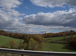
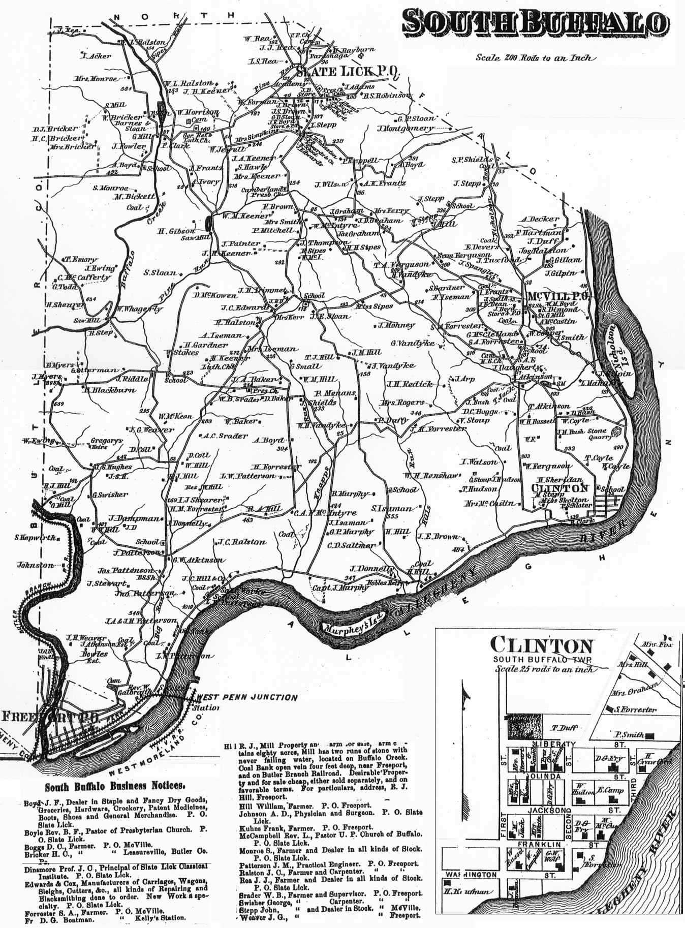
South Buffalo Township is located near the southwestern corner of Armstrong County. The Allegheny River forms the southern and eastern borders of the township, and Butler County lies along the western border. North Buffalo Township is to the north, and the borough of Freeport abuts the southwestern edge of the township in the triangle between the Allegheny River and Butler County. Buffalo Creek flows through the western part of the township, joining the Allegheny at Freeport. Nicholson Island is within the township in the Allegheny River.

According to the United States Census Bureau, the township has a total area of 27.8 square miles (71.9 km2), of which 26.9 square miles (69.8 km2) is land and 0.81 square miles (2.1 km2), or 2.96%, is water. [3]

Demographics

Historical population
CensusPop.Note
2010 2,636
2020 2,7132.9%
2021 (est.)2,695 [2] −0.7%
U.S. Decennial Census [6]

As of the 2000 census, [7] there were 2,785 people, 1,013 households, and 808 families residing in the township. The population density was 102.8 inhabitants per square mile (39.7/km2). There were 1,048 housing units at an average density of 38.7 per square mile (14.9/km2). The racial makeup of the township was 99.21% White, 0.14% African American, 0.04% Asian, and 0.61% from two or more races. Hispanic or Latino of any race were 0.14% of the population.

There were 1,013 households, out of which 30.9% had children under the age of 18 living with them, 71.1% were married couples living together, 5.2% had a female householder with no husband present, and 20.2% were non-families. 17.4% of all households were made up of individuals, and 9.2% had someone living alone who was 65 years of age or older. The average household size was 2.74 and the average family size was 3.11.

The township median age of 40 years was the same as the county median age of 40 years. The distribution by age group was 22.8% under the age of 18, 8.4% from 18 to 24, 28.4% from 25 to 44, 27.3% from 45 to 64, and 13.0% who were 65 years of age or older. The median age was 40 years. For every 100 females, there were 104.2 males. For every 100 females age 18 and over, there were 105.1 males.

The median income for a household in the township was $42,222, and the median income for a family was $46,389. Males had a median income of $36,970 versus $21,895 for females. The per capita income for the township was $18,106. About 3.3% of families and 4.6% of the population were below the poverty line, including 4.8% of those under age 18 and none of those age 65 or over.

Education

It is in the Freeport Area School District. [8]

The district operates South Buffalo Elementary School in the township, while Freeport Area Middle School and Freeport Area High School are in Sarver in Buffalo Township, Butler County. [9] [10]

Cemeteries

Related Research Articles

<span class="mw-page-title-main">Bethel Township, Armstrong County, Pennsylvania</span> Township in Pennsylvania, United States

Bethel Township is a township in Armstrong County, Pennsylvania, United States. The population was 1,096 at the 2020 census, a decrease from the figure of 1,183 tabulated in 2010.

<span class="mw-page-title-main">Boggs Township, Armstrong County, Pennsylvania</span> Township in Pennsylvania, United States

Boggs Township is a township in Armstrong County, Pennsylvania, United States. The population was 813 at the 2020 census, a decrease from the figure of 936 tabulated in 2010.

<span class="mw-page-title-main">Cowanshannock Township, Armstrong County, Pennsylvania</span> Township in Pennsylvania, United States

Cowanshannock Township is a township in Armstrong County, Pennsylvania, United States. The population was 2,742 at the 2020 census, a decrease from the figure of 2,899 tabulated in 2010.

<span class="mw-page-title-main">East Franklin Township, Armstrong County, Pennsylvania</span> Township in Pennsylvania, United States

East Franklin Township is a township in Armstrong County, Pennsylvania, United States. The population was 3,821 at the 2020 census, a decrease from the figure of 4,082 tabulated in 2010.

<span class="mw-page-title-main">Gilpin Township, Armstrong County, Pennsylvania</span> Township in Pennsylvania, United States

Gilpin Township is a Second class Township in Armstrong County, Pennsylvania, United States. At the 2010 census it had a population of 2,496. As of the 2020 census, its population had decreased to 2,411, a 3.4% decrease.

<span class="mw-page-title-main">Kiskiminetas Township, Armstrong County, Pennsylvania</span> Township in Pennsylvania, United States

Kiskiminetas Township is a township in Armstrong County, Pennsylvania, United States. The population was 4,604 at the 2020 census, a decrease from the figure of 4,800 tabulated in 2010, making it the most populous township or borough in the county.

<span class="mw-page-title-main">Kittanning Township, Armstrong County, Pennsylvania</span> Township in Pennsylvania, United States

Kittanning Township is a township in Armstrong County, Pennsylvania, United States. The population was 2,019 at the 2020 census, a decrease from the figure of 2,265 tabulated in 2010.

<span class="mw-page-title-main">Madison Township, Armstrong County, Pennsylvania</span> Township in Pennsylvania, United States

Madison Township is a township in Armstrong County, Pennsylvania, United States. The population was 826 at the 2020 census, an increase over the figure of 820 tabulated in 2010.

<span class="mw-page-title-main">Mahoning Township, Armstrong County, Pennsylvania</span> Township in Pennsylvania, United States

Mahoning Township is a township in Armstrong County, Pennsylvania, United States. The population was 1,406 at the 2020 census, a decrease from 1,425 at the 2010 census.

<span class="mw-page-title-main">Manor Township, Armstrong County, Pennsylvania</span> Township in Pennsylvania, United States

Manor Township is a township in Armstrong County, Pennsylvania, United States. The population was 4,190 at the 2020 census, a decrease from the figure of 4,227 tabulated in 2010.

<span class="mw-page-title-main">North Buffalo Township, Pennsylvania</span> Township in Pennsylvania, United States

North Buffalo Township is a township in Armstrong County, Pennsylvania, United States. The population was 2,698 at the 2020 census, a decrease from the figure of 3,011 tabulated in 2010.

<span class="mw-page-title-main">Parker, Pennsylvania</span> Place in Pennsylvania, United States

Parker is a city located in Armstrong County, Pennsylvania, United States. It is in the extreme northwestern portion of the county. The population was 695 at the 2020 census. The city was named for Judge John Parker, a lead surveyor of Lawrenceburg and founder/owner of Parker's Landing, the two villages combined to create Parker.

<span class="mw-page-title-main">Parks Township, Pennsylvania</span> Township in Pennsylvania, United States

Parks Township is a township in Armstrong County in the U.S. state of Pennsylvania. The population was 2,471 at the 2020 census, a decrease from 2,744 at the 2010 census.

<span class="mw-page-title-main">Perry Township, Armstrong County, Pennsylvania</span> Township in Pennsylvania, United States

Perry Township is a township that is located in Armstrong County, Pennsylvania, United States. The population was 367 at the time of the 2020 census, an increase over the figure of 352 that was tabulated in 2010.

<span class="mw-page-title-main">Pine Township, Armstrong County, Pennsylvania</span> Township in Pennsylvania, United States

Pine Township is a township that is located in Armstrong County, Pennsylvania, United States. The population was 351 at the time of the 2020 census, a decrease from the figure of 412 that was tabulated in 2010.

<span class="mw-page-title-main">Plumcreek Township, Pennsylvania</span> Township in Pennsylvania, United States

Plumcreek Township is a township that is located in Armstrong County, Pennsylvania, United States. The population was 2,106 at the time of the 2020 census, a decrease from the figure of 2,375 that was tabulated in 2010.

<span class="mw-page-title-main">Rayburn Township, Pennsylvania</span> Township in Pennsylvania, United States

Rayburn Township is a township that is located in Armstrong County, Pennsylvania, United States. The population was 1,766 at the time of the 2020 census, a decrease from the figure of 1,907 that was tabulated in 2010.

<span class="mw-page-title-main">South Bend Township, Pennsylvania</span> Township in Pennsylvania, United States

South Bend Township is a township in Armstrong County, Pennsylvania, United States. The population was 1,010 at the 2020 census, a decrease from the figure of 1,167 tabulated in 2010.

<span class="mw-page-title-main">Washington Township, Armstrong County, Pennsylvania</span> Township in Pennsylvania, United States

Washington Township is a township in Armstrong County, Pennsylvania, United States. The population was 898 at the 2020 census, a decrease from 923 at the 2010 census.

<span class="mw-page-title-main">Wayne Township, Armstrong County, Pennsylvania</span> Township in Pennsylvania, United States

Wayne Township is a township that is located in Armstrong County, Pennsylvania, United States.

References

  1. "2016 U.S. Gazetteer Files". United States Census Bureau. Retrieved August 13, 2017.
  2. 1 2 3 Bureau, US Census. "City and Town Population Totals: 2020-2021". Census.gov. US Census Bureau. Retrieved June 29, 2022.
  3. 1 2 "Geographic Identifiers: 2010 Demographic Profile Data (G001): South Buffalo township, Armstrong County, Pennsylvania". U.S. Census Bureau, American Factfinder. Archived from the original on February 10, 2020. Retrieved August 2, 2013.
  4. "National Register Information System". National Register of Historic Places . National Park Service. July 9, 2010.
  5. "Atlas of Armstrong County Pennsylvania, page 69". Pomeroy, Whitman & Co. 1876. Retrieved November 9, 2018.
  6. "Census of Population and Housing". Census.gov. Retrieved June 4, 2016.
  7. "U.S. Census website". United States Census Bureau . Retrieved January 31, 2008.
  8. "2020 CENSUS - SCHOOL DISTRICT REFERENCE MAP: Armstrong County, PA" (PDF). U.S. Census Bureau . Retrieved July 16, 2024. - Text list
  9. "District Map". Freeport Area School District. Retrieved July 16, 2024. - Linked from here
  10. "Zoning Districts Map" (PDF). Buffalo Township . Retrieved July 16, 2024.
  11. "Blue Slate Cemetery". Geographic Names Information System . United States Geological Survey, United States Department of the Interior.
  12. "Buffalo United Presbyterian Church Cemetery". Geographic Names Information System . United States Geological Survey, United States Department of the Interior.
  13. "Freeport Cemetery". Geographic Names Information System . United States Geological Survey, United States Department of the Interior.
  14. "McVille Union Cemetery". Geographic Names Information System . United States Geological Survey, United States Department of the Interior.
  15. "Mud Church Cemetery". Geographic Names Information System . United States Geological Survey, United States Department of the Interior.
  16. "Murphys Cemetery". Geographic Names Information System . United States Geological Survey, United States Department of the Interior.
  17. "Saint Francis DePaul Cemetery". Geographic Names Information System . United States Geological Survey, United States Department of the Interior.
  18. "Saint Marys Cemetery". Geographic Names Information System . United States Geological Survey, United States Department of the Interior.
  19. "Slate Lick Cemetery". Geographic Names Information System . United States Geological Survey, United States Department of the Interior.
  20. "Slate Lick United Presbyterian Cemetery". Geographic Names Information System . United States Geological Survey, United States Department of the Interior.

40°45′15″N79°37′14″W / 40.75417°N 79.62056°W / 40.75417; -79.62056