South Lead Hill, Arkansas | |
---|---|
Coordinates: 36°23′44″N92°54′22″W / 36.39556°N 92.90611°W | |
Country | United States |
State | Arkansas |
County | Boone |
Area | |
• Total | 0.16 sq mi (0.42 km2) |
• Land | 0.16 sq mi (0.42 km2) |
• Water | 0.00 sq mi (0.00 km2) |
Elevation | 860 ft (260 m) |
Population (2020) | |
• Total | 86 |
• Density | 524.39/sq mi (202.75/km2) |
Time zone | UTC-6 (Central (CST)) |
• Summer (DST) | UTC-5 (CDT) |
FIPS code | 05-65480 |
GNIS feature ID | 2407371 [2] |
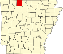
South Lead Hill is a town in Boone County, Arkansas, United States. The population was 102 at the 2010 census. It is part of the Harrison Micropolitan Statistical Area.
According to the United States Census Bureau, the town has a total area of 0.3 km2 (0.1 mi2), all land.
Census | Pop. | Note | %± |
---|---|---|---|
1980 | 85 | — | |
1990 | 96 | 12.9% | |
2000 | 88 | −8.3% | |
2010 | 102 | 15.9% | |
2020 | 86 | −15.7% | |
U.S. Decennial Census [3] |
As of the census [4] of 2000, there were 88 people, 28 households, and 22 families residing in the town. The population density was 261.4/km2 (702.4/mi2). There were 33 housing units at an average density of 98.0/km2 (263.4/mi2). The racial makeup of the town was 93.18% White, 2.27% Native American, and 4.55% from two or more races. 1.14% of the population were Hispanic or Latino of any race.
There were 28 households, out of which 57.1% had children under the age of 18 living with them, 57.1% were married couples living together, 7.1% had a female householder with no husband present, and 21.4% were non-families. 17.9% of all households were made up of individuals, and 10.7% had someone living alone who was 65 years of age or older. The average household size was 3.14 and the average family size was 3.55.
In the town, the population was spread out, with 38.6% under the age of 18, 8.0% from 18 to 24, 31.8% from 25 to 44, 15.9% from 45 to 64, and 5.7% who were 65 years of age or older. The median age was 26 years. For every 100 females, there were 104.7 males. For every 100 females age 18 and over, there were 92.9 males.
The median income for a household in the town was $30,625, and the median income for a family was $41,250. Males had a median income of $28,250 versus $15,000 for females. The per capita income for the town was $15,724. There were no families and 14.9% of the population living below the poverty line, including no under eighteens and none of those over 64.
Public education for elementary and secondary students is provided to South Lead Hill, along with Lead Hill and Diamond City by the Lead Hill School District, which leads to graduation from Lead Hill High School. [5]
Boone County is located in the U.S. state of Arkansas, along the Missouri border. As of the 2020 census, the population was 37,373. The county seat is Harrison. It is Arkansas's 62nd county, formed on April 9, 1869.
Big Flat is a town in Baxter and Searcy counties in the U.S. state of Arkansas. The population was 88 at the 2020 census.
Briarcliff is a second-class city in Baxter County, Arkansas, United States. The population was 236 at the 2010 census.
Alpena is a town in Boone and Carroll counties in the U.S. state of Arkansas. The population was 374 at the 2020 census.
Bellefonte is a town in Boone County, Arkansas, United States. The population was 530 at the 2010 census. It is part of the Harrison Micropolitan Statistical Area. Bellefonte gained national attention in 2013 when the city's mayor, James Wiggs, was recognized as the oldest active mayor in the United States at 90 years of age.
Bergman is a town in Boone County, Arkansas, United States. The population was 439 at the 2010 census. It is part of the Harrison Micropolitan Statistical Area.
Diamond City is a city in northeast Boone County, Arkansas, United States. The population was 782 at the 2010 census. It is part of the Harrison Micropolitan Statistical Area.
Everton is a town in Boone County, Arkansas, United States. The population was 133 at the 2010 census. It is part of the Harrison Micropolitan Statistical Area.
Lead Hill is a town in Boone County, Arkansas, United States. The population was 271 at the 2010 census. It is part of the Harrison Micropolitan Statistical Area.
Valley Springs is a town in Boone County, Arkansas, United States. The population was 175 at the 2010 census. It is part of the Harrison Micropolitan Statistical Area.
Zinc is a town near the east-central edge of Boone County, Arkansas, United States. The population was 92 at the 2020 census. It is part of the Harrison Micropolitan Statistical Area. A chapter of the Ku Klux Klan operates in Zinc.
Amagon is a town in Jackson County, Arkansas, United States. The population was 98 at the 2010 census. It is the birthplace of former Governor of Arkansas Mike Beebe.
Campbell Station is a city in Jackson County, Arkansas, United States. The population was 255 at the 2010 census.
Tupelo is a town in Jackson County, Arkansas, United States. The population was 180 at the 2010 census.
Alicia is a town in Lawrence County, Arkansas, United States. The population was 124 at the 2010 census.
Moro is a town in Lee County, Arkansas, United States. The population was 216 at the 2010 census.
Western Grove is a town in northeastern Newton County, Arkansas, United States. The population was 384 at the 2010 census. It is part of the Harrison Micropolitan Statistical Area.
Traskwood is a city in Saline County, Arkansas, United States. The population was 518 at the 2010 census. It is part of the Little Rock–North Little Rock–Conway Metropolitan Statistical Area.
Caldwell is a town in St. Francis County, Arkansas, United States. The population was 555 at the 2010 census, an increase from 465 in 2000.
Corinth is a town in Yell County, Arkansas, United States. The population was 65 at the 2000 census. It is part of the Russellville Micropolitan Statistical Area.