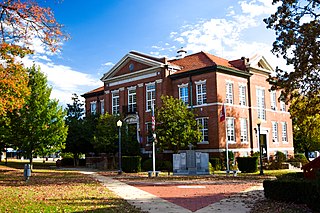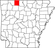
Van Buren County is a county located in the U.S. state of Arkansas. As of the 2020 census, the population was 15,796. The county seat is Clinton. The county was formed on November 11, 1833, and named for Martin Van Buren, President of the United States, who was Vice President at the time of the county's formation. Van Buren County was a dry county until November 3, 2020, as the county residents voted to make it a wet county.

Saline County is a county located in the U.S. state of Arkansas. As of the 2020 census, the population was 123,416. Its county seat and largest city is Benton. Saline County was formed on November 2, 1835, and named for the salt water (brine) springs in the area, despite a differing pronunciation from saline. Until November 2014, it was an alcohol prohibition or dry county.

Pulaski County is a county in the U.S. state of Arkansas. With a population of 399,125 as of the 2020 United States Census, it is the most populous county in Arkansas. The county is included in the Little Rock–North Little Rock–Conway metropolitan area. Its county seat is Little Rock, which is also Arkansas's capital and largest city.

Jefferson County, Arkansas is a county located in the U.S. state of Arkansas in the area known as the Arkansas Delta that extends west of the Mississippi River. Jefferson County consists of five cities, two towns, and 20 townships. It is bisected by the Arkansas River, which was critical to its development and long the chief transportation byway. In 2020, Jefferson County's population was estimated at 67,260. The county seat and largest city is Pine Bluff. The county is included in the Pine Bluff metropolitan statistical area. The county seat and the most populous city is Pine Bluff.

Cleburne County is a county located in the U.S. state of Arkansas. As of the 2020 census, the population was 24,711. The county seat and most populous city is Heber Springs. The county was formed on February 20, 1883, as the last of Arkansas's 75 counties to be formed. It is named for Confederate Major-General Patrick Cleburne. Cleburne is an alcohol prohibition or dry county.

Carroll County is a county located in the U.S. state of Arkansas. As of the 2020 census, the population was 28,260. The county has two county seats, Berryville and Eureka Springs. Carroll County is Arkansas's 26th county, formed on November 1, 1833, and named after Charles Carroll, the last surviving signer of the United States Declaration of Independence.

Boone County is a county located in the U.S. state of Arkansas, along the Missouri border. As of the 2020 census, the population was 37,373. The county seat is Harrison. It is Arkansas's 62nd county, formed on April 9, 1869.
Bellefonte Township is one of 20 current townships in Boone County, Arkansas, USA. As of the 2010 census, its total population was 2,380.
Blythe Township is one of twenty current townships in Boone County, Arkansas, USA. As of the 2010 census, its total population was 245.
Bryan Township is one of twenty current townships in Boone County, Arkansas, USA. As of the 2010 census, its total population was 1,018.
Carrollton Township is one of twenty current townships in Boone County, Arkansas, USA. As of the 2010 census, its total population was 843.
Sugar Loaf Township is one of twenty current townships in Boone County, Arkansas, USA. As of the 2010 census, its total population was 2,320.
Zinc Township is one of twenty current townships in Boone County, Arkansas, USA. As of the 2010 census, its total population was 585.
Jackson Township is one of twenty current townships in Boone County, Arkansas, USA. As of the 2010 census, its total population was 1,340.
Summit Township is one of twenty current townships in Boone County, Arkansas, USA]. At the 2010 census, its total population was 556.
Olvey Township is one of twenty current townships in Boone County, Arkansas, USA. As of the 2010 census, its total population was 440.
Gaither Township is one of twenty current townships in Boone County, Arkansas, USA. As of the 2010 census, its total population was 676.
Ewing Township is one of twenty current townships in Boone County, Arkansas, USA. As of the 2010 census, its total population was 458.
Lee Township is one of twenty current townships in Boone County, Arkansas, USA. As of the 2010 census, its total population was 1,867.
Long Creek Township is one of twenty current townships in Boone County, Arkansas, USA. As of the 2010 census, its total population was 902.


