Bergman | |
---|---|
Coordinates: 36°18′46″N93°00′42″W / 36.31278°N 93.01167°W | |
Country | United States |
State | Arkansas |
County | Boone |
Founded | August 4, 1905 |
Incorporated | April 3, 1968 |
Government | |
• Type | Council government |
• Mayor | Danny Farmer |
Area | |
• Total | 1.31 sq mi (3.38 km2) |
• Land | 1.30 sq mi (3.38 km2) |
• Water | 0.00 sq mi (0.00 km2) |
Elevation | 1,270 ft (390 m) |
Population (2020) | |
• Total | 426 |
• Density | 326.44/sq mi (126.08/km2) |
Time zone | UTC-6 (Central (CST)) |
• Summer (DST) | UTC-5 (CDT) |
ZIP code | 72615 |
Area code | 870 |
FIPS code | 05-05440 |
GNIS feature ID | 2405247 [2] |
Website | townofbergman |
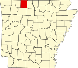
Bergman is a town in Boone County, Arkansas, United States. The population was 439 at the 2010 census. It is part of the Harrison Micropolitan Statistical Area.
According to the United States Census Bureau, the town has a total area of 3.4 km2 (1.3 mi2), all land.
Areas very close to the current location of Bergman were known as Oregon Flat and Clabbie. There was also a town around one mile south of present-day Bergman called Keener. Keener was strong in the 1880s and had a population of about 1,000 people. But, Keener began to decline fast by 1892.
The town of Bergman was first incorporated on August 4, 1905. The name was derived from a Dr. Bergman, who provided the land and requested that it be named after her daughter. Miss Edith Bergman who was the daughter of Dr. Bergman (and hence the person who the town was named after) was the first postmistress.
Like a number of other towns in Boone County, Bergman was a railroad town. The White River Division Railway, which eventually was part of the Missouri Pacific Line, went through Bergman.
Before the increased prevalence of the automobile and better roads in the area such as Arkansas Highway 43 (which was built in 1927 and had been blacktopped by 1948), Bergman had a number of businesses and flourished as a small town. [3]
The current incorporation took place on March 14, 1968. A new post office was located in Bergman in 1974. [4]
Although Bergman has a school district as part of the Arkansas school consolidation of 1929, it is now largely a residential community.
Census | Pop. | Note | %± |
---|---|---|---|
1970 | 249 | — | |
1980 | 320 | 28.5% | |
1990 | 324 | 1.3% | |
2000 | 407 | 25.6% | |
2010 | 439 | 7.9% | |
2020 | 426 | −3.0% | |
U.S. Decennial Census [5] |
As of the census [6] of 2010, there were 445 people, 162 households, and 118 families residing in the town. The population density was 120.9/km2 (312.9/mi2). There were 169 housing units at an average density of 50.2/km2 (129.9/mi2). The racial makeup of the town was 96.81% White, 0.49% Native American, 0.25% Asian, 0.25% Pacific Islander, 0.49% from other races, and 1.72% from two or more races. 0.74% of the population were Hispanic or Latino of any race.
There were 155 households, out of which 44.5% had children under the age of 18 living with them, 57.4% were married couples living together, 9.7% had a female householder with no husband present, and 28.4% were non-families. 26.5% of all households were made up of individuals, and 11.0% had someone living alone who was 65 years of age or older. The average household size was 2.63 and the average family size was 3.19.
In the town, the population was spread out, with 31.0% under the age of 18, 8.6% from 18 to 24, 31.9% from 25 to 44, 18.4% from 45 to 64, and 10.1% who were 65 years of age or older. The median age was 33 years. For every 100 females, there were 105.6 males. For every 100 females age 18 and over, there were 100.7 males.
The median income for a household in the town was $31,250, and the median income for a family was $37,708. Males had a median income of $27,778 versus $18,958 for females. The per capita income for the town was $13,928. About 7.3% of families and 10.6% of the population were below the poverty line, including 9.8% of those under age 18 and 21.4% of those age 65 or over.
Bergman, along with Zinc, is within the Bergman School District, which leads to graduation to Bergman High School. [7]
Boone County is located in the U.S. state of Arkansas, along the Missouri border. As of the 2020 census, the population was 37,373. The county seat is Harrison. It is Arkansas's 62nd county, formed on April 9, 1869.
Big Flat is a town in Baxter and Searcy counties in the U.S. state of Arkansas. The population was 88 at the 2020 census.
Briarcliff is a second-class city in Baxter County, Arkansas, United States. The population was 236 at the 2010 census.
Alpena is a town in Boone and Carroll counties in the U.S. state of Arkansas. The population was 374 at the 2020 census.
Bellefonte is a town in Boone County, Arkansas, United States. The population was 530 at the 2010 census. It is part of the Harrison Micropolitan Statistical Area. Bellefonte gained national attention in 2013 when the city's mayor, James Wiggs, was recognized as the oldest active mayor in the United States at 90 years of age.
Everton is a town in Boone County, Arkansas, United States. The population was 133 at the 2010 census. It is part of the Harrison Micropolitan Statistical Area.
South Lead Hill is a town in Boone County, Arkansas, United States. The population was 102 at the 2010 census. It is part of the Harrison Micropolitan Statistical Area.
Valley Springs is a town in Boone County, Arkansas, United States. The population was 175 at the 2010 census. It is part of the Harrison Micropolitan Statistical Area.
Zinc is a town near the east-central edge of Boone County, Arkansas, United States. The population was 92 at the 2020 census. It is part of the Harrison Micropolitan Statistical Area. A chapter of the Ku Klux Klan operates in Zinc.
Horseshoe Lake is a town in Crittenden County, Arkansas, United States. The population was 264 at the 2020 census.
Campbell Station is a city in Jackson County, Arkansas, United States. The population was 255 at the 2010 census.
Alicia is a town in Lawrence County, Arkansas, United States. The population was 124 at the 2010 census.
Moro is a town in Lee County, Arkansas, United States. The population was 216 at the 2010 census.
Allport is a town in Lonoke County, Arkansas, United States. Although a black enclave in the largely-white Lonoke County since the 1870s, the town did not incorporate until 1967 in order to receive funding for municipal services. Located within Central Arkansas along Highway 165, the community's economy is strongly tied to agriculture. The population was 115 at the 2010 Census.
Western Grove is a town in northeastern Newton County, Arkansas, United States. The population was 384 at the 2010 census. It is part of the Harrison Micropolitan Statistical Area.
Traskwood is a city in Saline County, Arkansas, United States. The population was 518 at the 2010 census. It is part of the Little Rock–North Little Rock–Conway Metropolitan Statistical Area.
Williford is a town in Sharp County, Arkansas, United States. The population was 70 in 2020
Caldwell is a town in St. Francis County, Arkansas, United States. The population was 555 at the 2010 census, an increase from 465 in 2000.
Goshen is a city in Washington County, Arkansas, United States. The population was 2,102 at the 2020 census. It is part of the Northwest Arkansas region. According to Business Insider, it is the “most educated” city in the state of Arkansas.
Corinth is a town in Yell County, Arkansas, United States. The population was 65 at the 2000 census. It is part of the Russellville Micropolitan Statistical Area.