
Wakefield is a village in the town of South Kingstown, Rhode Island, and the commercial center of the town. Together with the village of Peace Dale, it is treated by the U.S. Census as a component of the census-designated place identified as Wakefield-Peacedale, Rhode Island. West Kingston, another South Kingstown village, was the traditional county seat of Washington County. Since 1991, the Washington County Courthouse has been in Wakefield. The Sheriff's Office which handles corrections is also in Wakefield.

The Mechanic Street Historic District encompasses a historic 19th-century mill and mill village in a 14-block area of the Pawcatuck section of Stonington, Connecticut. Extending along the Pawcatuck River and south of West Broad Street, the area includes a large brick mill complex on the banks of the river, and a neighborhood of well-preserved worker housing on the road grid to its west. The district was listed on the National Register of Historic Places in 1988.

Carolina is a village that straddles the border of the towns of Charlestown and Richmond on the Pawcatuck River in Washington County, Rhode Island. Rhode Island Route 112 passes through the village. Carolina is identified as a census-designated place for reporting of data from the 2010 census.

The South Central Falls Historic District is a historic district in Central Falls, Rhode Island. It is a predominantly residential area, densely populated, which was developed most heavily in the late 19th century. It is bounded roughly by Broad Street to the east, the Pawtucket city line to the south, Dexter Street to the west, and Rand Street and Jenks Park to the north. It has 377 contributing buildings, most of which were built before 1920. The district was added to the National Register of Historic Places in 1991.

The Providence Jewelry Manufacturing Historic District is a predominantly industrial historic district in Providence, Rhode Island. It covers a roughly 19-acre (7.7 ha) area just south of Downtown Providence, and was originally bounded by Interstate 195 prior to a realignment in the 2000s which reconnected the two areas. Although the area began as a residential area, and still has some houses in it, it developed in the late 19th and early 20th centuries as a center of Providence's jewelry manufacturing businesses. The oldest industrial building in the district is the 1848 Elm Street Machine Shop, a 2 1⁄2-story stone structure that now houses offices of Brown University.

The Hope Village Historic District encompasses a historic mill village located in Scituate, Rhode Island. Located on a bend in the Pawtuxet River in southeastern Scituate, the area has seen industrial activity since the 18th century, and has surviving industrial and residential buildings from the early 19th century. The village is centered on the junction of Main Street and North Road, and radiates out from there, with numerous properties on smaller side streets. The present main mill building was built in 1844 by Brown & Ives, operators of numerous Rhode Island textile mills. Approximately 1/4 of the village's housing stock originated as mill worker housing built by the company.
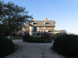
The Ocean Road Historic District is a residential historic district, encompassing an area of fashionable summer houses built in the late 19th and early 20th centuries in Narragansett, Rhode Island. The area is located south of The Towers, the center of the Narragansett Pier area, extending along Ocean Road roughly from Hazard Street to Wildfield Farm Road. Many of the 45 houses in the district were built between about 1880 and 1900, with a few built earlier and later. The Shingle style is prominent in the architectural styles found, including among houses designed by architects, including McKim, Mead & White and William Gibbons Preston. The most unusual property is called Hazard's Castle, a rambling stone structure built beginning in the 1840s by Joseph Peace Hazard, who was a major landowner in the area prior to its development in the 1880s.

The Shannock Historic District is a historic mill village located along the Pawcatuck River in the towns of Richmond and Charlestown, Rhode Island. The postal code for Shannock is 02875. The village extends along Old Shannock Road, Railroad Street, and Shannock Village Road between two crossings of the Pawcatuck, which forms the border between the two towns. It lies mainly in Richmond, but extends along the road running southwest and southeast from the two crossings. Two mill complexes are the visual focal points of the village: the Carmichael plant on the west, and the Columbia Narrow Fabrics Company complex near the village center. The buildings in the village are predominantly residential worker housing set close to the road, which were built in the second half of the 19th century. There are two imposing Greek Revival houses, both built c. 1850, and one Late Victorian house, all of which belonged to mill owners. The area was listed on the National Register of Historic Places in 1983.

Wyoming is a village and census-designated place on the Wood River in southern Rhode Island, primarily in the town of Richmond, Rhode Island, but extending north across the river into the town of Hopkinton, Rhode Island. It is the site of the Wyoming Village Historic District and a post office assigned ZIP code 02898.

The Main Street Historic District is a small residential historic district south of the downtown area of Auburn, Maine. The fourteen houses in the district represent a cross-section of residential development during Auburn's growth between about 1825 and 1925. The district extends along Main Street, from Drummond Street south just past Elm Street, and includes a few houses on Elm and Vine Streets. The district was added to the National Register of Historic Places in 1989.

The East Blackstone Village Historic District is a historic district roughly along Elm Street at the junction with Summer Street in eastern Blackstone, Massachusetts. It encompasses a small 19th-century mill village center that developed along what was once a major roadway connecting Worcester with Providence, Rhode Island. The district was added to the National Register of Historic Places in 1995.

The Prospect Hill Historic District encompasses a large residential area in the Willimantic section of Windham, Connecticut. Located north of the Main Street commercial district, it was developed between about 1865 and 1930, and is one of the state's largest historic districts, with more than 800 contributing buildings. It is roughly bounded by Valley, Jackson, Bolivia, Washburn, Windham, and High Streets, and contains one of the state's largest single concentrations of Victorian-era residential architecture. It was listed on the National Register of Historic Places in 2003.

The Attleborough Falls Historic District is a predominantly residential historic district on Mt. Hope and Towne Streets in North Attleborough, Massachusetts. Located just south of the Ten Mile River, it encompasses a stylish mid-to-late 19th century residential area that developed in a previously rural area due to industrial development across the river. The district was added to the National Register of Historic Places in 2004.

The Hatfield Center Historic District encompasses the traditional center of Hatfield, Massachusetts. The area, first laid out in 1661, is bounded by Maple Street to the south, the Connecticut River to the east, Day Avenue and School Street to the north, and the Mill River to the west. The area's layout and land use patterns are relatively little altered since they were laid out, leaving a well-preserved early colonial village landscape. The district was added to the National Register of Historic Places in 1994.

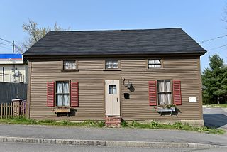
The William Jillson Stone House is a historic house museum at 561 Main Street inside Jillson Square Park, in the Willimantic section of Windham, Connecticut. Built in 1825-27, it is a rare local instance of a stone house, built by one of the area's early industrialists. It is now maintained by the Windham Historical Society, and was listed on the National Register of Historic Places in 1971.

The Manville Company Worker Housing Historic District is a residential historic district encompassing an area of mill worker housing in the Manville village of Lincoln, Rhode Island. The district covers about 50 acres (20 ha) of the village, including properties on Angle, Main, Old Main, Spring, Summer, Winter, and Chestnut Streets, as well as several properties on adjoining roads, describing a crescent, part of which abuts the south bank of the Blackstone River. The housing in this district was built between about 1812 and 1890 by the various proprietors of the Manville Company, and feature a diversity of architectural styles, most of which are simple vernacular interpretations of styles popular at the time. Most of the houses are either 1-1/2 or 2-1/2 stories in height, with one or two units per structure, and are set on small lots. There are also a series of brick rowhouses, a relative rarity in Rhode Island mill housing of the period.

The Exeter Waterfront Commercial Historic District encompasses the historic commercial and residential waterfront areas of Exeter, New Hampshire. The district extends along the north side of Water Street, roughly from Main Street to Front Street, and then along both sides of Water and High streets to the latter's junction with Portsmouth Street. It also includes properties on Chestnut Street on the north side of the Squamscott River. This area was where the early settlement of Exeter took place in 1638, and soon developed as a shipbuilding center. The district was listed on the National Register of Historic Places in 1980. It was enlarged in 1986 to include the mill complex of the Exeter Manufacturing Company on Chestnut Street.

The Jewell Town District of South Hampton, New Hampshire, encompasses a colonial-era industrial village with a history dating to 1687. It is centered at the junction of West Whitehall and Jewell Streets, which is just south of a bend in the Powwow River, the source of the power for the mills that were built here. The area was settled in 1687 by Thomas Jewell, and by the early 19th century included a variety of mills as well as a bog iron works. The district now includes only remnants of its industrial past, and features a collection of 18th and early-19th century residential architecture. The district was listed on the National Register of Historic Places in 1983.
The Bond Street Historic District is a residential historic district on Bond Street in Augusta, Maine, United States. The district comprises seven residential buildings built primarily in 1884 by Edwards Manufacturing Company, which was a textile manufacturer in the area. The buildings housed mill workers and their families from 1878, when the first building was constructed until 1946, when the properties were sold to private owners. The buildings are the only surviving mill worker housing in Augusta. The district was listed on the National Register of Historic Places in 2014.
The Dennysville Historic District encompasses the historic town center of Dennysville, Maine. Located near the southern end of the large rural community, its architecture covers more than 100 years of community history, from the early 19th to early 20th centuries. The district extends along Main Street between Maine State Route 86 and Bunker Hill Road, on the west bank of the Dennys River. It was listed on the National Register of Historic Places in 1982.


