The road begins at the interchange of US 41 and SR State Road 80-82-867, historically known as the Five Points Interchange. The road briefly overlaps SR 80 along Main and Monroe Streets, where it becomes discontinuous (it once continued east along with SR 80 though downtown along the then-one-way First Street and Second Street but those streets were turned over to city control in 2006).[1]
Business US 41 resumes along SR 739 at SR 80, where it runs along Park Avenue (northbound) and Fowler Street (southbound) until they reach the Edison Bridge where the two streets merge. After crossing over the Caloosahatchee River BUS 41 enters North Fort Myers where it briefly becomes a six-lane undivided highway only for the divider to return north of Cabanna Avenue. The road heads north, intersecting with State Road 78. Between State Road 78 and Powell Drive, the road becomes a four-lane divided highway for the remainder of the route. The road finally ends at a former wye at US 41.
U.S. Route 41 Business is a former segment of U.S. Route 41 and an existing segment of the Tamiami Trail in Venice, Florida that begins near Shamrock Boulevard in Venice Gardens and terminates at Venetia Bay Boulevard in the Eastgate section of Venice. The existing US 41 in Venice runs along the Venice Bypass (hidden SR 45A).
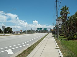
Southbound US 41 approaching Venice business loop. Note the movement of Tamiami Trail away from mainline US 41.
U.S. Route 41 Business is an alternate route and former segment of U.S. Route 41 in Bradenton, Florida that begins at State Road 684 (Cortez Boulevard West) where it runs along 14th Street until it makes a sharp right turn onto 8th Avenue West and then makes another sharp left onto 9th Street West before intersecting with State Road 64 on eastbound 6th Avenue West and westbound Manatee Avenue West. The road continues north as it passes by South Florida Museum and Bradenton Riverwalk before crossing the Green Bridge and moving onto 8th Avenue W in Palmetto where it intersects 10th Street West, which leads to State Road 43 where the northern concurrency of U.S. Route 41 and U.S. Route 301. As 8th Avenue West passes by 21st Street West, it becomes Valencia Drive and curves to the northeast before terminating at an interchange with US 41 just south of the interchange between US 41 and US 19 in Memphis.
Major intersections The entire route is in Manatee County.
U.S. Route 41 Business is an alternate route to U.S. Route 41 in Tampa, Florida that begins on the Nebraska Avenue-Florida Avenue apex in Lutz and continues south on Florida Avenue. Just south of Hillsborough Avenue (U.S. Route 92), Florida Avenue becomes a one-way street and the south-bound portion splits off into Highland Avenue and later Tampa Street until Downtown Tampa. The route joins State Road 60 at the one way couplet of Kennedy Boulevard (northbound) and Jackson Street (southbound). Jackson Street rejoins Kennedy Boulevard at Meridian Avenue in the Channelside District and the route continues east for 3 blocks until turning north on Channelside Drive. Shortly after, the route makes a slight curve east onto Adamo Drive until the two routes depart at 21st Street (southbound) and 22nd Street (northbound). The route continues south and 21st Street merges back with 22nd Street shortly before a parclo interchange with SR 618 (Selmon Expressway) and crosses over McKay Bay along the Licata Bridge. The route makes a slight curve and continues east as Causeway Boulevard until it reaches its southern terminus near Port Tampa Bay at US 41 (50th Street) and State Road 676 (Causeway Boulevard).
U.S. Route 541 was created in 1931 as a western alternate to US 41 between Palmetto and Tampa; US 41 then followed the present US 301 between those points. In 1938, US 41 was moved from Tampa north to Lutz, and the old route became an extension of US 541. US 541 was eliminated in 1951; the route north from Tampa became US 41 Business, while south from Tampa it became US 41, with old US 41 becoming an extension of US 301.
U.S. Route41 Business (US41 Bus.) is a 7.0-mile-long (11.3km)business route of US41 that travels through the city of Valdosta, Georgia, along with State Route7 Business (SR7 Bus.). It utilizes the former path of US41 and SR7 through the city, while US41/SR7 has been rerouted to Inner Perimeter Road around the eastern edges of the city. The entire length of US41 Bus. is part of the National Highway System, a system of routes determined to be the most important for the nation's economy, mobility, and defense.[5]
Major intersections The entire route is in Lowndes County.
U.S. Route41 Business (US41 Bus.) begins at the northern terminus of the US41/US129 overlap, where it shares a concurrency with Georgia State Route 49 (SR49). Along the way, US80/SR22 joins the concurrency. When US80/US129 intersects Walnut Street, US41 Bus./SR49 turns left and travels concurrent with SR22 until the intersection with Second Street, where that route turns north. US41 Bus. turns south at Spring Street, where SR49 turns north and it is joined by another concurrency with SR19. US41 Bus./SR19 travels south until turning west at Georgia Avenue until splitting into a one-way pair at the intersection with College Street. From that point, northbound US41 Bus./SR49 continues west along Georgia Avenue until it reaches Hardeman Avenue, while southbound US41 Bus./SR49 travels east along Forsyth Road then turns north along College Street. After a split-diamond interchange with Interstate75 (I-75; exit 149) and SR540 where the northbound routes go over the Joe A. Witherington Bridge while the southbound routes go over the Raymond Berry Oakley III Bridge, the one-way pair ends as Hardeman Avenue and Forsyth Street converge and becomes Vineville Avenue. US41 Bus. terminates at US41 and SR247, while SR19 continues along Vineville Avenue, joined by US41 until it terminates in Forsyth. The portion of US41 Bus. from the northern end of the US80 and US129/SR11 concurrencies to the northern terminus, is part of the National Highway System, a system of routes determined to be the most important for the nation's economy, mobility, and defense.[7]
U.S. Route 41 Alternate (signed U.S. Route 41A in Tennessee), as of 2005, has a northern terminus in Hopkinsville, Kentucky, 10 miles (16km) north of the Tennessee line. It serves the city of Clarksville, Tennessee on its way to Nashville, where it briefly runs concurrently with US 41. It then separates again to serve Shelbyville, Winchester, and Tullahoma before rejoining the main route atop Monteagle Mountain. US 41A runs west of US 41 for its entire length, aside from one mile (1.6km) in downtown Nashville, where they are concurrent. US-41A is also concurrent with U.S. Route 31A from Nashville to Triune, Tennessee, for a distance of approximately 25 miles (40km).
U.S. Route41A Bypass (US41A Byp.) is a bypass of the city of Clarksville, Tennessee, on its south side. It first splits off from the US41A mainline at 2nd Street and Kraft, following Riverside Drive south, running concurrently with SR13 and SR12, along the Cumberland River to an intersection with SR48 (College Street). It becomes concurrent with SR 48 and they travel south and leave town to an intersection with Cumberland Drive, where SR13 and SR48 split off to continue southward. The bypass then curves to the east, still following the river, and enters some neighborhoods and comes to an intersection with Ashland City Road, where SR12 splits off and goes toward Ashland City. US41A Byp. then continues east and comes to an end at an intersection with US41A (Madison Street) and SR76 (M.L.K. Jr. Parkway). Most of the road is a two-lane highway, occasionally widening to three lanes to accommodate truck traffic on hills.
U.S. Route 41 Truck (US41 Truck) is a 5.516-mile (8.877km)truck route designed for thru traffic, mainly trucks, through Hopkinsville, Kentucky. It follows Interstate 169 from exit 7 to exit 12, and Kentucky Route 1682 west from the interchange to U.S. 41 north of Hopkinsville.
Known and referred to locally as "US41A" but signed as "Alternate US41," this highway follows what was the original route of US41 between the cities of Madisonville and Henderson, Kentucky. It travels largely from east to west from its southern terminus at US41 on Madisonville's north side until reaching Kentucky Route 814 (KY814) east of Providence. From that point, the highway begins its turn toward the north, passing mostly through rural areas but also serving the small communities of Dixon and Poole. Major highways intersecting the route include:
U.S. Route41 Business (US41 Bus.) was a business route of US41 that existed in Clayton and Fulton counties. It partially traveled in Atlanta. At least as early as 1919, SR3 traveled on essentially the same path as it currently does in the northern part of Clayton County and the southeastern part of Fulton County.[14] By the end of 1926, US41 had been designated on the entire length of SR3 in these counties. The segment of the highway from just north-northwest of the Henry–Clayton county line to Marietta had a "completed hard surface".[15][16] By the end of 1929, US19 was designated on SR3 in the two counties to the main part of Atlanta.[16][17]
In 1953, US19/US41/SR3 was shifted eastward onto the "Expressway" (the precursor of Interstate75 (I-75)) in the southern part of Atlanta, traveled west on Lakewood Avenue, and then resumed the northern path. The former path became US19 Bus./US41 Bus.[10][11] By the end of 1965, US19/US41/SR3 was shifted onto the former path of US19 Bus./US41 Bus. in the Atlanta area.[12][13]
U.S. Route41 Alternate (US41 Alt.) was an alternate route of US41 that existed from Atlanta to Marietta, Georgia. It traversed portions of Fulton and Cobb counties. At least as early as 1919, SR3 traveled on essentially the same path as it currently does in these two cities.[14] By the end of 1926, US41 had been designated on the entire length of SR3 from Atlanta to Marietta. This entire portion of US41/SR3 had a "completed hard surface".[15][16] By the end of 1929, US19 was designated on this segment of highway.[16][17]
Late in 1937, SR3 was split into two parts between Atlanta and the northwest part of Marietta.[21][22] By the end of the year, SR3W was established, traveling northwest with US41 on Marietta Street and Old Marietta Road.[22][23] By the end of 1946, SR3W in Atlanta and Marietta was redesignated as part of the SR3 mainline.[24][18] By February 1948, the segment of US41 on SR3W in this area was redesignated as US41 Alt.[18][19] By April 1949, US41 Alt. was redesignated as US41 Byp.[19][20]
U.S. Route41 Bypass (US41 Byp.) was a bypass route of US41 that existed from Atlanta to Marietta, Georgia. It traversed portions of Fulton and Cobb counties. At least as early as 1919, SR3 traveled on essentially the same path as it currently does in these two cities.[14] By the end of 1926, US41 had been designated on the entire length of SR3 from Atlanta to Marietta. This entire segment of US41/SR3 had a "completed hard surface".[15][16]
Late in 1937, SR3 was split into two parts between Atlanta and the northwest part of Marietta.[21][22] By the end of the year, SR3W was established, traveling northwest with US41 on Marietta Street and Old Marietta Road, while SR3E traveled north-northwest on Hemphill Street and Northside Drive.[22][23] By the end of 1946, SR3W was redesignated as part of the SR3 mainline.[24][18] By February 1948, the segment of US41 on SR3W in this area was redesignated as US41 Alt.[18][19] By April 1949, US41 Alt. was redesignated as US41 Byp.[19][20] By the middle of 1950, US41 Byp. was redesignated as part of the US41 mainline.[20][25]
U.S. Route41 Temporary (US41 Temp.) was a temporary iteration of US41 that existed from Atlanta to Marietta, Georgia. It traversed portions of Fulton and Cobb counties. At least as early as 1919, SR3 traveled on essentially the same path as it currently does in these two cities.[14] By the end of 1926, US41 had been designated on the entire length of SR3 from Atlanta to Marietta. This entire segment of US41/SR3 had a "completed hard surface".[15][16]
Late in 1937, SR3 was split into two parts between Atlanta and the northwest part of Marietta. US41/SR3 traveled northwest on the original path, while SR3E traveled on a more easterly path between the two cities. SR3E's path from SR120 in the east part of Marietta to US41/SR3 in the northwestern part of the city had completed grading, but was not surfaced. The rest of SR3E was under construction.[21][22] By the end of the year, SR3E traveled north-northwest on Hemphill Street and Northside Drive. All of SR3E in the northern part of Atlanta was hard surfaced. From the north part of the city to the northwest part, the highway had completed grading, but was not surfaced.[22][23] Later that year, all of SR3E from Atlanta to northwest of the Fulton–Cobb county line had a completed hard surface.[23][27]
In 1940, nearly the entire segment of SR3E in Marietta had a completed hard surface. It was under construction from northwest of the Fulton–Cobb county line to the eastern part of Marietta.[28][29] By the end of the next year, the entire length of SR3E had a completed hard surface.[30][31] By February 1948, SR3E was moved off of Hemphill Avenue. It, along with US41 Temp., followed US19 on Spring Street, then traveled west on 14th Street and resumed the Northside Drive path.[18][19] By April 1949, US41 Temp./SR3E's southbound lanes traveled on Hemphill Avenue.[19][20] By the middle of 1950, US41 Temp./SR3E was shifted off of US19 on Spring Street and 14th Street, and traveled on Hemphill Avenue again.[20][25] In 1952, US41 Temp. was redesignated as part of the US41 mainline, which was shifted off of SR3W and onto SR3E.[26][10]
U.S. Route41 Toll (US41 Toll) was the original designation for the Tri-State Tollway, which opened in 1958. The toll route entirely followed the Tri-State Tollway and Kingery Expressway from Hammond, Indiana to Wadsworth, Illinois.[33] By 1966, all U.S. toll routes on the Illinois Tollway system, including US41 Toll, were removed, leaving I-94 and I-294 behind.[32][34]
Business US Highway 41 (Bus. 41) was a state trunkline highway that served as a business loop off US41 in Michigan through the city of Marquette along Washington and Front streets after the construction of an expressway bypass of downtown. Jurisdiction over the two streets was transferred to the city as part of a route swap that resulted in the decommissioning of the trunkline. It was also previously co-designated Bus. M-28, mirroring the Bus. US41/Bus. M-28 designations along Bus.M-28 in Ishpeming and Negaunee.
Business U.S. Highway 41 (Bus. US41) served Ishpeming and Negaunee is the only one of the three former business loops in Michigan that is still a state-maintained highway, although it is no longer designated Bus. US41. US41/M-28 was relocated to bypass the two cities' downtowns in 1937.[38][39] The highway through downtown Ishpeming and Negaunee was redesignated US41A/M-28A at the time[41] The Michigan State Highway Department later redesignated it Alt. US41/Alt. M-28.[42] Eventually it carried the Bus. US41/Bus. M-28 designation before being designated just Bus. M-28 in 1958.[43][40]
Business U.S. Highway 41 (Bus. US41) existed in Baraga in the early 1940s. As shown on the maps of the time, US41 was relocated in Baraga between the publication of the December 1, 1939, and the April 15, 1940, MSHD maps.[44][45] A business loop followed the old routing through downtown. The last map that shows the loop was published on July 1, 1941.[47] Bus. US41 is shown under local control on the June 15, 1942, map.[46]
1 2 3 State Highway Department of Georgia (January 1, 1953). System of State Roads(PDF) (Map). Scale not given. Atlanta: State Highway Department of Georgia. Retrieved April 13, 2017. (Corrected to January 1, 1953.)
1 2 State Highway Department of Georgia (January 1966). Official Highway Map(PDF) (Map). Scale not given. Atlanta: State Highway Department of Georgia. Retrieved April 13, 2017.
1 2 3 4 State Highway Department of Georgia (1921). System of State Roads(PDF) (Map). Scale not given. Atlanta: State Highway Department of Georgia. Retrieved April 13, 2017.
1 2 3 4 5 6 State Highway Department of Georgia (October 1926). System of State Roads(PDF) (Map). Scale not given. Atlanta: State Highway Department of Georgia. Retrieved April 13, 2017.
1 2 State Highway Department of Georgia (October 1929). System of State Roads(PDF) (Map). Scale not given. Atlanta: State Highway Department of Georgia. Retrieved April 13, 2017.
1 2 3 4 5 6 7 State Highway Department of Georgia (1946). System of State Roads(PDF) (Map). Scale not given. Atlanta: State Highway Department of Georgia. OCLC5673161. Retrieved April 13, 2017. (Corrected to November 7, 1946.)
1 2 3 4 5 6 7 8 9 10 State Highway Department of Georgia (1948). System of State Roads(PDF) (Map). Scale not given. Atlanta: State Highway Department of Georgia. OCLC5673161. Retrieved April 13, 2017. (Corrected to February 28, 1948.)
1 2 3 4 5 6 7 8 State Highway Department of Georgia (1949). System of State Roads(PDF) (Map). Scale not given. Atlanta: State Highway Department of Georgia. OCLC5673161. Retrieved April 13, 2017. (Corrected to April 1, 1949.)
1 2 3 State Highway Department of Georgia (July 1, 1937). System of State Roads(PDF) (Map). Scale not given. Atlanta: State Highway Department of Georgia. Retrieved April 13, 2017.
1 2 3 4 5 6 State Highway Department of Georgia (October 1, 1937). System of State Roads(PDF) (Map). Scale not given. Atlanta: State Highway Department of Georgia. Retrieved April 13, 2017.
1 2 3 4 Georgia State Highway Board (January 1, 1938). System of State Roads(PDF) (Map). Scale not given. Atlanta: State Highway Department of Georgia. OCLC5673161. Retrieved April 13, 2017.
1 2 State Highway Department of Georgia (January 1, 1945). System of State Roads(PDF) (Map). Scale not given. Atlanta: State Highway Department of Georgia. OCLC5673161. Retrieved April 13, 2017.
1 2 3 State Highway Department of Georgia (1950). System of State Roads(PDF) (Map). Scale not given. Atlanta: State Highway Department of Georgia. OCLC5673161. (Corrected to August 1, 1950.)
1 2 State Highway Department of Georgia (1952). System of State Roads(PDF) (Map). Scale not given. Atlanta: State Highway Department of Georgia. OCLC5673161. (Corrected to January 1, 1952.)
↑ State Highway Department of Georgia (September 1, 1938). System of State Roads(PDF) (Map). Scale not given. Atlanta: State Highway Department of Georgia. OCLC5673161.
↑ State Highway Department of Georgia (April 1, 1940). System of State Roads(PDF) (Map). Scale not given. Atlanta: State Highway Department of Georgia. OCLC5673161.
↑ State Highway Department of Georgia (October 1, 1940). System of State Roads(PDF) (Map). Scale not given. Atlanta: State Highway Department of Georgia. OCLC5673161.
↑ State Highway Department of Georgia (July 1, 1941). System of State Roads(PDF) (Map). Scale not given. Atlanta: State Highway Department of Georgia. OCLC5673161.
↑ State Highway Department of Georgia (January 1, 1942). System of State Roads(PDF) (Map). Scale not given. Atlanta: State Highway Department of Georgia. OCLC5673161.
1 2 Illinois Division of Highways; Rand McNally (1966). Illinois Official Highway Map (Map). [1:772,500]. Springfield: Illinois Division of Highways – via Illinois Digital Archives.
↑ Illinois Division of Highways; Rand McNally (1965). Illinois Official Highway Map (Map). [1:757,500]. Springfield: Illinois Division of Highways – via Illinois Digital Archives.
1 2 Michigan State Highway Department & Rand McNally (May 15, 1937). Official Michigan Highway Map (Map) (Summered.). [c. 1:850,000]. Lansing: Michigan State Highway Department. §B5. OCLC12701143. Retrieved October 17, 2019– via Michigan History Center.
1 2 Michigan State Highway Department & Rand McNally (December 1, 1937). Official Michigan Highway Map (Map) (Wintered.). [c. 1:850,000]. Lansing: Michigan State Highway Department. §B5. OCLC12701143. Retrieved October 17, 2019– via Michigan History Center.
1 2 Michigan State Highway Department (1958). Official Highway Map (Map). [c. 1:918,720]. Lansing: Michigan State Highway Department. §C5. OCLC12701120, 51856742. Retrieved October 17, 2019– via Michigan History Center. (Includes all changes through July 1, 1958)
↑ Marquette County Road Commission (1939). Marquette County (Map). Scale not given. Ishpeming, MI: Marquette County Road Commission.
↑ Marquette County Road Commission (1950). Marquette County (Map). Scale not given. Ishpeming, MI: Marquette County Road Commission.
↑ Michigan State Highway Department (1951). City of Ishpeming Act 51 Map (Map). Scale not given. Lansing: Michigan State Highway Department.
1 2 Michigan State Highway Department & Rand McNally (December 1, 1939). Official Michigan Highway Map (Map) (Wintered.). [c. 1:850,000]. Lansing: Michigan State Highway Department. §B4. OCLC12701143. Retrieved October 17, 2019– via Michigan History Center.
1 2 Michigan State Highway Department & Rand McNally (April 15, 1940). Official Michigan Highway Map (Map) (Springed.). [c. 1:850,000]. Lansing: Michigan State Highway Department. §B4. OCLC12701143.
1 2 Michigan State Highway Department & Rand McNally (June 1, 1942). Official Michigan Highway Map (Map) (Summered.). [c. 1:850,000]. Lansing: Michigan State Highway Department. §B4. OCLC12701143.
↑ Michigan State Highway Department & Rand McNally (July 1, 1941). Official Michigan Highway Map (Map) (Summered.). [c. 1:850,000]. Lansing: Michigan State Highway Department. §B4. OCLC12701143. Archived from the original on April 22, 2017. Retrieved January 2, 2017– via Archives of Michigan.
This page is based on this Wikipedia article Text is available under the CC BY-SA 4.0 license; additional terms may apply. Images, videos and audio are available under their respective licenses.