Demographics
2010 census
As of the census [13] of 2010, there were 154 people, 60 households, and 47 families residing in the city. The population density was 570.4 inhabitants per square mile (220.2/km2). There were 77 housing units at an average density of 285.2 per square mile (110.1/km2). The racial makeup of the city was 96.8% White, 0.6% African American, and 2.6% from two or more races. Hispanic or Latino of any race were 2.6% of the population.
There were 60 households, of which 30.0% had children under the age of 18 living with them, 66.7% were married couples living together, 11.7% had a female householder with no husband present, and 21.7% were non-families. 20.0% of all households were made up of individuals, and 8.3% had someone living alone who was 65 years of age or older. The average household size was 2.57 and the average family size was 2.94.
The median age in the city was 42.7 years. 29.9% of residents were under the age of 18; 1.9% were between the ages of 18 and 24; 19.4% were from 25 to 44; 24.6% were from 45 to 64; and 24% were 65 years of age or older. The gender makeup of the city was 48.1% male and 51.9% female.
2000 census
As of the census of 2000, there were 157 people, 64 households, and 44 families residing in the city. The population density was 596.7 inhabitants per square mile (230.4/km2). There were 73 housing units at an average density of 277.4 per square mile (107.1/km2). The racial makeup of the city was 98.73% White, 0.64% Native American and 0.64% Asian.
There were 64 households, out of which 31.3% had children under the age of 18 living with them, 59.4% were married couples living together, 6.3% had a female householder with no husband present, and 31.3% were non-families. 31.3% of all households were made up of individuals, and 20.3% had someone living alone who was 65 years of age or older. The average household size was 2.45 and the average family size was 3.05.
In the city, the population was spread out, with 28.7% under the age of 18, 6.4% from 18 to 24, 25.5% from 25 to 44, 21.7% from 45 to 64, and 17.8% who were 65 years of age or older. The median age was 37 years. For every 100 females, there were 86.9 males. For every 100 females age 18 and over, there were 80.6 males.
The median income for a household in the city was $21,250, and the median income for a family was $34,688. Males had a median income of $26,250 versus $22,500 for females. The per capita income for the city was $13,164. About 7.0% of families and 11.4% of the population were below the poverty line, including 14.6% of those under the age of eighteen and 14.8% of those 65 or over.

Bucyrus is a city in Adams County, North Dakota, United States. The population was 18 at the 2020 census.

Esmond is a city in Benson County, North Dakota, United States. The population was 91 at the 2020 census. Esmond was founded in 1901.

Oakes is the most populous city in Dickey County, North Dakota, United States. The population was 1,798 at the 2020 census. Oakes was founded in 1886.
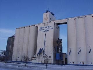
Northwood is a city in Grand Forks County, North Dakota, United States. It is part of the "Grand Forks, ND-MN Metropolitan Statistical Area" or "Greater Grand Forks." The population was 982 at the 2020 census.

Elgin is a city in Grant County, North Dakota, United States. The population was 543 at the 2020 census.

Cavour is a town in Beadle County, South Dakota, United States. The population was 128 at the 2020 census.

Wagner is a city in Charles Mix County, South Dakota, United States. The population was 1,490 at the 2020 census. The city is served by Wagner Municipal Airport as well as YST Transit buses.

Clear Lake is a city in and the county seat of Deuel County, South Dakota, United States. The population was 1,218 at the 2020 census.

Timber Lake is a city in and the county seat of Dewey County, South Dakota, United States. The population was 509 at the 2020 census.

Delmont is a city in southeastern Douglas County, South Dakota, United States. The population was 153 at the 2020 census.

Bowdle ( is a city in Edmunds County, South Dakota, United States. The population was 470 at the 2020 census.

Gregory is a city in western Gregory County, South Dakota, United States. The population was 1,221 at the 2020 census.

Castlewood is a city in Hamlin County, South Dakota, United States. It is part of the Watertown, South Dakota Micropolitan Statistical Area. The population was 698 at the 2020 census.

Parkston is a city in Hutchinson County, South Dakota, United States. The population was 1,567 at the 2020 census.

Wessington Springs is a town in central Jerauld County, South Dakota, United States. The population was 956 at the 2010 census. It is the county seat of Jerauld County.

Howard is a city in Miner County, South Dakota, United States. The population was 848 at the 2020 census. It is the county seat and most populous city in Miner County.

Crooks is a city in Minnehaha County, South Dakota, United States and is a suburb of Sioux Falls. The population was 1,362 at the 2020 census. Crooks was named New Hope until 1904. The town's present name honors W. A. Crooks, a local politician.

Hartford is a suburban American city in Minnehaha County, South Dakota, a few miles northwest of Sioux Falls. Its population was 3,354 at the 2020 census.

Woonsocket is a city in Sanborn County, South Dakota. The population was 631 at the 2020 census. It is the county seat of Sanborn County.

Centerville is a city in Turner County, South Dakota, United States. The population was 918 at the 2020 census. Centerville is part of the Sioux Falls, South Dakota metropolitan area.
This page is based on this
Wikipedia article Text is available under the
CC BY-SA 4.0 license; additional terms may apply.
Images, videos and audio are available under their respective licenses.