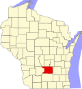
Springvale, Columbia County, Wisconsin

Last updated

Springvale, Wisconsin
WIMap-doton-Springvale.png
Location of Springvale, Wisconsin
Coordinates: 43°30′10″N89°11′23″W / 43.50278°N 89.18972°W / 43.50278; -89.18972
Country Flag of the United States.svg  United States
State Flag of Wisconsin.svg  Wisconsin
County Columbia
Area
  Total41.1 sq mi (106.3 km2)
  Land41 sq mi (106.2 km2)
  Water0 sq mi (0.1 km2)
Elevation
[1]
879 ft (268 m)
Population
 (2000)
  Total550
  Density13.4/sq mi (5.2/km2)
Time zone UTC-6 (Central (CST))
  Summer (DST) UTC-5 (CDT)
FIPS code 55-76225 [2]
GNIS feature ID1584201 [1]

Springvale is a town in Columbia County, Wisconsin, United States. The population was 550 at the 2000 census.

Contents

Geography

According to the United States Census Bureau, the town has a total area of 41 square miles (106.3 km2), of which, 41 square miles (106.2 km2) is land and 0.1 square miles (0.1 km2) (0.12%) is water.

Demographics

As of the census [2] of 2000, there were 550 people, 197 households, and 159 families residing in the town. The population density was 13.4 people per square mile (5.2/km2). There were 207 housing units at an average density of 5 per square mile (1.9/km2). The racial makeup of the town was 97.45% White, 0.18% African American, 0.55% Native American, 0.18% Asian, and 1.64% from two or more races. Hispanic or Latino people of any race were 0.18% of the population.

There were 197 households, out of which 37.6% had children under the age of 18 living with them, 74.6% were married couples living together, 3% had a female householder with no husband present, and 18.8% were non-families. 15.7% of all households were made up of individuals, and 5.1% had someone living alone who was 65 years of age or older. The average household size was 2.79 and the average family size was 3.13.

In the town, the population was spread out, with 28.7% under the age of 18, 5.1% from 18 to 24, 28.9% from 25 to 44, 24.9% from 45 to 64, and 12.4% who were 65 years of age or older. The median age was 38 years. For every 100 females, there were 117.4 males. For every 100 females age 18 and over, there were 111.9 males.

The median income for a household in the town was $47,188, and the median income for a family was $50,667. Males had a median income of $29,792 versus $25,208 for females. The per capita income for the town was $19,536. About 1.3% of families and 2.1% of the population were below the poverty line, including none of those under the age of eighteen or sixty-five or over.

Notable people

Related Research Articles

<span class="mw-page-title-main">Altona, Indiana</span> Town in Indiana, United States

Altona is a town in Keyser Township, DeKalb County, Indiana, United States. The population was 197 at the 2010 census.

<span class="mw-page-title-main">Lizton, Indiana</span> Town in Indiana, United States

Lizton is a town in Union Township, Hendricks County, Indiana, United States. The population was 488 at the 2010 Census. It is one of the three towns that make up North West Hendricks School Corporation.

<span class="mw-page-title-main">Eagle Lake, Maine</span> Town in the state of Maine, United States

Eagle Lake is a town in Aroostook County, Maine, United States. The population was 772 at the 2020 census. The town was named by a body of troops heading from Bangor to the Aroostook War for the many eagles that they saw around the lake. A total of 49.0% of the population speaks French, reflecting a trend in Northeastern Maine.

Otis is a town in Hancock County, Maine, United States. The population was 673 at the 2020 census.

LaGrange is a town in Penobscot County, Maine, United States. The population was 635 at the 2020 census.

Cambridge is a town in Somerset County, Maine, United States. The population was 443 at the 2020 census.

<span class="mw-page-title-main">Springvale, Maine</span> Place in Maine, United States

Springvale is a village and former census-designated place in the city of Sanford in York County, Maine, United States. The population was 3,292 at the 2010 census. It is part of the Portland–South Portland–Biddeford, Maine metropolitan statistical area. The CDP was abolished when the town of Sanford reincorporated as a city.

<span class="mw-page-title-main">Springvale Township, Michigan</span> Civil township in Michigan, United States

Springvale Township is a civil township of Emmet County in the U.S. state of Michigan. The population was 2,146 at the 2020 census.

<span class="mw-page-title-main">Junior, West Virginia</span> Town in West Virginia, United States

Junior is a town in Barbour County, West Virginia, United States, situated along the Tygart Valley River. The population was 384 at the 2020 census.

<span class="mw-page-title-main">Camden-on-Gauley, West Virginia</span> Town in West Virginia, United States

Camden-on-Gauley is a town in Webster County, West Virginia, United States, along the Gauley River. The population was 126 at the 2020 census.

<span class="mw-page-title-main">Bayview, Wisconsin</span> Town in Wisconsin, United States

Bayview is a town in Bayfield County, Wisconsin, United States. The population was 487 at the 2010 census. The unincorporated community of Sioux is located in the town.

<span class="mw-page-title-main">Hendren, Wisconsin</span> Town in Wisconsin, United States

Hendren is a town in Clark County in the U.S. state of Wisconsin. The population was 499 at the 2010 census. The unincorporated communities of Tioga and Willard are located in the town.

<span class="mw-page-title-main">Marietta, Wisconsin</span> Town in Wisconsin, United States

Marietta is a town in Crawford County, Wisconsin, United States. The population was 510 at the 2000 census. The unincorporated community of Easter Rock is located in the town. The unincorporated community of Boydtown is located partially in the town.

<span class="mw-page-title-main">Perry, Wisconsin</span> Town in Wisconsin, United States

Perry is a town in Dane County, Wisconsin, United States. The population was 737 at the 2020 census. The unincorporated communities of Daleyville and Forward are located in the town.

<span class="mw-page-title-main">Springvale, Fond du Lac County, Wisconsin</span> Town in Wisconsin, United States

Springvale is a town in Fond du Lac County, Wisconsin, United States. The population was 727 at the 2000 census. The unincorporated community of Ladoga is located partially in the town.

<span class="mw-page-title-main">Spring Lake, Wisconsin</span> Town in Wisconsin, United States

Spring Lake is a town in Pierce County, Wisconsin, in the United States. As of the 2000 census, the town population was 550. The unincorporated communities of Hatchville and Olivet are located partially in the town.

<span class="mw-page-title-main">Burnside, Wisconsin</span> Town in Wisconsin, United States

Burnside is a town in Trempealeau County, Wisconsin, in the United States. As of the 2000 census, the population was 529. The ghost town of New City was located in the town. The town was named after civil war general Ambrose Burnside.

<span class="mw-page-title-main">Fairchild, Wisconsin</span> Village in Wisconsin, United States

Fairchild is a village in Eau Claire County, Wisconsin, United States. The population was 550 at the 2010 census. The village is located within the Town of Fairchild.

<span class="mw-page-title-main">Antigo (town), Wisconsin</span> Town in Wisconsin, United States

Antigo is a town in Langlade County, Wisconsin, United States. The population was 1,412 at the 2010 census. The town is bordered to the southwest by the city of Antigo, the Langlade county seat.

Almond is a town in Portage County, Wisconsin, United States. The population was 679 at the 2000 census. The unincorporated community of West Almond is located in the town.

References

  1. 1 2 "US Board on Geographic Names". United States Geological Survey. October 25, 2007. Retrieved January 31, 2008.
  2. 1 2 "U.S. Census website". United States Census Bureau . Retrieved January 31, 2008.