Staplecross

Last updated

Staplecross
B2165 through Staplecross (geograph 5506827).jpg
B2165 road at Staplecross
East Sussex UK location map.svg
Red pog.svg
Staplecross
Location within East Sussex
Area0.2525 km2 (0.0975 sq mi)
Population760 (2011 census)
  Density 3,010/km2 (7,800/sq mi)
OS grid reference TQ7812
  London 45 miles (72 km) NW
District
Shire county
Region
Country England
Sovereign state United Kingdom
Post town ROBERTSBRIDGE
Postcode district TN32
Dialling code 01580
Police Sussex
Fire East Sussex
Ambulance South East Coast
UK Parliament
List of places
UK
England
East Sussex
50°58′25″N0°32′10″E / 50.9735°N 0.536117°E / 50.9735; 0.536117 Coordinates: 50°58′25″N0°32′10″E / 50.9735°N 0.536117°E / 50.9735; 0.536117

Staplecross is a village in the civil parish of Ewhurst and the Rother district of East Sussex, England. Staplecross is the largest settlement in Ewhurst parish, and is on a southern ridge of the valley of the River Rother which flows through Bodiam at the north of Staplecross. [1] The village is in the High Weald Area of Outstanding Natural Beauty. [2] In 2011 it had a population of 760. [3]

Contents

Staplecross is 24 miles (40 km) east-northeast from the county town of Lewes, and 3 miles (5 km) east from the A21 road, which in East Sussex runs north to south from Flimwell to Hastings. It is on the B2165 road which runs from the Ewhurst parish village of Cripps Corner, 1,500 yards (1,400 m) to the south, to Beckley, 4 miles (6 km) to the east. While in Staplecross the B2165 locally becomes Northiam Road. The village is centred on the junction of Northiam Road, and Bodiam Road which runs to Bodiam Castle, 2 miles (3 km) to the north. [4] [5]

Community amenities and facilities include a village hall with the adjacent Staplecross Club, The Cross Inn public house, a Londis convenience store & post office (the only post office in the parish), a bowls club, and a playing field with a children's play area. On Bodiam Road is Staplecross Methodist Primary School, north from which is a park with tennis courts. At the east of the village is the small red brick parish church of St Mark's which includes a preschool playgroup. A war memorial is at the junction of Northiam Road and Bodiam road. [4] [5]

To the south, outside the village on the B1265 is a garden centre and a plant nursery, and at the east, a cattery. At 3 miles to the north-east, in Northiam, is the Lutyens house and gardens of Great Dixter. [4] [5] On the B2244, less than 1 mile north-west from the village, is the 5.5 acres (2.2 hectares) Stainsmoor Wood, managed by a charitable trust. [6]

Staplecross is connected by bus to Hastings, Bodiam and Hawkhurst (349), and Westfield, Northiam and Robertsbridge (381). [7] The closest railway station is at Bodiam, part of the heritage Kent and East Sussex Railway, 1.5 miles (2.4 km) to the north, linking to the town of Tenterden at the north-east. [2] The closest National Rail station is at Robertsbridge on the Hastings line, 3 miles to the west, linking to Tunbridge Wells and Hastings.

Landmarks

Within Staplecross, defined by East Sussex County Council's village entry road signs, are fifteen Grade II listed buildings and structures.

On Bodliam Road is 'Wrens Cottage' a two-storey, weatherboarded and hipped-roof cottage dating to the 18th century or earlier; [8] the early 19th-century two-storey 'School House'; [9] the two-storey 'Brewery House' of red brick with hipped roof from the early 18th century, also its adjacent outbuilding of red brick below, weatherboarding above, and hipped roof, coupled with a conical oast house with cowl and fantail, from the late 18th or early 19th century; [10] [11] 'The Old Mill', a red brick former mill building with 1815 datestone; [12] 'The Mill House', a two-storied and weatherboarded house from the early 19th century; [13] and three two-storey 18th-century cottages of white-painted brick and half-hipped roofs. [14] Behind the 18th-century cottages, and on Forge Lane, are the conjoined 'Forge House', probably 17th-century, and 'Forge Cottage', 18th-century. Both are of a brick wall ground floor with overlapping red tile facing above, the House also with a hipped roof. [15]

Solomon's Garden cottage Solomons Garden (geograph 4465227).jpg
Solomon's Garden cottage

At the junction of Northiam Road, Bodiam Road and Forge Lane, is Staplecross War Memorial to the memory of those killed in the First and Second World Wars; unveiled in 1921, it is 9 feet (3 m) high, of Portland stone, and surmounted by a reclining lion. [16] Opposite is the 'Cross Inn', the northern part of which is listed, being two-storey and L-shaped of two wings. the 18th-century north wing is of red brick below with overlapping red tile facing above, the 19th-century west wing completely red brick. [17] South from the war memorial junction on the west side of Northiam Road are three listed cottages. The first, adjacent to and north from the Londis store are the conjoined two-storey 'Manor Cottage' and 'Stratfield Cottage' dating to at least the 18th century, of red brick below with overlapping red tile facing above. [18] The second, adjacent to and south from the Londis store, is the early 19th-century two-storey 'Edgell Cottage', of three bays and weatherboarded, with sash windows, a hipped slate roof and a gabled central porch. [19] The third, in the second plot down from Edgell Cottage and just inside the village, is the 15-century two-storey 'Solomon's Garden', timber-framed with infill of plaster set on a ground floor red brick plinth; the roof is thatched and hipped. [20]

At the east from the war memorial on the north side of Northiam Road is a terraced range of four listed early 19th-century two-storey cottages, the brick ground floor, and weatherboarding above, painted white. The back of the range is of eight gables. [21] Adjacent and detached to the east is the early 19th-century 'South View', similar in style and of two bays, weatherboarded, and white painted. [22] Further east, beyond Staplecross village hall, and opposite Cricketers Field (road), is 'Marigolds', a two-storey three-bay house dating to the 18th century. Its ground floor is stuccoed and painted white, and with a central wood trellis porch, with overlapping red tile facing above. [23] Further east again are 'Bowling Alley Cottages' opposite the village bowling green. The building was a conjoined range of three cottages, today two, and dates to the 18th century. The range has gabled porches, and is of two-storeys in painted brick, with a hipped roof and first floor of overlapping red tile facing on the west-most cottage. [24]

Related Research Articles

Great Budworth Human settlement in England

Great Budworth is a village and civil parish in Cheshire, England, four miles (6.4 km) north of Northwich off the A559 road, east of Comberbach, northwest of Higher Marston and southeast of Budworth Heath. Until 1948, Great Budworth was part of the Arley Hall estate.

Little Missenden Human settlement in England

Little Missenden is a village and civil parish on the River Misbourne in Buckinghamshire, England. It is in the Chiltern Hills, about 3 miles (5 km) southeast of Great Missenden and 3 miles (5 km) west of Amersham. The village lies on the River Misbourne in the Misbourne valley.

Chirton Human settlement in England

Chirton is a village and civil parish in Wiltshire, England, on the southern edge of the Vale of Pewsey about 5 miles (8 km) south-east of Devizes. The parish includes the hamlet of Conock, about half a mile west of Chirton village.

Weobley Village in Herefordshire, England

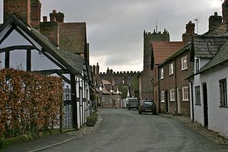
Weobley is an ancient settlement and civil parish in Herefordshire, England. Formerly a market town, the market is long defunct and the settlement is today promoted as one of the county's black and white villages owing to its abundance of old timber-framed buildings. Although it has the historical status of a town and is referred to as such in the sources, it nowadays refers to itself as a village.

Ewhurst, East Sussex Parish in East Sussex, England

Ewhurst is a civil parish in the Rother district of East Sussex, England. The parish is on the southern ridge of the River Rother valley, and much of the northern boundary of the parish follows the river. The centre of the parish is 24 miles (40 km) east-northeast from the county town of Lewes, and 9 miles (14 km) north from the coastal town of Hastings.

Northiam Human settlement in England

Northiam is a village and civil parish in the Rother district, in East Sussex, England, 13 miles (21 km) north of Hastings in the valley of the River Rother. The A28 road to Canterbury and Hastings passes through it.

Warnham Human settlement in England

Warnham is a village and civil parish in the Horsham district of West Sussex, England. The village is centred 2 miles (3.2 km) north-northwest of Horsham, 31 miles (50 km) from London, to the west of the A24 road. Other named settlements within the parish include the hamlets of Goosegreen, Kingsfold and Winterfold as well as parts of Strood Green and Rowhook. The area is in the northwest of the Weald, a gently sloped remnant forest in southeast England and largely a plain by erosion.

Battlesbridge Human settlement in England

Battlesbridge is a village in Essex, England. It straddles the River Crouch which is tidal and navigable up to this point. It is approximately 14 miles (23 km) south-southeast of Chelmsford and 4 miles (6.4 km) north of Rayleigh. The north bank of the river is in the civil parish of Rettendon, while the south bank is in Rawreth. It is a suburb of the town of Wickford and falls under the postal codes used in Wickford.

Blackstone, West Sussex Parish in West Sussex, England

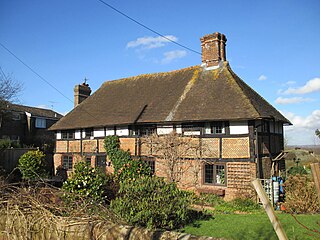
Blackstone is a hamlet in the civil parish of Woodmancote and the Horsham district of West Sussex, England. Blackstone is significant for its listed 17th- and 18th-century houses and cottages.
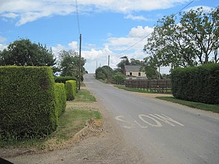
Southover General Baptist Chapel Church in East Sussex , United Kingdom

Southover General Baptist Chapel is a former Baptist place of worship in the ancient village of Southover, now part of the town and district of Lewes, one of six local government districts in the English county of East Sussex. Founded in 1741 as the first Baptist place of worship in the area, it attracted a congregation of General Baptists whose theological views gradually moved towards Unitarianism. This led to their union with the members of the nearby Westgate Chapel, after which the flint and brick building housed other congregations and secular groups before its conversion to a house. The building is protected as a Grade II by English Heritage.

Chilston Park Building in Boughton Malherbe, England

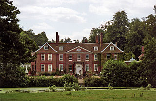
Chilston Park is a country house in Boughton Malherbe, Kent, England. Started in the 15th century, the house has been modified many times and is a Grade I listed building, currently operated as a country house hotel.
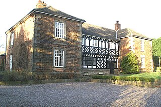
Housham Tye Human settlement in England

Housham Tye is a hamlet in the civil parish of Matching, and the Epping Forest district of Essex, England.

Knowl Green Human settlement in England

Knowl Green is a hamlet in the civil parish of Belchamp St Paul and the Braintree district of Essex, England.

Cripps Corner Village in East Sussex, England

Cripps Corner is a village in the civil parish of Ewhurst and the Rother district of East Sussex, England. It is in the High Weald Area of Outstanding Natural Beauty, and on a southern ridge of the valley of the River Rother which flows through Bodiam, 2.5 miles (4 km) to the north of Cripps Corner.

Risegate Village in the civil parish of Gosberton and the South Holland district of Lincolnshire, England

Risegate is a village in the civil parish of Gosberton and the South Holland district of Lincolnshire, England. It is 30 miles (50 km) south-east from the city and county town of Lincoln, 5 miles (8 km) north from the nearest large town of Spalding, and 2 miles (3 km) west-southwest from parish village of Gosberton.

Westhorpe, Lincolnshire Hamlet in the civil parish of Gosberton and the South Holland district of Lincolnshire, England

Westhorpe is a hamlet in the civil parish of Gosberton and the South Holland district of Lincolnshire, England. It is 30 miles (50 km) south-east from the city and county town of Lincoln, 6 miles (10 km) north from the nearest large town of Spalding, and 1 mile (1.6 km) west from parish village of Gosberton.

Todenham Human settlement in England

Todenham is a village and civil parish in the Cotswold district of Gloucestershire, England. The village is significant for its Grade I listed 14th-century parish church.

Pencombe with Grendon Warren Human settlement in England

Pencombe with Grendon Warren is a civil parish in the county of Herefordshire, England. The parish was created in 1895 from the parishes of Pencombe and Grendon Warren, its only nucleated settlement being the village of Pencombe.

Croft and Yarpole Parish in Herefordshire, England

Croft and Yarpole is a civil parish in the county of Herefordshire, England, and is 17 miles (27 km) north from the city and county town of Hereford. The closest large town is the market town of Leominster, 4.5 miles (7 km) to the south. Within the parish is the National Trust property of Croft Castle and Parkland.

Norton, Herefordshire Human settlement in England

Norton is a civil parish in north-east Herefordshire, England, and is approximately 14 miles (23 km) north-east from the city and county town of Hereford. The closest town is Bromyard, conjoined to the parish at the south-west. The parish includes the elevated public open common land of Bromyard Downs.

References

  1. "Staplecross" Archived 3 February 2019 at the Wayback Machine in Other Villages with Development Boundaries in the 2006 Local Plan, Rother District Council (2016). Retrieved 2 February 2019
  2. 1 2 "About Ewhurst" Archived 7 April 2016 at the Wayback Machine The Parish of Ewhurst (Parish Council). Retrieved 2 February 2019
  3. UK Census (2011). "Local Area Report – Staplecross BUA Built-up area sub division (1119883624)". Nomis. Office for National Statistics . Retrieved 3 February 2019.
  4. 1 2 3 Extracted from "GetOutside" Archived 2 February 2019 at the Wayback Machine , Staplecross, Ordnance Survey. Retrieved 2 February 2019
  5. 1 2 3 "Staplecross" Archived 3 February 2019 at the Wayback Machine , Grid Reference Finder. Retrieved 2 February 2019
  6. Staplecross Archived 8 April 2016 at the Wayback Machine , Olgar Trust. Retrieved 20 September 2019
  7. "Staplecross" Archived 3 February 2019 at the Wayback Machine , Bus Times. Retrieved 2 February 2019
  8. Historic England. "Wrens Cottage (1276411)". National Heritage List for England . Retrieved 2 February 2019.
  9. Historic England. "School House school Terrace (1233621)". National Heritage List for England. Retrieved 2 February 2019.
  10. Historic England. "Brewery House (1233808)". National Heritage List for England. Retrieved 2 February 2019.
  11. Historic England. "Outbuilding Adjoining Brewery House on the North East (1233619)". National Heritage List for England. Retrieved 2 February 2019.
  12. Historic England. "The Old Mill (1233810)". National Heritage List for England. Retrieved 2 February 2019.
  13. Historic England. "The Mill House (1233620)". National Heritage List for England. Retrieved 2 February 2019.
  14. Historic England. "Kent Cottage the Old Bakery the Polhills (1276511)". National Heritage List for England. Retrieved 2 February 2019.
  15. Historic England. "Forge Cottage Forge House (1233876)". National Heritage List for England. Retrieved 2 February 2019.
  16. Historic England. "Staplecross War Memorial (1436259)". National Heritage List for England. Retrieved 2 February 2019.
  17. Historic England. "The Cross Inn (1233926)". National Heritage List for England. Retrieved 2 February 2019.
  18. Historic England. "Manor Cottage, Stratfield Cottage (1276397)". National Heritage List for England. Retrieved 2 February 2019.
  19. Historic England. "Edgell Cottage (1276353)". National Heritage List for England. Retrieved 2 February 2019.
  20. Historic England. "Solomon's Garden (1233858)". National Heritage List for England. Retrieved 2 February 2019.
  21. Historic England. "Post Office Cottage staplecross Post Office and the Cottage Attached the Premises Occupied by Precision Optics wheelwrights (1276409)". National Heritage List for England. Retrieved 2 February 2019.
  22. Historic England. "South View (1233852)". National Heritage List for England. Retrieved 2 February 2019.
  23. Historic England. "Marigolds (1233891)". National Heritage List for England. Retrieved 2 February 2019.
  24. Historic England. "Bowling Alley Cottages (1276394)". National Heritage List for England. Retrieved 2 February 2019.