
The Toronto subway is a rapid transit system serving Toronto and the neighbouring city of Vaughan in Ontario, Canada, operated by the Toronto Transit Commission (TTC). As of September 2023, the subway system is a rail network consisting of three heavy-capacity rail lines operating predominantly underground. As of December 2022, three new lines are under construction: two light rail lines and one light metro line.

Eglinton West is a subway station on Line 1 Yonge–University in Toronto, Ontario, Canada. It is located in the median of Allen Road on the north side of Eglinton Avenue West.

Eglinton is a subway station on Line 1 Yonge–University of the Toronto subway. Located on Eglinton Avenue, it is central to the Yonge–Eglinton neighbourhood in Midtown Toronto. Eglinton station is the seventh busiest station of the Toronto Transit Commission (TTC).
The Eglinton West line was a proposed east–west subway line in Toronto, Ontario, Canada, whose construction began in 1994 but was cancelled in 1995. It was to start from the existing Eglinton West station on the Toronto Transit Commission's Yonge–University–Spadina line, travel underneath Eglinton Avenue West, and terminate at Black Creek Drive in its initial phase.
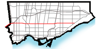
Eglinton Avenue is a major east–west arterial thoroughfare in Toronto and Mississauga in the Canadian province of Ontario. The street begins at Highway 407 at the western limits of Mississauga, as a continuation of Lower Baseline in Milton. It traverses the midsection of both cities and ends at Kingston Road. Eglinton Avenue is the only street to cross all six former cities and boroughs of Metropolitan Toronto.

Transit City was a plan for developing public transport in Toronto, Ontario, Canada. It was first proposed and announced on 16 March 2007 by Toronto mayor David Miller and Toronto Transit Commission (TTC) chair Adam Giambrone. The plan called for the construction of seven new light rail lines along the streets of seven priority transit corridors, which would have eventually been integrated with existing rapid transit, streetcar, and bus routes. Other transit improvements outlined in the plan included upgrading and extending the Scarborough RT line, implementing new bus rapid transit lines, and improving frequency and timing of 21 key bus routes. The plan integrated public transportation objectives outlined in the City of Toronto Official Plan, the TTC Ridership Growth Strategy and Miller's 2006 election platform.

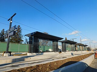
Line 5 Eglinton is a light rail line that is under construction in Toronto, Ontario, Canada. Owned by Metrolinx and operated by the Toronto Transit Commission (TTC), the line will be part of the Toronto subway system as its fifth route. The first phase of the 19-kilometre (12 mi) line will include 25 stops along Eglinton Avenue, from Mount Dennis station mostly underground to Laird station, after which it will run predominantly at-grade within the street's median to Kennedy station, where it will connect underground with Line 2 Bloor–Danforth. The second phase, a 9.2-kilometre (5.7 mi) westward extension from Mount Dennis, will run mostly underground or elevated to Renforth station, with seven new stations.
The Don Mills LRT was a proposed light rail line in Toronto, Ontario, Canada. It was part of the Transit City proposal announced March 16, 2007, to be operated by the Toronto Transit Commission (TTC). It was expected to cost approximately $675 million, with construction to begin in 2012, and an expected opening in 2016. It would have been the fifth of the seven Transit City lines to be complete after the Sheppard East, Finch West, Waterfront West, and Eglinton lines. Ridership was estimated to be 21.2 million trips in 2021.
The Sheppard East LRT was a proposed light rail line in Toronto, Ontario, Canada. It was first announced as part of the Transit City proposal in 2007. The Sheppard East LRT as proposed was to be 13 kilometres (8.1 mi) long, travel along Sheppard Avenue from Don Mills subway station to east of Morningside Avenue, and be operated by the Toronto Transit Commission (TTC).
The Eglinton East LRT (EELRT), also known as Line 7 Eglinton East and formerly known as the Scarborough Malvern LRT, is a proposed light rail line in Toronto, Ontario, Canada. The line would be entirely within the district of Scarborough. It was originally part of Transit City, a plan to develop new light rail lines along several priority transit corridors in the city.
Line 6 Finch West, also known as the Finch West LRT, is a light rail line under construction in Toronto, Ontario, Canada, to be operated by the Toronto Transit Commission. The 10.3-kilometre (6.4 mi), 18-stop line is to extend from Finch West station on Line 1 Yonge–University to the North Campus of Humber College in Etobicoke. The line will operate in a dedicated above-ground right-of-way, much of it within Finch Avenue, segregated from street traffic. The line will use transit signal priority and standard gauge rather than the broad Toronto gauge. The line is forecast to carry about 14.6 million rides a year or 40,000 a day by 2031 and will replace the 36B Finch West bus route, which is one of the three busiest bus routes in Toronto. Line 6 was expected to open within the first half of 2024, with an estimated cost of CA$2.5 billion. For budget purposes, the TTC made the assumption that Line 6 would open no earlier than September 2024. However, the builder, Mosaic Transit Group, expects the line to open by the end of 2024.
Mount Dennis is an intermodal transit terminal under construction in Toronto, Ontario, Canada. Located east of the intersection of Eglinton Avenue and Weston Road in the Mount Dennis neighbourhood in the district of York, the station will be the western terminus of the future Line 5 Eglinton as well as an intermediate station on the GO Transit Kitchener line and Union Pearson Express. The station has been designated as one of many "mobility hubs" in Greater Toronto. It is scheduled to open in 2024.

Fairbank is an underground light rail transit (LRT) station under construction on Line 5 Eglinton, a new line that is part of the Toronto subway system. It will be located in the Fairbank neighbourhood at the intersection of Dufferin Street and Eglinton Avenue West. Destinations include the Fairbank neighbourhood and Fairbank Memorial Park. As of 2017, construction work related to the station was in progress, having been scheduled to begin in 2014. The station is scheduled to open in 2024.

Forest Hill is an underground light rail transit (LRT) station under construction on Line 5 Eglinton, a new line that is part of the Toronto subway system. It will be located in the Forest Hill neighbourhood at the intersection of Bathurst Street and Eglinton Avenue. It is scheduled to open no earlier than 2024.

Avenue is an underground light rail transit (LRT) station under construction on Line 5 Eglinton, a new line that is part of the Toronto subway system. The station is located in North Toronto on Eglinton Avenue between Avenue Road and Highbourne Road. It is the deepest underground station on the line. Destinations include the Chaplin Estates neighbourhood, Marshall McLuhan Catholic Secondary School, the Eglinton Theatre, and Eglinton Park. The station is scheduled to open in 2024.

Leaside is an underground light rail transit (LRT) station under construction on Line 5 Eglinton, a new line that is part of the Toronto subway system. It is located in the Leaside neighbourhood at the intersection of Bayview Avenue and Eglinton Avenue. It is scheduled to open in 2024.

Laird is an underground light rail transit (LRT) station under construction on Line 5 Eglinton, a new line that is part of the Toronto subway system. It is located in the Leaside neighbourhood in East York at the intersection of Laird Drive and Eglinton Avenue. It is scheduled to open in 2024.

Science Centre is an underground light rail transit (LRT) station and mobility hub under construction on Line 5 Eglinton, a new line that is part of the Toronto subway system. It will be located in the Flemingdon Park neighbourhood at the intersection of Don Mills Road and Eglinton Avenue. It is scheduled to open in 2024.

Renforth, referred to during planning as Renforth Gateway, is a bus station on the border of the cities of Mississauga and Toronto, in Ontario, Canada. Located at Eglinton Avenue and Renforth Drive, it is the eastern terminus of the Mississauga Transitway and is close to the interchange between Highway 401 and Highway 427.
