Tatum, New Mexico

Last updated

Tatum, New Mexico
Tatum New Mexico Community Library.jpg
Tatum Community Library, May 2009
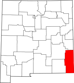
Lea County New Mexico Incorporated and Unincorporated areas Tatum Highlighted.svg
Location of Tatum in Lea County
USA New Mexico location map.svg
Red pog.svg
Tatum, New Mexico
Locations of Tatum in New Mexico
Usa edcp location map.svg
Red pog.svg
Tatum, New Mexico
Location in the United States
Coordinates: 33°15′19″N103°18′40″W / 33.25528°N 103.31111°W / 33.25528; -103.31111
Country United States
State New Mexico
County Lea
Area
[1]
  Total1.59 sq mi (4.12 km2)
  Land1.58 sq mi (4.11 km2)
  Water0.01 sq mi (0.02 km2)
Elevation
[2]
3,996 ft (1,218 m)
Population
 (2020) [3]
  Total706
  Density445.43/sq mi (171.96/km2)
Time zone UTC-7 (Mountain (MST))
  Summer (DST) UTC-6 (MDT)
ZIP codes
88213, 88267
Area code 575
FIPS code 35-76620
GNIS feature ID2413367 [2]
Website townoftatum.org

Tatum is a town in Lea County, New Mexico, United States. [2] The population was 798 at the 2010 census, [4] up from 683 in 2000.

Contents

Geography

Tatum is located in northern Lea County. U.S. Route 380 passes through the town, leading west 72 miles (116 km) to Roswell and east 30 miles (48 km) to Plains, Texas. New Mexico State Road 206 crosses US 380 in the center of Tatum, leading north 65 miles (105 km) to Portales and south 22 miles (35 km) to Lovington, the Lea county seat.

According to the United States Census Bureau, Tatum has a total area of 1.6 square miles (4.1 km2), of which 0.01 square miles (0.02 km2), or 0.47%, are water. [5]

Climate

According to the Köppen Climate Classification system, Tatum has a cold semi-arid climate, abbreviated "BSk" on climate maps. The hottest temperature recorded in Tatum was 115 °F (46.1 °C) on June 28, 1994, while the coldest temperature recorded was −16 °F (−26.7 °C) on January 11, 1962 and January 13, 1963. [6]

Climate data for Tatum, New Mexico, 1991–2020 normals, extremes 1919–2016
MonthJanFebMarAprMayJunJulAugSepOctNovDecYear
Record high °F (°C)82
(28)
86
(30)
92
(33)
97
(36)
107
(42)
115
(46)
110
(43)
107
(42)
105
(41)
98
(37)
86
(30)
82
(28)
115
(46)
Mean maximum °F (°C)72.7
(22.6)
76.9
(24.9)
83.2
(28.4)
89.0
(31.7)
96.3
(35.7)
101.4
(38.6)
100.7
(38.2)
98.9
(37.2)
95.3
(35.2)
88.6
(31.4)
80.1
(26.7)
73.0
(22.8)
103.9
(39.9)
Average high °F (°C)54.7
(12.6)
59.5
(15.3)
66.9
(19.4)
75.2
(24.0)
83.5
(28.6)
92.2
(33.4)
92.5
(33.6)
91.7
(33.2)
84.4
(29.1)
75.5
(24.2)
63.4
(17.4)
55.0
(12.8)
74.5
(23.6)
Daily mean °F (°C)39.0
(3.9)
43.1
(6.2)
49.8
(9.9)
57.5
(14.2)
66.9
(19.4)
76.0
(24.4)
78.1
(25.6)
77.0
(25.0)
69.7
(20.9)
59.4
(15.2)
47.3
(8.5)
39.7
(4.3)
58.6
(14.8)
Average low °F (°C)23.2
(−4.9)
26.7
(−2.9)
32.6
(0.3)
39.7
(4.3)
50.3
(10.2)
59.9
(15.5)
63.6
(17.6)
62.3
(16.8)
55.0
(12.8)
43.4
(6.3)
31.1
(−0.5)
24.5
(−4.2)
42.7
(5.9)
Mean minimum °F (°C)9.8
(−12.3)
12.0
(−11.1)
16.6
(−8.6)
26.1
(−3.3)
37.4
(3.0)
50.2
(10.1)
56.6
(13.7)
55.0
(12.8)
42.3
(5.7)
29.0
(−1.7)
16.6
(−8.6)
9.2
(−12.7)
5.2
(−14.9)
Record low °F (°C)−16
(−27)
−15
(−26)
−4
(−20)
10
(−12)
25
(−4)
33
(1)
42
(6)
42
(6)
28
(−2)
11
(−12)
0
(−18)
−8
(−22)
−16
(−27)
Average precipitation inches (mm)0.45
(11)
0.41
(10)
0.79
(20)
0.70
(18)
1.86
(47)
1.74
(44)
2.24
(57)
2.11
(54)
2.52
(64)
1.19
(30)
0.65
(17)
0.58
(15)
15.24
(387)
Average snowfall inches (cm)1.3
(3.3)
1.1
(2.8)
0.3
(0.76)
0.0
(0.0)
0.0
(0.0)
0.0
(0.0)
0.0
(0.0)
0.0
(0.0)
0.0
(0.0)
0.1
(0.25)
0.9
(2.3)
2.4
(6.1)
6.1
(15.51)
Average precipitation days (≥ 0.01 in)2.22.63.12.14.54.86.15.85.64.63.22.947.5
Average snowy days (≥ 0.1 in)1.11.20.30.10.00.00.00.00.00.10.61.34.7
Source 1: NOAA [7]
Source 2: National Weather Service (mean maxima/minima 19812010) [6]

Demographics

Historical population
CensusPop.Note
1950 688
1960 1,16869.8%
1970 982−15.9%
1980 896−8.8%
1990 768−14.3%
2000 683−11.1%
2010 79816.8%
2020 706−11.5%
U.S. Decennial Census [8] [3]

As of the census [9] of 2000, there were 683 people, 267 households, and 194 families residing in the town. The population density was 578.8 inhabitants per square mile (223.5/km2). There were 391 housing units at an average density of 331.3 per square mile (127.9/km2). The racial makeup of the town was 65.45% White, 1.02% African American, 0.59% Native American, 0.15% Pacific Islander, 30.31% from other races, and 2.49% from two or more races. Hispanic or Latino of any race were 37.34% of the population.

There were 267 households, out of which 31.5% had children under the age of 18 living with them, 61.0% were married couples living together, 7.9% had a female householder with no husband present, and 27.3% were non-families. 25.8% of all households were made up of individuals, and 12.4% had someone living alone who was 65 years of age or older. The average household size was 2.56 and the average family size was 3.08.

In the town, the population was spread out, with 28.1% under the age of 18, 6.9% from 18 to 24, 25.5% from 25 to 44, 23.7% from 45 to 64, and 15.8% who were 65 years of age or older. The median age was 38 years. For every 100 females, there were 96.8 males. For every 100 females age 18 and over, there were 95.6 males.

The median income for a household in the town was $28,833, and the median income for a family was $33,393. Males had a median income of $31,111 versus $19,750 for females. The per capita income for the town was $11,728. About 16.6% of families and 18.7% of the population were below the poverty line, including 21.8% of those under age 18 and 21.6% of those age 65 or over.

Transportation

Airport

Tatum Airport is a town-owned, public-use airport located three  nautical miles (6  km) east of the central business district of Tatum. [10]

Major roads

See also

Related Research Articles

<span class="mw-page-title-main">Lea County, New Mexico</span> County in New Mexico, United States

<span class="mw-page-title-main">Chaves County, New Mexico</span> County in New Mexico, United States

Chaves County is a county in New Mexico, United States. As of the 2020 census, the population was 65,157. Its county seat is Roswell. Chaves County was named for Colonel Jose Francisco Chaves, a military leader there during the Civil War and later in Navajo campaigns. The county was created by the New Mexico Territorial Legislature on February 25, 1889, out of land from Lincoln County.

<span class="mw-page-title-main">Kearny, Arizona</span> Town in Pinal County, Arizona

Kearny is a town in Pinal County, Arizona, United States. The town was named after General Stephen Watts Kearny, who passed through the area on November 7, 1846, while leading 100 dragoons to California. According to the 2010 census, the population of the town is 1,950. The economic base of Kearny and nearby towns is the Ray mine and Hayden Smelter, both owned and operated by ASARCO.

<span class="mw-page-title-main">Kaanapali, Hawaii</span> Census-designated place in Hawaii, United States

Kaanapali is a census-designated place (CDP) in Maui County, Hawaii, United States, on the island of Maui. The population was 1,161 at the 2020 census. The master-planned town is located in the Old Hawaii ahupuaa of Hanakaʻōʻō, as in the same name of the southern end of Kaanapali Beach's Hanakaʻōʻō Canoe Beach.

<span class="mw-page-title-main">Brookville, Indiana</span> Town in Indiana, United States

Brookville is a town in Brookville Township, Franklin County, Indiana, United States. The population was 2,596 at the 2010 census. The town is the county seat of and the largest community entirely within Franklin County.

<span class="mw-page-title-main">New Whiteland, Indiana</span> Town in Indiana, United States

New Whiteland is a town in Pleasant Township, Johnson County, Indiana, United States. The population was 5,550 at the 2020 census.

<span class="mw-page-title-main">Coldwater, Kansas</span> City in Comanche County, Kansas

Coldwater is a city and county seat of Comanche County, Kansas, United States. As of the 2020 census, the population of the city was 687.

<span class="mw-page-title-main">Hurley, New Mexico</span> Town in New Mexico, United States

Hurley is a town in Grant County, New Mexico, United States. The population was 1,297 at the 2010 census, down from 1,464 in 2000.

<span class="mw-page-title-main">Eunice, New Mexico</span> City in New Mexico, United States

Eunice is a city in Lea County, New Mexico, United States. The population was 2,922 at the 2010 census.

<span class="mw-page-title-main">Hobbs, New Mexico</span> City in New Mexico, United States

Hobbs is a city in Lea County, New Mexico, United States. Its population was 40,508 at the 2020 census, increasing from 34,122 in 2010.

<span class="mw-page-title-main">Jal, New Mexico</span> City in New Mexico, United States

Jal is a small city located in Lea County, New Mexico, United States. It is New Mexico's south-easternmost city, and shares a border with Texas to the east and south. The population was 2,047 at the 2010 census. Jal is historically important in the natural gas industry, from the early 1900s to the present day.

<span class="mw-page-title-main">Lovington, New Mexico</span> City in New Mexico, United States

Lovington is a city in, and the county seat of, Lea County, New Mexico, United States. The population was 11,009 at the 2010 census, up from 9,471 in 2000.

<span class="mw-page-title-main">McClusky, North Dakota</span> City in North Dakota, United States

McClusky is a city in Sheridan County, North Dakota, United States. It is the county seat of Sheridan County. The population was 322 at the 2020 census. McClusky was founded in 1905. It is the closest town to the geographical center of North Dakota, which lies approximately five miles to the southwest.

<span class="mw-page-title-main">Coolbaugh Township, Monroe County, Pennsylvania</span> Place in Pennsylvania, United States

Coolbaugh Township is a township in Monroe County, Pennsylvania, United States. The population was 20,805 at the 2020 census. Tobyhanna State Park is in Coolbaugh Township. Tobyhanna, an unincorporated community, is also located in Coolbaugh Township rather than Tobyhanna Township.

<span class="mw-page-title-main">Webster, South Dakota</span> City in South Dakota, United States

Webster is a city in and the county seat of Day County, South Dakota, United States. The population was 1,728 at the 2020 census.

<span class="mw-page-title-main">Rule, Texas</span> Town in Texas, United States

Rule is a town in Haskell County, Texas, United States. The population was 636 at the 2010 census, down from 698 at the 2000 census.

<span class="mw-page-title-main">La Crosse, Washington</span> Town in Washington, United States

La Crosse is a rural small town in Whitman County, Washington, United States. The population was 313 at the 2010 census.

<span class="mw-page-title-main">Wiley Ford, West Virginia</span> CDP in West Virginia, United States

Wiley Ford is a census-designated place (CDP) in Mineral County, West Virginia, United States and part of the 'Cumberland, MD-WV Metropolitan Statistical Area'. The population was 1,026 at the 2010 census.

<span class="mw-page-title-main">New Martinsville, West Virginia</span> City in West Virginia, United States

New Martinsville is a city in and the county seat of Wetzel County, West Virginia, United States, along the Ohio River. The population was 5,186 at the 2020 census.

<span class="mw-page-title-main">Tatum, Texas</span> City in Texas

Tatum is a city in Panola and Rusk counties in the U.S. state of Texas. The population was 1,342 at the 2020 census.

References

  1. "ArcGIS REST Services Directory". United States Census Bureau. Retrieved October 12, 2022.
  2. 1 2 3 U.S. Geological Survey Geographic Names Information System: Tatum, New Mexico
  3. 1 2 "Census Population API". United States Census Bureau. Retrieved October 12, 2022.
  4. "Total Population: 2010 Census DEC Summary File 1 (P1), Tatum town, New Mexico". data.census.gov. U.S. Census Bureau. Retrieved May 7, 2020.
  5. "U.S. Gazetteer Files: 2019: Places: New Mexico". U.S. Census Bureau Geography Division. Retrieved May 7, 2020.
  6. 1 2 "NOAA Online Weather Data – NWS Midland". National Weather Service. Retrieved April 8, 2023.
  7. "U.S. Climate Normals Quick Access – Station: Tatum, NM". National Oceanic and Atmospheric Administration. Retrieved April 8, 2023.
  8. "Census of Population and Housing". Census.gov. Retrieved June 4, 2015.
  9. "U.S. Census website". United States Census Bureau . Retrieved January 31, 2008.
  10. FAA Airport Form 5010 for 18T PDF . Federal Aviation Administration. Effective May 31, 2012.