Elamkulam is a village in Perinthalmanna taluk of Malappuram district in Kerala state.

Mankada is a hillside village in the Malappuram district of Kerala state. It is located 15 km (9.3 mi) from Malappuram and is part of the Malappuram parliament constituency. The municipal town of Perinthalmanna is just 10 km (6.2 mi) away. Also, the municipal towns of Manjeri and Malappuram are just 15 km (9.3 mi) away. Mankada Kadannamanna Kovilakam was the seat of ruling family of the erstwhile Kingdom of Valluvanad.
Pulamanthole is a Panchayath in Malappuram district of Kerala, India. It is situated on the banks of Kunthippuzha. The river separates Malappuram and Palakkad districts, a new bridge has been built across it recently.

Pattikkad is a town near Perinthalmanna, in Malappuram district of Kerala, in southwestern India. It is situated at about 5 km from Perinthalmanna, in the Valancheri- Perinthalmanna-Nilambur road. The railway station is on the Shoranur-Nilambur Railway Line. There are two Arabic colleges.

Vazhenkada is a village, known for its Kathakali heritage, on the banks of the river Thootha in Malappuram district of Kerala in southern India. The nearest small towns are Cherpulassery to its south 8 kilometres away and Perintalmanna to its north ,12 kilometres away.
Aliparamba is a village in Malappuram district in the state of Kerala, India.
Anamangad is a village in Malappuram district in the state of Kerala, India.
Arakkuparamba is a village in Malappuram district in the state of Kerala, India.

Edappatta is a village in Malappuram district in the state of Kerala, India.
Edayoor is an Indian village.

Keezhattur is a village in Malappuram district in the state of Kerala, India. Poonthanam illam, the birthplace of "bhakthakavi" Poonthanam namboothiri, famous ancient Malayalam poet, is located here. The poonthanam illam is now a popular cultural centre. Keezhattur is a moderately large panchayat.The major place in keezhattur panchayat is kizhattur.'kizhattur pooram' is the major festival in keezhattur. Its administrative offices are located in Akkaparambu, which is about 12 km away from Perinthalmanna, the largest city of Malappuram district.
Kuruvambalam is a village within the Perinthalmanna Taluk of Malappuram district in the state of Kerala, India.
Valambur is a town in Malappuram district in the state of Kerala, India.
Vettathur is a village in Malappuram district in the state of Kerala, India.
Angadipuram is a major suburb of Perinthalmanna town, in Malappuram District of Kerala, southern India. It was the capital of the powerful medieval kingdom of Valluvanad. Angadipuram is also known for Angadipuram Laterite, a notified go-heritage monument. Angadipuram is famous for its two temples, the Thirumandhamkunnu Temple and the Tali Mahadeva Temple. Kozhikode - Palakkad National Highway 966 passes through the town and Angadipuram Railway Station is one of the major railway station on the Nilambur - Shornur Line of Palakkad Division, Southern Railways. It is connected to major cities Kochi and Thiruvananthapuram through this line.
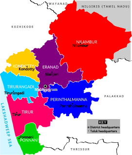
Perinthalmanna Taluk, formerly known as Walluvanad Taluk, comes under Perinthalmanna revenue division in Malappuram district of Kerala, India. Its headquarters is the town of Perinthalmanna. Perinthalmanna Taluk contains Perinthalmanna Municipality and 15 Gram panchayats. Most of the administrative offices are located in the Mini-Civil Station at Perinthalmanna.
Paravakkal is a town in the Kadungapuram village of the Puzhakkattiri panchayath, located in the Malappuram district, in the state of Kerala, southeast India. It was the homeland of Valluvanad, an erstwhile kingdom in Malabar. Perinthalmanna, Malappuram, and Kottakkal are some of the major towns nearby.
Perinthalmanna is a major town and municipality in Malappuram district, Kerala, India. It serves as the headquarters of the Perinthalmanna taluk, as well as of a block and a Revenue Division by the same name. It was formerly the headquarters of Valluvanad Taluk, which was one of the two Taluks in Malappuram Revenue Division of the erstwhile Malabar District during the British Raj. The town is located 23 kilometres (14 mi) south-west to the city of Malappuram at the centre of the Kozhikode-Malappuram-Perinthalmanna- Palakkad National Highway 966.
Pang is a village in Malappuram district in the state of Kerala, India.
Porur is a small village in Malappuram district, Kerala, India. Manjeri also is a nearby town.

