Thompsons Road, Melbourne

Last updated

Thompson Road

Also known as McLeod Road and Thompsons Road

Thompsons Road and Dandenong-Frankston Road, Carrum Downs.png
Thompsons Road and Dandenong-Frankston Road, Carrum Downs
Australia Victoria metropolitan Melbourne location map.svg
Red pog.svg
West end
Red pog.svg
East end
Coordinates
General information
Type Road
Length19 km (12 mi) [1]
Route number(s) Australian state route 6.svg State Route 6 (1989-present)
Major junctions
West endAustralian state route 3.svg Nepean Highway
Carrum, Melbourne
 
East endAUS Alphanumeric Route C407.svgBerwick–Cranbourne Road
Clyde North, Melbourne
Location(s)
Major suburbs Patterson Lakes, Lyndhurst, Cranbourne North

Thompson Road (and its western section as McLeod Road, and its eastern section as Thompsons Road) is a major urban arterial road in the south-eastern suburbs of Melbourne, Victoria, Australia.

Contents

Route

The road starts as McLeod Road from its intersection with Nepean Highway at Carrum, immediately crossing under the Frankston railway line and heading east as a two-lane, single-carriageway road through Patterson Lakes; at the intersection with MacLeod Road and Schooner Bay Drive, the name changes to Thompson Road and continues east as a four-lane, single-carriageway road to cross over Mornington Peninsula Freeway, before widening into a four-lane, dual-carriageway road, crossing EastLink to meet Frankston-Dandenong Road at Carrum Downs. The name changes for the last time to Thompsons Road and continues east through Lyndhurst and Cranbourne, to terminate at Berwick-Cranbourne Road in Clyde North.

History

McLeod Road originally terminated at Wells Road 500m south to Thompson Road's current alignment over the Mornington Peninsula Freeway; Thompson Road also terminated at Wells Road 100m north of the current bridge. Both roads were connected along their current alignment due to the construction of its interchange with the freeway (and consequent subsuming of Wells Road into it) when it opened in 1980.

Thompson Road was signed as State Route 6 between Carrum and Clyde North in 1989.

The passing of the Road Management Act 2004 [2] granted the responsibility of overall management and development of Victoria's major arterial roads to VicRoads: in 2004, VicRoads re-declared Thompson Road (Arterial #5164) from Nepean Highway in Carrum to Berwick-Cranbourne Road in Clyde North; [3] this declaration formally includes today's McLeod Road and Thompsons Road, but signposts along these sections have kept their original names.

Duplication Projects

Thompsons Road duplication, Carrum Downs [4]

This is a $31 million state government-funded project to widen Thompsons Road in Carrum Downs. Works involve widening to provide two lanes in each direction from east of Mornington Peninsula Freeway to EastLink, and three lanes in each direction between EastLink and Dandenong-Frankston Road. Construction started in mid-2008. [5] The works are 4 km long.

Thompsons Road duplication, Cranbourne [6]

This is a $22 million state government-funded project to widen Thompsons Road in Cranbourne. Works involve widening the road to three lanes in each direction between Lesdon Avenue and Rosebank Drive and two lanes in each direction between Rosebank Drive and Narre Warren-Cranbourne Road. The works are 1.7 km long.

Major intersections

LGALocation [1] [3] km [1] miDestinationsNotes
Kingston Carrum 0.00.0Australian state route 3.svg Nepean Highway (State Route 3)  Frankston, Mornington, Mordialloc, City Western terminus of McLeod Road and State Route 6; traffic lights
0.20.12 Frankston railway line
0.60.37Station StreetTraffic lights
Patterson Lakes 2.21.4Gladesville Boulevard  Chelsea Heights Roundabout
KingstonGreater Dandenong boundary Patterson LakesBangholme boundary2.61.6AUS Alphanumeric Route M11.svg Mornington Peninsula Freeway (M11)  Frankston, Portsea, Springvale Diamond interchange
FrankstonGreater Dandenong boundary Carrum DownsBangholme boundary5.23.2Worsley Road  Keysborough Traffic lights
5.53.4AUS Alphanumeric Route M3 toll.svg Eastlink (M3)  Frankston, Ringwood, City Diamond interchange
Carrum DownsLyndhurst-Bangholme tripoint6.64.1Australian state route 9.svg Dandenong-Frankston Road (State Route 9)  Frankston, Dandenong Traffic lights
Carrum DownsLyndhurst-Sandhurst tripoint7.34.5McCormicks Road  Carrum Downs Traffic lights
Greater DandenongCaseyFrankston tripoint LyndhurstSkye-Cranbourne West tripoint10.66.6AUS Alphanumeric Route M780.svg Western Port Highway (M780)  Hastings, City Traffic lights
Casey Lyndhurst-Cranbourne West boundary12.27.6Evans Road  Lynbrook, Cranbourne West Traffic lights
Cranbourne-Cranbourne NorthCranbourne West tripoint12.88.0 Cranbourne railway line
Cranbourne-Cranbourne North boundary13.88.6AUS Alphanumeric Route M420.svg South Gippsland Highway (M420)  Dandenong, Cranbourne, Phillip Island Traffic lights
Cranbourne-Cranbourne NorthCranbourne East tripoint15.69.7AUS Alphanumeric Route C404.svg Narre Warren-Cranbourne Road (C404)  Narre Warren, Cranbourne Roundabout
Clyde North-Cranbourne North boundary19.011.8AUS Alphanumeric Route C407.svg Berwick-Cranbourne Road (C407)  Clyde, Berwick Eastern terminus of Thompsons Road and State Route 6; roundabout
1.000 mi = 1.609 km; 1.000 km = 0.621 mi
  •       Route transition

See also

Australia road sign W5-29.svg   Australian roadsportal

Related Research Articles

City of Frankston Local government area in Victoria, Australia

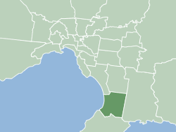
The City of Frankston is a local government area (LGA) in Victoria, Australia in the southern suburbs of Melbourne. It has an area of 130 square kilometres, and in June 2018, the City of Frankston recorded a population of 141,845.

Carrum Downs, Victoria Suburb of Melbourne, Victoria, Australia

Carrum Downs is a suburb of Melbourne, Victoria, Australia, 36 km south-east of Melbourne's Central Business District, located within the City of Frankston local government area. Carrum Downs recorded a population of 20,711 at the 2016 Census.

Langwarrin, Victoria Suburb of Melbourne, Victoria, Australia

Langwarrin is a suburb of Melbourne, Victoria, Australia, 42 km (26 mi) south-east from Melbourne's central business district. Its local government area is Frankston City. At the 2016 census, Langwarrin had a population of 22,588.

Cranbourne railway station

Cranbourne railway station is the terminus of the suburban electrified Cranbourne line in Victoria, Australia. It serves the south-eastern Melbourne suburb of Cranbourne, and it opened on 1 October 1888.

Nepean Highway

Nepean Highway runs south from St Kilda Junction in Victoria, Australia to Portsea, close to the eastern shore of Port Phillip. It is the primary road route to central Melbourne from Melbourne's southern suburbs.

South Gippsland Freeway

South Gippsland Freeway is a short freeway linking Dandenong in Melbourne's south-east to other south-eastern destinations, including the Mornington Peninsula and the Gippsland region. The freeway bears the designation M420.

Mornington Peninsula Freeway

Mornington Peninsula Freeway is a freeway in Melbourne, Victoria, Australia, that provides a link from outer suburban Melbourne to the Mornington Peninsula.

Frankston Freeway

In the city of Melbourne, the Frankston Freeway is a very short stretch of Melbourne freeway that was designed as an upgrade to the parallel Wells Road to freeway standard in the 1970s and provides a link from suburban Melbourne to Frankston. The freeway has previously been congested in holiday months due to a then-missing section of the Mornington Peninsula Freeway, which since the opening of Peninsula Link through traffic has reduced immensely on the Frankston Freeway.

Moorooduc Highway is a 16 km highway which runs from Frankston to Tuerong and, together with the Mornington Peninsula Freeway, was part of the main route from Melbourne to the Mornington Peninsula until the completion of Peninsula Link in 2013. This name is not widely known to most drivers, as the entire allocation is still best known as by the names of its constituent parts: McMahons Road, Frankston-Flinders Road, and Moorooduc Road. This article will deal with the entire length of the corridor for sake of completion, as well to avoid confusion between declarations.

Dandenong Valley Highway

The Dandenong Valley Highway is an urban highway stretching almost 40 kilometres from Bayswater in Melbourne's eastern suburbs to Frankston in the south. This name covers many consecutive streets and is not widely known to most drivers, as the entire allocation is still best known as by the names of its constituent parts: Stud Road, Foster Street, Dandenong-Frankston Road, Dandenong Road West and Fletcher Road. This article will deal with the entire length of the corridor for sake of completion, as well to avoid confusion between declarations.

Dingley Arterial Project

The Dingley Arterial Road Project is a partially completed arterial standard road which runs east to west through the southern suburbs of Melbourne, Australia.

Mornington Peninsula Nepean Football League

The Mornington Peninsula Nepean Football League is an Australian rules football competition, governed by the AFL South East. The MPNFL contains teams near the south eastern region of Melbourne, Victoria, Australia. At the end of the 2017 season, the competition was restructured from a geographical to a divisional structure, with promotion/ relegation. It contains two divisions with 22 teams in all, 10 in Division 1 and 12 in Division 2.

Western Port Highway is a highway in Victoria, Australia, linking the south-eastern fringe of suburban Melbourne to the western coast of Western Port Bay, after which the highway is named, at the Port of Hastings nearly 30 km to the south. It runs from the end of the South Gippsland Freeway at Lynbrook firstly as a dual carriageway and later as an undivided road to Frankston-Flinders Road at Hastings.

Warrigal Road

Warrigal Road is a major inner urban road in southeastern Melbourne, Australia. On weekdays, it is heavily trafficked as it runs through many major suburbs along its route, traversing some of Melbourne's eastern and south-eastern suburbs. These include suburbs Chadstone, Oakleigh, and Cheltenham. The Chadstone Shopping Centre can be accessed directly from Warrigal Road at its eastern entrance.

State Highway (Lower Dandenong/Cheltenham)

State Highway, also known as Lower Dandenong/Cheltenham State Highway, is an 12.5 km stretch of continuous road in the southeastern suburbs of Melbourne, Australia. These names are not widely known to most drivers, as the entire allocation is still best known as by the names of its constituent parts: Lower Dandenong Road, Cheltenham Road, and Foster Street. This article will deal with the entire length of the corridor for sake of completion, as well to avoid confusion between declarations.

State (Bell/Springvale) Highway

The State (Bell/Springvale) Highway, also known as Route 40 or the Bell/Springvale State Highway, is the longest self-contained urban highway in Melbourne, Australia, linking Tullamarine Freeway and Nepean Highway through Melbourne's north-eastern suburbs. These names are not widely known to most drivers, as the entire allocation is still best known as by the names of its constituent parts: Bell Street, Banksia Street, Manningham Road, Williamsons Road, Doncaster Road, Mitcham Road, Springvale Road and Edithvale Road. This article will deal with the entire length of the corridor for sake of completion, as well to avoid confusion between declarations.

City of Cranbourne Local government area in Victoria, Australia

The City of Cranbourne was a local government area about 45 kilometres (28 mi) southeast of Melbourne, the state capital of Victoria, Australia. The city covered an area of 755 square kilometres (291.5 sq mi), and existed from 1860 until 1994. It was notable for being the last local government area to be declared a city prior to the large-scale amalgamations of 1994 – its former designation was the Shire of Cranbourne.

Peninsula Link

Peninsula Link(Frankston Bypass) is a freeway that completes the missing sections of the Mornington Peninsula Freeway, running from the EastLink interchange at Seaford, Melbourne, running along the eastern fringe of Frankston. It runs via Baxter and Moorooduc, almost parallel to the existing arterial Moorooduc Highway. It was opened on 18 January 2013.

South Road is a major east-west arterial road in the south-eastern suburbs of Melbourne, Victoria, Australia.

References

  1. 1 2 3 Google (24 August 2021). "Thompson Road" (Map). Google Maps . Google. Retrieved 24 August 2021.
  2. State Government of Victoria. "Road Management Act 2004" (PDF). Government of Victoria. Archived (PDF) from the original on 19 October 2021. Retrieved 19 October 2021.
  3. 1 2 VicRoads. "VicRoads – Register of Public Roads (Part A) 2015" (PDF). Government of Victoria. pp. 279–81. Archived from the original on 1 May 2020. Retrieved 19 October 2021.
  4. VicRoads, "Archived copy". Archived from the original on 23 July 2008. Retrieved 1 March 2008.CS1 maint: archived copy as title (link)
  5. VicRoads, "Archived copy". Archived from the original on 22 September 2008. Retrieved 5 September 2008.CS1 maint: archived copy as title (link)
  6. VicRoads, http://www.vicroads.vic.gov.au/Home/RoadsAndProjects/RoadProjects/SouthEasternSuburbs/ThompsonRoadDuplicationCranbourne.htm Archived 23 July 2008 at the Wayback Machine