Tropical Storm Kujira (2015)

Last updated

Map key
  Tropical depression (≤38 mph, ≤62 km/h)
  Tropical storm (39–73 mph, 63–118 km/h)
  Category 1 (74–95 mph, 119–153 km/h)
  Category 2 (96–110 mph, 154–177 km/h)
  Category 3 (111–129 mph, 178–208 km/h)
  Category 4 (130–156 mph, 209–251 km/h)
  Category 5 (≥157 mph, ≥252 km/h)
  Unknown
Storm type
Disc Plain black.svg Tropical cyclone
Solid black.svg Subtropical cyclone
ArrowUp.svg Extratropical cyclone, remnant low, tropical disturbance, or monsoon depression

On June 15 at 20:00 UTC, the Joint Typhoon Warning Center (JTWC) began monitoring an area of convection that was located approximately 385 nautical miles (715 km; 445 mi) east-southeast of Huế, with the JTWC assessing the tropical cyclone development potential within the next day as low. The disorganized system was located within favorable conditions for development, with sea surface temperatures in the area ranging from 30–31 °C (86–88 °F). [2] The system began to organize, and on the next day at 06:00 UTC, the JTWC upgraded its development potential within the next day to medium. [3] At 18:00 UTC, the Japan Meteorological Agency (JMA) began issuing warnings on a tropical depression that had formed to the south of the Paracel Islands. [4] [5] [lower-alpha 1]

On June 20 at 03:00 UTC, the JTWC issued a Tropical Cyclone Formation Alert on the system. [7] Convection continued to deepen over the low-level circulation, and at 15:00 UTC, the JTWC upgraded the system to a tropical depression as it was located approximately 178 nautical miles (330 km; 205 mi) east-southeast of Da Nang, giving it the unofficial designation 08W. [8] On June 21 at 00:00 UTC, the JMA upgraded the depression to a tropical storm, assigning it the name Kujira. [9] The convection became sheared to the southwest of the low-level circulation, [10] and on June 22 at 03:00 UTC, the JTWC upgraded Kujira to a tropical storm. [11] At 12:00 UTC, Kujira peaked in intensity, with maximum sustained winds of 50 mph (85 km/h) and a minimum central pressure of 985  hPa (mbar; 29.09  inHg) as it made landfall on Hainan. [5] [lower-alpha 2] The JTWC briefly downgraded Kujira to a tropical depression as it entered the Gulf of Tonkin on June 23 at 03:00 UTC. [12] Kujira briefly re-intensified before making its final landfall on north Vietnam on June 24 at 03:40 UTC; [5] [1] the JTWC issued its final warning on Kujira at 03:00 UTC. [13] The JMA issued its final warning on Kujira at 18:00 UTC, [14] dissipating 12 hours later. [5]

Preparations and impact

Vietnam

22 thousand ships were notified of the presence of Kujira on June 21. [15] 31 thousand personnel and over 1 thousand vehicles were mobilized to assist in emergencies. [16] Flash floods killed 14 people, eight of which occurred in Sơn La Province, where rainfall of 280 millimetres (11 in) was recorded. [17] 15 people were injured and 382 houses were submerged, with another seventy being destroyed. 600 hectares of crops were inundated, and 12 bridges and several vehicles were swept away. Landslides throughout the areas affected cut off several sections of highways and roads. [18] In Cua Ong, a peak gust of 26 metres per second (94 km/h; 58 mph) was recorded, and on Bạch Long Vĩ Island, a station recorded a minimum pressure of 984.2 hPa (mbar; 29.06 inHg). [19] 219.9 millimetres (8.66 in) of rain was recorded from June 24–25, [20] with other areas near the coast experiencing heavy rains. [16] Total losses caused by Kujira were about 385 billion (US$17.6 million) throughout the country. [21] [22] [lower-alpha 3] [lower-alpha 4]

China

Rainfall from Kujira eased the worst drought in Hainan since 1959. [23] 40 thousand people were evacuated, and 162 flights were cancelled in Haikou Meilan International Airport and in Sanya Phoenix International Airport, which affected 11 thousand passengers. [24] Heavy rainfall and gale-force winds affected Hainan, with high-speed trains between Haikou and Sanya being suspended. [25] 40 thousand people were displaced and 20 thousand fishing boats returned to harbors, and elementary and middle schools in Haikou were suspended. [26] Hainan and Guangxi received between 250–392 millimetres (9.8–15.4 in) of rainfall. In Dongfang, Hainan, rainfall of 312 millimetres (12.3 in) was reported. [27] 159 thousand people were affected, and ¥85 million (US$13.69 million) in economic losses was incurred. [1]

Hong Kong

On June 21 at 13:40 UTC, a Signal No. 1 warning was issued for Hong Kong, before being cancelled on the next day at 23:40 UTC. A gust of 67 kilometres per hour (42 mph) was recorded on Waglan Island. HK$1,570 (US$202) in damages were recorded in Hong Kong. [28]

Elsewhere

Kujira enhanced the southwest monsoon in the Philippines, prompting the PAGASA to declare the beginning of the rainy season. [29] Fishermen were warned of gale conditions in the Andaman Sea and in the Gulf of Thailand. Northeast Thailand experienced precipitation. [30] Rainfall associated with Kujira brought flooding to parts of Myanmar. [31]

See also

Notes

  1. The Japan Meteorological Agency is the official Regional Specialized Meteorological Centre for the western Pacific Ocean. [6]
  2. All winds are in ten-minute sustained standards, as per the Japan Meteorological Agency, [5] unless otherwise stated.
  3. Currencies are converted to US Dollars using XE Currency Converter.
  4. All currencies are in their 2015 values unless otherwise noted.

Related Research Articles

<span class="mw-page-title-main">2009 Pacific typhoon season</span> Typhoon season in the Western Pacific Ocean

The 2009 Pacific typhoon season was a below average season that spawned only 22 named storms, 13 typhoons, and five super typhoons. It was also recognized as the deadliest season in the Philippines for decades. The first half of the season was very quiet whereas the second half of the season was extremely active. The season's first named storm, Kujira, developed on May 3 while the season's last named storm, Nida, dissipated on December 3.

<span class="mw-page-title-main">Timeline of the 2009 Pacific typhoon season</span>

This timeline documents all of the events of the 2009 Pacific typhoon season which was the period that tropical cyclones formed in the Western Pacific Ocean during 2009, with most of the tropical cyclones forming between May and November. The scope of this article is limited to the Pacific Ocean, north of the equator between 100°E and the International Date Line. Tropical storms that form in the entire Western Pacific basin are assigned a name by the Japan Meteorological Agency. Tropical depressions that form in this basin are given a number with a "W" suffix by the United States' Joint Typhoon Warning Center. In addition, the Philippine Atmospheric, Geophysical and Astronomical Services Administration (PAGASA) assigns names to tropical cyclones that enter or form in the Philippine area of responsibility. These names, however, are not in common use outside of the Philippines.

<span class="mw-page-title-main">2015 Pacific typhoon season</span> Typhoon season in the Western Pacific Ocean

The 2015 Pacific typhoon season was a slightly above average season that produced twenty-seven tropical storms, eighteen typhoons, and nine super typhoons. The season ran throughout 2015, though most tropical cyclones typically develop between May and November. The season's first named storm, Mekkhala, developed on January 15, while the season's last named storm, Melor, dissipated on December 17. The season saw at least one named tropical system forming in each of every month, the first time since 1965. Similar to the previous season, this season saw a high number of super typhoons. Accumulated cyclone energy (ACE) during 2015 was extremely high, the third highest since 1970, and the 2015 ACE has been attributed in part to anthropogenic warming.

<span class="mw-page-title-main">2017 Pacific typhoon season</span> Typhoon season in the Western Pacific Ocean

The 2017 Pacific typhoon season was a below-average season in terms of accumulated cyclone energy and the number of typhoons and super typhoons, and the first since the 1977 season to not produce a Category 5-equivalent typhoon on the Saffir–Simpson scale. The season produced a total of 27 named storms, 11 typhoons, and only two super typhoons, making it an average season in terms of storm numbers. It was an event in the annual cycle of tropical cyclone formation, in which tropical cyclones form in the western Pacific Ocean. The season runs throughout 2017, though most tropical cyclones typically develop between May and October. The season's first named storm, Muifa, developed on April 25, while the season's last named storm, Tembin, dissipated on December 26. This season also featured the latest occurrence of the first typhoon of the year since 1998, with Noru reaching this intensity on July 23.

<span class="mw-page-title-main">Timeline of the 2010 Pacific typhoon season</span>

This timeline documents all of the events of the 2010 Pacific typhoon season. Most of the tropical cyclones forming between May and November. The scope of this article is limited to the Pacific Ocean, north of the equator between 100°E and the International Date Line. Tropical storms that form in the entire Western Pacific basin are assigned a name by the Japan Meteorological Agency. Tropical depressions that form in this basin are given a number with a "W" suffix by the United States' Joint Typhoon Warning Center. In addition, the Philippine Atmospheric, Geophysical and Astronomical Services Administration (PAGASA) assigns names to tropical cyclones that enter or form in the Philippine area of responsibility. These names, however, are not in common use outside of the Philippines.

<span class="mw-page-title-main">Tropical Storm Khanun (2012)</span> Pacific severe tropical storm in 2012

Severe Tropical Storm Khanun, known in the Philippines as Tropical Storm Enteng, was the first tropical cyclone to directly impact Korea in two years. It is the 8th named storm, the 3rd severe tropical storm, and overall, the 13th tropical cyclone to be monitored by the Japan Meteorological Agency (JMA) during 2012. Khanun was also the first tropical storm to make a landfall over Korea in 2012. Khanun means "jack fruit" in Thai.

<span class="mw-page-title-main">2020 Pacific typhoon season</span> Typhoon season in the Western Pacific Ocean

The 2020 Pacific typhoon season was the first with below-average tropical cyclone activity since 2017, with 23 named storms, 10 of which became typhoons and only 2 became super typhoons. This low activity was a consequence of La Niña that persisted from the summer of the year. It had the fifth-latest start in the basin on record, slightly behind 1973, and was the first to start that late since 2016. The first half of the season was unusually inactive, with only four systems, two named storms and one typhoon at the end of July. Additionally, the JTWC recorded no tropical cyclone development in the month of July, the first such occurrence since reliable records began. The season's first named tropical cyclone, Vongfong, developed on May 8, while the season's last named tropical cyclone, Krovanh, dissipated on December 24. However, the season's last system was an unnamed tropical depression which dissipated on December 29.

<span class="mw-page-title-main">Timeline of the 2014 Pacific typhoon season</span>

This timeline documents all of the events of the 2014 Pacific typhoon season. Most of the tropical cyclones forming between May and November. The scope of this article is limited to the Pacific Ocean, north of the equator between 100°E and the International Date Line. Tropical storms that form in the entire Western Pacific basin are assigned a name by the Japan Meteorological Agency. Tropical depressions that form in this basin are given a number with a "W" suffix by the United States' Joint Typhoon Warning Center. In addition, the Philippine Atmospheric, Geophysical and Astronomical Services Administration (PAGASA) assigns names to tropical cyclones that enter or form in the Philippine area of responsibility. These names, however, are not in common use outside of the Philippines.

<span class="mw-page-title-main">Tropical Storm Lingling (2014)</span> Pacific tropical storm in 2014

Tropical Storm Lingling, known in the Philippines as Tropical Depression Agaton, was a weak but deadly tropical cyclone that affected the Philippines in January 2014. The first named storm of the annual typhoon season, this early-season cyclone remained very disorganized throughout its lifespan. Lingling was the first major natural disaster in the Philippines after Typhoon Haiyan just two months earlier, as it caused widespread landslide incidents and floods in Mindanao, resulting in 70 deaths and damage amounting to over 566 million pesos on the island.

<span class="mw-page-title-main">Timeline of the 2012 Pacific typhoon season</span>

This timeline documents all of the events of the 2012 Pacific typhoon season. The scope of this article is limited to the Pacific Ocean, north of the equator between 100°E and the International Date Line. During the season, 34 systems were designated as tropical depressions by either the Japan Meteorological Agency (JMA), the Philippine Atmospheric, Geophysical and Astronomical Services Administration (PAGASA), the Joint Typhoon Warning Center (JTWC), or other National Meteorological and Hydrological Services such as the China Meteorological Administration and the Hong Kong Observatory. Since the JMA runs the Regional Specialized Meteorological Centre (RSMC) for the Western Pacific, they assigned names to tropical depressions which developed into tropical storms in the basin. PAGASA also assigned local names to systems which are active in their area of responsibility; however, these names are not in common use outside of the Philippines.

<span class="mw-page-title-main">Timeline of the 2015 Pacific typhoon season</span>

This timeline documents all of the events of the 2015 Pacific typhoon season. Most of the tropical cyclones formed between May and November. The scope of this article is limited to the Pacific Ocean, north of the equator between 100°E and the International Date Line. This area, called the Western Pacific basin, is the responsibility of the Japanese Meteorological Agency (JMA). They host and operate the Regional Specialized Meteorological Center (RSMC), located in Tokyo. The Japanese Meteorological Agency (JMA) is also responsible for assigning names to all tropical storms that are formed within the basin. However, any storm that enters or forms in the Philippine Area of Responsibility (PAR) will be named by the Philippine Atmospheric, Geophysical and Astronomical Services Administration (PAGASA) using a local name. Also of note - the Western Pacific basin is monitored by the United States' Joint Typhoon Warning Center (JTWC), which gives all Tropical depressions a number with a "W" suffix.

<span class="mw-page-title-main">Tropical Storm Sonca (2017)</span> Pacific tropical storm in 2017

Tropical Storm Sonca was a weak tropical cyclone that impacted Indochina during the end of July 2017.

<span class="mw-page-title-main">2021 Pacific typhoon season</span> Typhoon season in the Western Pacific Ocean

The 2021 Pacific typhoon season was the second consecutive to have below-average tropical cyclone activity, with twenty-two named storms, and was the least active since 2011. Nine became typhoons, and five of those intensified into super typhoons. This low activity was caused by a strong La Niña that had persisted from the previous year. The season's first named storm, Dujuan, developed on February 16, while the last named storm, Rai, dissipated on December 21. The season's first typhoon, Surigae, reached typhoon status on April 16. It became the first super typhoon of the year on the next day, also becoming the strongest tropical cyclone in 2021. Surigae was also the most powerful tropical cyclone on record in the Northern Hemisphere for the month of April. Typhoons In-fa and Rai are responsible for more than half of the total damage this season, adding up to a combined total of $2.02 billion.

<span class="mw-page-title-main">2022 Pacific typhoon season</span> Typhoon season in the Western Pacific Ocean

The 2022 Pacific typhoon season was the third consecutive season to have below-average tropical cyclone activity, with twenty-five named storms forming. Of the tropical storms, ten became typhoons, and three would intensify into super typhoons. The season saw a slightly below average activity by named storm count, although many of the storms were weak and short-lived, particularly towards the end of the season. This low activity was caused by an unusually strong La Niña that had persisted from 2020. The season's first named storm, Malakas, developed on April 6, while the last named storm, Pakhar, dissipated on December 12. The season's first typhoon, Malakas, reached typhoon status on April 12. The season ran throughout 2022, though most tropical cyclones typically develop between May and October. Tropical storms Megi and Nalgae were responsible for more than half of the casualties, while typhoons Hinnamnor and Nanmadol both caused $1 billion in damages.

<span class="mw-page-title-main">Typhoon Saudel</span> Pacific typhoon in 2020

Typhoon Saudel, known in the Philippines as Typhoon Pepito, was a typhoon that affected the Philippines, Vietnam and Southern China in October 2020. It was seventeenth tropical storm and seventh typhoon of the 2020 Pacific typhoon season. The name Saudel was used for the first time, replacing Typhoon Soudelor in 2015, which caused serious damage in Taiwan and Mainland China. Saudel formed from a tropical disturbance east of the Philippines. The disturbance gradually organized and crossed the Philippines as a tropical storm. Once the system emerged into the South China Sea, it began to rapidly organize and intensify, becoming a typhoon early on October 22.

<span class="mw-page-title-main">Typhoon Soulik (2018)</span> Pacific typhoon in 2018

Typhoon Soulik was an unusually large, and the deadliest typhoon to strike the Korean Peninsula since Khanun in 2012. Soulik formed from an area of low pressure on August 15, and was the twenty-ninth tropical depression, twentieth tropical storm, tenth severe tropical storm, and sixth typhoon of the 2018 Pacific typhoon season.

<span class="mw-page-title-main">Tropical Storm Merbok (2017)</span> Pacific severe tropical storm in 2017

Severe Tropical Storm Merbok was a weak tropical cyclone that brought significant impacts to southern China in June 2017. Merbok developed out of a tropical depression which was first monitored by the JMA while it was west of Manila, Philippines, on June 10. The system would later be named 04W by the JTWC. The depression then strengthened into Tropical Storm Merbok before making landfall in eastern Shenzhen, China. Merbok would rapidly weaken inland, dissipating over Southern China on June 13.

<span class="mw-page-title-main">Typhoon Prapiroon (2018)</span> Pacific typhoon in 2018

Typhoon Prapiroon, known in the Philippines as Severe Tropical Storm Florita, was a Category 1 typhoon that worsened the floods in Japan and also caused impacts in neighboring South Korea. The storm formed from an area of low pressure near the Philippines, and strengthened to a typhoon before entering the Sea of Japan. Prapiroon was the seventh named tropical cyclone and the first typhoon of the annual annual typhoon season. While Florita was the sixth named tropical cyclone by PAGASA.

<span class="mw-page-title-main">Tropical Storm Durian (2001)</span> Pacific severe tropical storm in 2001

Severe Tropical Storm Durian was a deadly system that caused severe impacts in China and Vietnam. The seventh tropical depression and third named storm of the 2001 Pacific typhoon season, the storm was first noted on June 29 and quickly intensified into a tropical storm and given the name Durian by the Japan Meteorological Agency (JMA). Durian continued northwestward before intensifying into a severe tropical storm as it approached the Chinese coast. On July 1 just before landfall, Durian peaked in intensity, with the JMA estimating 10-min winds of 110 km/h (68 mph) and the Joint Typhoon Warning Center (JTWC) estimating 1-min winds of 140 km/h (87 mph). Durian made landfall on Zhanjiang at peak intensity, before quickly weakening over land and dissipating on July 3 over the mountains of Vietnam.

<span class="mw-page-title-main">Typhoon Cempaka</span> Pacific typhoon in 2021

Typhoon Cempaka was a moderately-strong and fairly long-lived tropical cyclone that caused substantial damage in China and Vietnam toward the end of July 2021. The seventh named storm and the fourth typhoon of the 2021 Pacific typhoon season, the storm formed from a tropical disturbance west of the Philippines on July 17. Around the same time, the JMA recognized the system as a tropical depression, with the JTWC issuing a TCFA for the disturbance. The storm slowly moved northwestward towards China, and on July 19, the system strengthened into a tropical storm and was given the name Cempaka by the JMA. On the next day, Cempaka reached its peak intensity, peaking as a Category 1-equivalent typhoon, before making landfall on China later that day. Afterward, Cempaka rapidly weakened as it moved inland, weakening into a tropical depression on July 21. The storm subsequently initiated a counterclockwise loop, moving westward across southern China, and turning southward and emerging into the Gulf of Tonkin on July 23. Afterward, Cempaka turned eastward for the next few days, before dissipating over southern Hainan on July 26.

References

  1. 1 2 3 "Member Report: China" (PDF). typhooncommittee.org. October 26–29, 2015. Retrieved April 24, 2021.
  2. "Significant Tropical Weather Advisory for the Western and South Pacific Oceans Reissued from 182000Z-190600Z June 2015". weather.noaa.gov. Joint Typhoon Warning Center. June 18, 2015. Archived from the original on June 30, 2015. Retrieved April 24, 2021.
  3. "Significant Tropical Weather Advisory for the Western and South Pacific Oceans from 190600Z-200600Z June 2015". weather.noaa.gov. Joint Typhoon Warning Center. June 19, 2015. Archived from the original on June 30, 2015. Retrieved April 24, 2021.
  4. "Warning and Summary 191800". weather.noaa.gov. Japan Meteorological Agency. June 19, 2015. Archived from the original on July 5, 2015. Retrieved April 24, 2021.
  5. 1 2 3 4 5 Annual Report on the Activities of the RSMC Tokyo – Typhoon Center 2015 (PDF) (Report). Japan Meteorological Agency. 2016. p. 83. Retrieved April 24, 2021.
  6. Annual Report on Activities of the RSMC Tokyo – Typhoon Center 2000 (PDF) (Report). Japan Meteorological Agency. February 2001. p. 3. Retrieved April 24, 2021.
  7. "WTPN21 PGTW 200300". weather.noaa.gov. Joint Typhoon Warning Center. June 20, 2015. Archived from the original on June 30, 2015. Retrieved April 24, 2021.
  8. "Prognostic Reasoning for Tropical Depression 08W (Eight) Warning NR 01". weather.noaa.gov. Joint Typhoon Warning Center. June 20, 2015. Archived from the original on June 26, 2015. Retrieved April 24, 2021.
  9. "RSMC Tropical Cyclone Advisory 210000". weather.noaa.gov. Japan Meteorological Agency. June 21, 2015. Archived from the original on June 30, 2015. Retrieved April 24, 2021.
  10. "Prognostic Reasoning for Tropical Depression 08W (Kujira) Warning NR 06". weather.noaa.gov. Joint Typhoon Warning Center. June 21, 2015. Archived from the original on June 26, 2015. Retrieved April 24, 2021.
  11. "Prognostic Reasoning for Tropical Storm 08W (Kujira) Warning NR 07". weather.noaa.gov. Joint Typhoon Warning Center. June 22, 2015. Archived from the original on June 26, 2015. Retrieved April 24, 2021.
  12. "Prognostic Reasoning for Tropical Depression 08W (Kujira) Warning NR 11". weather.noaa.gov. Joint Typhoon Warning Center. June 23, 2015. Archived from the original on June 26, 2015. Retrieved April 24, 2021.
  13. "Tropical Depression 08W (Kujira) Warning NR 015". weather.noaa.gov. Joint Typhoon Warning Center. June 24, 2015. Archived from the original on June 26, 2015. Retrieved April 24, 2021.
  14. "RSMC Tropical Cyclone Advisory 241800". weather.noaa.gov. Japan Meteorological Agency. June 24, 2015. Archived from the original on June 30, 2015. Retrieved April 24, 2021.
  15. "Vietnamese fishermen informed of storm Kujira". VietNamNet. June 22, 2015. Retrieved April 24, 2021.
  16. 1 2 "Typhoon Kujira set to make landfall today". Việt Nam News . June 24, 2015. Retrieved April 24, 2021.
  17. Blašković, Teo (June 26, 2015). "Typhoon "Kujira" brings deadly flash floods to Vietnam". The Watchers. Retrieved April 24, 2021.
  18. "Flash floods killed 9, leave 6 others missing in northern Vietnam". Tuoi Tre News. June 26, 2015. Archived from the original on September 25, 2020. Retrieved April 24, 2021.
  19. "Member Report: Socialist Republic of Vietnam" (PDF). typhooncommittee.org. October 2015. Retrieved April 24, 2021.
  20. Davies, Richard (June 26, 2015). "7 Dead, 4 Missing After Flash Floods in Son La Province, Vietnam". FloodList. Retrieved April 24, 2021.
  21. Report on natural disasters and hazards in 2016, VDMA
  22. "Ra đường tung lưới bắt cá sau bão số 1 ở Sơn La". VietNamNet (in Vietnamese). June 25, 2015. Retrieved April 24, 2021.
  23. Fan, Wang (June 22, 2015). "China issues alert over typhoon Kujira". China News Service . Retrieved April 24, 2021.
  24. Blašković, Teo (June 24, 2015). "Typhoon "Kujira" impacts southern China and Vietnam, brings heavy rain". The Watchers. Retrieved April 24, 2021.
  25. "Typhoon Kujira makes landfall in south China". China Daily . June 22, 2015. Retrieved April 24, 2021.
  26. "China hit by Typhoon Kujira: Facts to know". India Today . June 23, 2015. Retrieved April 24, 2021.
  27. Angwin, Richard (June 23, 2015). "Tropical Storm Kujira brings more floods to East Asia". Al Jazeera . Retrieved April 24, 2021.
  28. HKO Tropical Cyclones in 2015 (PDF) (Report). Kowloon: Hong Kong Observatory. September 2016. Retrieved April 24, 2021.
  29. "PAGASA: Start of rainy season to raise dam water levels, help irrigation". GMA News and Public Affairs . June 23, 2015. Retrieved April 24, 2021.
  30. "Tropical storm Kujira to continue to bring rain to Northeast of Thailand". Pattaya Mail. June 27, 2015. Retrieved April 24, 2021.
  31. Myint, Moe (June 26, 2015). "At Least One Dead as Southern Burma Lashed by Heavy Rains, Flooding". The Irrawaddy . Retrieved April 24, 2021.
Tropical Storm Kujira
Kujira Jun 22 2015 0605Z.jpg
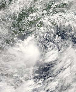
Tropical Storm Kujira at peak intensity on June 22