
Arbanasce, is a village in Serbia in the municipality Merošina in Nisava district. According to the census of 2002, there were 568 people.

Aleksinački Bujmir is a village in Serbia situated in the municipality of Aleksinac, in the Nišava District. The population of the village was 557 people at the 2002 census.

Brzózki is a village in the administrative district of Gmina Szubin, within Nakło County, Kuyavian-Pomeranian Voivodeship, in north-central Poland. It lies approximately 9 kilometres (6 mi) north of Szubin, 10 km (6 mi) south-east of Nakło nad Notecią, and 19 km (12 mi) west of Bydgoszcz.
Obrež is a village in Serbia. It is situated in the Varvarin municipality, in the Rasina District. The village has a Serb ethnic majority and its population numbering 3,879 people.
Starci is a village in the municipality of Aleksandrovac, Serbia. According to the 2002 census, the village has a population of 53 people.
Vražogrnci is a village in the municipality of Aleksandrovac, Serbia. According to the 2002 census, the village has a population of 297 people.
Bradarac is a village in the municipality of Aleksinac, Serbia. According to the 2002 census, the village has a population of 334 people.
Dašnica is a village in the municipality of Aleksinac, Serbia. According to the 2002 census, the village has a population of 115 people.
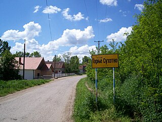
Gornje Suhotno is a village in the municipality of Aleksinac, Serbia. According to the 2002 census, the village has a population of 343 people.
Grejač is a village in the municipality of Aleksinac, Serbia. According to the 2002 census, the village has a population of 696 people.
Mozgovo is a village in the municipality of Aleksinac, Serbia. According to the 2002 census, the village has a population of 1632 people. It is situated in Srbija, Serbia and Montenegro. Geographical coordinates are 43° 39' 25" North, 21° 39' 49" East. Its original name is Mozgovo.
Vakup is a village in the municipality of Aleksinac, Serbia. According to the 2002 census, the village has a population of 740 people.
Šatra is a village in the municipality of Kuršumlija, Serbia. According to the 2002 census, the village has a population of 33 people.
Maskare is a village in the municipality of Varvarin, Serbia. According to the 2002 census, the village has a population of 539 people.
Gradište is a village in Serbia in the municipality Merošina in Nisava district. According to the census of 2002, there were 596 people. In the near Gradiste, is the archeological site Kulina.
Međani is a village in the municipality of Prijepolje, Serbia. According to the 2002 census, the village has a population of 80 people.
Staro Selo is a small town in the municipality of Velika Plana, Serbia. According to the 2002 census, the town has a population of 3022 people.
Lalinac (Svrljig) is a village in the municipality of Svrljig, Serbia. According to the 2002 census, the village has a population of 445 people.
Čardak is a former vacation settlement on the southern edge of the Deliblatska peščara, in the community of Kovin in Serbia. It has served as a refugee camp since 1991. The camp is about five km east of the village of Deliblato in the South Banat District.

Divoselo is a village in the Gospić municipality in the Lika region of central Croatia. It is located near Gospić, connected by the D25 highway. The 2011 census registered 4 residents. The 1991 census registered 344 residents, out of whom 304 were ethnic Serbs. The Serb community was ethnically cleansed from the area during the Operation Medak Pocket of the Croatian War (1991–95), when the Croatian Army took it from the break-away Republic of Serbian Krajina. Earlier, the Battle of Gospić (1991) included firefights between the Yugoslav People's Army and the Croatian National Guard in the village.
