
Udupi is a city in the Indian state of Karnataka. Udupi is situated about 55 km (34 mi) north of the educational, commercial and industrial hub of Mangalore and about 422 km (262 mi) west of state capital Bangalore by road.

Kundapur, officially Kundapura, is a coastal town situated in the Udupi district of the state of Karnataka, India. This town was known as Coondapoor while it was part of the erstwhile South Canara district (1862–1947) of the Madras Presidency of British India. Present-day Kundapur is administered by the Kundapur Town Municipal Council and serves as the headquarters of the Kundapur Taluk of Udupi district.
Brahmavar is a taluk in Udupi district located on NH 66, 13 kilometres (8.1 mi) north of the Udupi in Karnataka, India.

Udupi district is an administrative subdivision in the Karnataka state of India, with the district headquarters in the city of Udupi. It is situated in the Canara old north malabar coastal region, there are seven taluks, 233 villages and 21 towns in Udupi district. The three northern tehsils of Udupi, Kundapur and Karkala, were partitioned from Dakshina Kannada district to form Udupi district on 25 August 1997. Moodabidri was officially declared as new tehsil (taluk), separated from Karkala with effect from 11 January 2018.
Muloor is a census town in kaup taluk of Udupi District the Indian state of Karnataka. Muloor name came From the word 'Mula' it means 'origin' it is the village of origin (Mula+ooru) of Sri Bobbarya Daiva.

Pangala is a village situated in Udupi taluk of Udupi district, Karnataka. India's National Highway number 66 connecting Mangalore to Mumbai (Bombay) passes through this village. The village is on the north banks of Pangala river. The Pangala river joins Arabian Sea near Mattu. The Shankarapura village which is famous for its jasmine flowers is nearby. The Janardhan temple of Pangala village has been renovated. One of the branches of Vijaya Bank is located in this village. According to the Indian Census of 2001, Pangala has a population of 1,948 in 438 households. Pangala Utsava is celebrated every year. Postal code for Pangala Post is 576122.
Uchila, anglicised as "Uchil", is near Someshwara on the way from Mangalore to Talapady, India. In Uchila All the religions people we equal here. Uchila have, 407 Juma masjid in middle of railways track and in the middle of Arabian sea.
Parkala is a suburb of Udupi city located east of Manipal in Udupi district of Karnataka, India. It is administered in part by Udupi City Municipality and in part by the 80, Badagubettu Panchayat.
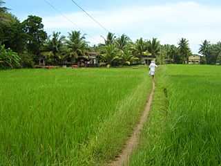
Pavanje is a village in Dakshina Kannada district of Karnataka state, India. It is sited on the north bank of the Nandini River, adjoining National Highway 66 between Udupi and Mangaluru. It lies just outside of Mangalore city and close to Mukka from where the Mangaluru city northern limits start. Pavanje bridge is the entrance to Mangalore city from north. Pavanje lies to south of Haleangadi. The Arabian sea is on west of this village. The village has lush green paddy fields and coconut plantations.

Ghat Roads are access routes into the mountainous Western and Eastern Ghats, mountain ranges of the Indian subcontinent. These roads are remarkable feats of engineering, and most were constructed during the British Raj. Ghat Roads were built to connect to the hill stations established in the mountains for residents to avoid summer heat. They generally served to connect coastal areas with the upper Deccan Plateau.
Kumbhashi or Anegudde or Kumbasi is a village in the Kundapura taluk of Udupi district, India. It lies en route from Udupi towards Kundapura on the National Highway 66 .The Vinayaka Temple is located on hillock called Anegudde, below hillock is known as Kumbasi or Kumbashi.
Chandgad is a Small city and tehsil headquarters of chandgad taluka, of Kolhapur district that is in the Indian state of Maharashtra.

Kapu (Kaup) is a town situated in the Udupi district of Karnataka, India. It lies between the twin cities of Udupi and Mangalore, next to the National Highway 66. The villages Manchakal and Shirva are located near Kapu. It is 13 km south of Udupi and 40 km north of Mangalore. It is known for its lighthouse, the three Mariamman shrines, and the Kapu fort built by Tippu Sultan. Kapu was declared a taluk of the Udupi district by the Government of Karnataka.
Yermal is a settlement in Udupi district of Karnataka state in India, between Uchila and Padubidri on National Highway 66. There are two parts of Yermal, one is Tenka and the other Bada or Badagu.
Udyavara is an ancient port town located 5 km south of Udupi in the Indian state of Karnataka.Jayalaxmi Silks,one of the most famous stand-alone shopping stores in entire Karnataka is situated here. Home to the late Mogaveera Community Leader Ananda Mendon this town is a regional marine industry and fisheries hub. Fish meal products and fish oils from village Pithrody in Udyavara are exported all across the globe.

Katapadi is a village near Udupi in Karnataka, India. It is situated at the junction of National Highway 66 and the roads leading to Mattu and Shankarapura. Katapadi is surrounded by lush green fields, rivers and a beautiful beach. Katapadi is well known for Mattu Gulla, Kambala and jasmine. The name Katapadi is derived from "Kattu paadi" which means "tie it down" in Tulu. Apparently the place is named Katapadi after a lost horse which was found and tied down here.
Hemmadi, also named Hemmady, is a village on the banks of the Chakra River. The village is located in Kundapura taluk of Udupi district, in the state of Karnataka.

Karkala, also known as Karla in Tulu language, is a town and the headquarters of Karkala taluk in the Udupi district of Karnataka, India. Located about 60 km from Mangalore in the Tulu Nadu region of the state, it lies near the foothills of the Western Ghats. Karkala has a number of natural and historical landmarks, and is a major tourist and transit destination due to its strategic location along the way to Hebri, Sringeri, Kalasa, Horanadu, Udupi, Kollur, Subrahmanya and Dharmasthala.
Tallur is a village in the Kundapur taluk of Udupi district in Karnataka State of India. It is less than five kilometres from the town of Kundapura.
Mudarangadi is a village in Kaup Taluk in Udupi District of Karnataka State, India. It belongs to Mysore division. It is located 26 km south of District headquarters Udupi and 352 km from State capital Bangalore.

