Vanlue, Ohio

Last updated

Vanlue, Ohio
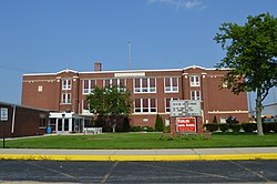
Vanlue High School.jpg
OHMap-doton-Vanlue.png
Location of Vanlue, Ohio
Map of Hancock County Ohio Highlighting Vanlue.png
Location within Hancock County
Coordinates: 40°58′31″N83°28′57″W / 40.97528°N 83.48250°W / 40.97528; -83.48250
Country United States
State Ohio
Counties Hancock
Government
  Type Village council
  MayorRobbie Brooks [1]
Area
[2]
  Total0.36 sq mi (0.92 km2)
  Land0.35 sq mi (0.90 km2)
  Water0.01 sq mi (0.02 km2)
Elevation
[3]
814 ft (248 m)
Population
 (2020)
  Total341
  Density979.89/sq mi (378.48/km2)
Time zone UTC-5 (Eastern (EST))
  Summer (DST) UTC-4 (EDT)
ZIP code
45890
Area code 419
FIPS code 39-79534
GNIS feature ID2400048 [3]
Website https://villageofvanlue.com/home

Vanlue is a village in Hancock County, Ohio, United States. The population was 341 at the 2020 census.

Contents

History

The village is 2 miles west from Sheriden Cave, where native habitation was dated to have occurred around 11,000BC. [4] [5]

Vanlue was platted in 1847 by William Vanlue, and named for him. [6] A post office called Vanlue has been in operation since 1850. [7]

Geography

According to the United States Census Bureau, the village has a total area of 0.36 square miles (0.93 km2), of which 0.35 square miles (0.91 km2) is land and 0.01 square miles (0.03 km2) is water. [8]

Demographics

Historical population
CensusPop.Note
1880 364
1890 352−3.3%
1900 3561.1%
1910 40012.4%
1920 368−8.0%
1930 351−4.6%
1940 3551.1%
1950 3652.8%
1960 3865.8%
1970 53939.6%
1980 390−27.6%
1990 373−4.4%
2000 371−0.5%
2010 359−3.2%
2020 341−5.0%
U.S. Decennial Census [9]

2010 census

As of the census [10] of 2010, there were 359 people, 141 households, and 93 families living in the village. The population density was 1,025.7 inhabitants per square mile (396.0/km2). There were 152 housing units at an average density of 434.3 per square mile (167.7/km2). The racial makeup of the village was 98.3% White, 0.3% African American, 0.6% from other races, and 0.8% from two or more races. Hispanic or Latino of any race were 5.3% of the population.

There were 141 households, of which 34.8% had children under the age of 18 living with them, 53.9% were married couples living together, 11.3% had a female householder with no husband present, 0.7% had a male householder with no wife present, and 34.0% were non-families. 27.0% of all households were made up of individuals, and 12.7% had someone living alone who was 65 years of age or older. The average household size was 2.55 and the average family size was 3.15.

The median age in the village was 35.8 years. 26.5% of residents were under the age of 18; 9.4% were between the ages of 18 and 24; 26.1% were from 25 to 44; 23.7% were from 45 to 64; and 14.2% were 65 years of age or older. The gender makeup of the village was 47.1% male and 52.9% female.

2000 census

As of the census [11] of 2000, there were 371 people, 141 households, and 104 families living in the village. The population density was 1,325.8 inhabitants per square mile (511.9/km2). There were 151 housing units at an average density of 539.6 per square mile (208.3/km2). The racial makeup of the village was 96.77% White, 0.27% African American, 0.27% Native American, 1.08% from other races, and 1.62% from two or more races. Hispanic or Latino of any race were 1.35% of the population.

There were 141 households, out of which 35.5% had children under the age of 18 living with them, 56.7% were married couples living together, 10.6% had a female householder with no husband present, and 26.2% were non-families. 21.3% of all households were made up of individuals, and 14.2% had someone living alone who was 65 years of age or older. The average household size was 2.63 and the average family size was 3.07.

In the village, the population was spread out, with 29.9% under the age of 18, 8.4% from 18 to 24, 26.7% from 25 to 44, 19.7% from 45 to 64, and 15.4% who were 65 years of age or older. The median age was 35 years. For every 100 females there were 93.2 males. For every 100 females age 18 and over, there were 94.0 males.

The median income for a household in the village was $31,786, and the median income for a family was $37,500. Males had a median income of $34,886 versus $21,964 for females. The per capita income for the village was $14,768. None of the families and 3.7% of the population were living below the poverty line, including no under eighteens and 15.4% of those over 64.

Related Research Articles

<span class="mw-page-title-main">McCordsville, Indiana</span> Town in Indiana, United States

McCordsville is a town in Vernon Township, Hancock County, Indiana, United States. The town is a fast-growing suburb of Indianapolis with an estimated population of 8,592 in 2020.

<span class="mw-page-title-main">Shirley, Indiana</span> Town in Indiana, United States

Shirley is a town in Brown Township, Hancock County and Greensboro Township, Henry County, Indiana, United States. The population was 830 at the 2010 census.

Aurora is a town in Hancock County, Maine, United States. The town was named for the goddess of dawn. The population was 93 at the 2020 census.

<span class="mw-page-title-main">Franklin, Maine</span> Town in the state of Maine, United States

Franklin is a town in Hancock County, Maine, United States. The population was 1,567 at the 2020 census. The town's namesake is Benjamin Franklin.

Orland is a town in Hancock County, Maine, United States. The population was 2,221 at the 2020 census.

Osborn is a town in Hancock County, Maine, United States. The population was 65 at the 2020 census.

<span class="mw-page-title-main">Sorrento, Maine</span> Town in Maine, United States

Sorrento is a town in Hancock County, Maine, United States. The population was 279 at the 2020 census.

Waltham is a town in Hancock County, Maine, United States. The population was 332 at the 2020 census.

Boston Township is a civil township of Ionia County in the U.S. state of Michigan. As of the 2020 census, the township population was 6,021.

<span class="mw-page-title-main">Midland, Ohio</span> Village in Ohio, United States

Midland is a village in Clinton County, Ohio, United States. The population was 307 at the 2020 census.

<span class="mw-page-title-main">Arcadia, Ohio</span> Village in Ohio, United States

Arcadia is a village in Hancock County, Ohio, United States. The population was 564 at the 2020 census.

<span class="mw-page-title-main">Benton Ridge, Ohio</span> Village in Ohio, United States

Benton Ridge is a village in Hancock County, Ohio, United States. The population was 272 at the 2020 census. It is within the boundaries of the Liberty-Benton Local School district.

<span class="mw-page-title-main">Jenera, Ohio</span> Village in Ohio, United States

Jenera is a village in Hancock County, Ohio, United States. The population was 257 at the 2020 census. It is surrounded by Van Buren Township and is part of the Cory-Rawson Local School District.

<span class="mw-page-title-main">Mount Blanchard, Ohio</span> Village in Ohio, United States

Mount Blanchard is a village in Hancock County, Ohio, United States. The population was 471 at the 2020 census.

<span class="mw-page-title-main">Mount Cory, Ohio</span> Village in Ohio, United States

Mount Cory is a village in Hancock County, Ohio, United States. The population was 225 at the 2020 census.

<span class="mw-page-title-main">Rawson, Ohio</span> Village in Ohio, United States

Rawson is a village in Hancock County, Ohio, United States. The population was 567 at the 2020 census.

<span class="mw-page-title-main">Rocky Ridge, Ohio</span> Village in Ohio, United States

Rocky Ridge is a village in Ottawa County, Ohio, United States. The population was 312 at the 2020 census.

<span class="mw-page-title-main">Eldorado, Ohio</span> Village in Ohio, United States

Eldorado is a village in Preble County, Ohio, United States. The population was 458 at the 2020 census. It is part of the Dayton Metropolitan Statistical Area.

<span class="mw-page-title-main">Friesland, Wisconsin</span> Village in Wisconsin, United States

Friesland is a village in Columbia County, Wisconsin, United States. The population was 320 at the 2020 census. It is part of the Madison Metropolitan Statistical Area, and was named after Friesland, one of the twelve provinces of the Netherlands.

<span class="mw-page-title-main">Hancock, Wisconsin</span> Village in Wisconsin, United States

Hancock is a village in Waushara County, Wisconsin, United States. The population was 417 at the 2010 census. The village is located within the Town of Hancock.

References

  1. "Village Officials". Hancock County Board Of Elections. Retrieved March 12, 2018.
  2. "ArcGIS REST Services Directory". United States Census Bureau. Retrieved September 20, 2022.
  3. 1 2 U.S. Geological Survey Geographic Names Information System: Vanlue, Ohio
  4. Wolf, Jeannie. "Indian Trail Caverns home to major archaeological find | The Courier". The Courier. Retrieved November 24, 2019.
  5. Robinette, Tom. "The mammoth's lament: Study shows how cosmic impact sparked devastating climate change". phys.org. Retrieved November 24, 2019.
  6. History of Hancock County, Ohio: Containing a History of the County, Its Townships, Towns. Warner, Beers. 1886. p.  366.
  7. "Hancock County". Jim Forte Postal History. Retrieved January 3, 2016.
  8. "US Gazetteer files 2010". United States Census Bureau. Archived from the original on January 25, 2012. Retrieved January 6, 2013.
  9. "Census of Population and Housing". Census.gov. Retrieved June 4, 2015.
  10. "U.S. Census website". United States Census Bureau . Retrieved January 6, 2013.
  11. "U.S. Census website". United States Census Bureau . Retrieved January 31, 2008.