Walnut Grove, Hardin County, Tennessee | |
|---|---|
 Walnut Grove  Walnut Grove | |
| Coordinates: 35°02′24″N88°03′04″W / 35.04000°N 88.05111°W | |
| Country | United States |
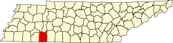
| State | Tennessee |
| County | Hardin |
| Area | |
• Total | 5.756 sq mi (14.91 km2) |
| • Land | 5.756 sq mi (14.91 km2) |
| • Water | 0 sq mi (0 km2) |
| Elevation | 764 ft (233 m) |
| Population (2020) | |
• Total | 359 |
| • Density | 62/sq mi (24/km2) |
| Time zone | UTC-6 (Central (CST)) |
| • Summer (DST) | UTC-5 (CDT) |
| Area code | 731 |
| GNIS feature ID | 1304349 [2] |
Walnut Grove is an unincorporated community and census-designated place (CDP) in Hardin County, Tennessee. Walnut Grove is located on Tennessee State Route 69, north of the Alabama border. As of the 2020 census, its population was 359, [3] down from 396 at 2010. [4]