Waynoka, Oklahoma | |
---|---|
Coordinates: 36°34′56″N98°52′47″W / 36.58222°N 98.87972°W | |
Country | United States |
State | Oklahoma |
County | Woods |
Area | |
• Total | 1.00 sq mi (2.60 km2) |
• Land | 1.00 sq mi (2.60 km2) |
• Water | 0.00 sq mi (0.00 km2) |
Elevation | 1,493 ft (455 m) |
Population (2020) | |
• Total | 708 |
• Density | 705.18/sq mi (272.37/km2) |
Time zone | UTC-6 (Central (CST)) |
• Summer (DST) | UTC-5 (CDT) |
ZIP code | 73860 |
Area code | 580 |
FIPS code | 40-79350 [3] |
GNIS feature ID | 1099446 [2] |
Waynoka is a city in Woods County, Oklahoma, United States. It is located on U.S. Highway 281 and State Highway 14, seventy miles west of Enid. The population, which peaked at 2,018 in 1950, was 708 at the time of the 2020 Census. [4]
Founded in what was then known as Indian Territory, Waynoka was established in 1887 when the Southern Kansas Railroad, a subsidiary of the Atchison, Topeka and Santa Fe Railway, built a rail line through the area. Shortly thereafter, on April 10, 1888, a post office was established, having the distinction of being the first to be established in the Cherokee Outlet. Its economy was based on the railroad and the large ranches in the area. When the Cherokee Outlet opened up for non-Indian settlement in the land run of September 16, 1893, Waynoka became the area's agricultural trade center. [5]
The Santa Fe Railway made the city a major railroad center when it built Oklahoma's largest rail yard in Waynoka. Ultimately employing a thousand machinists, boilermakers, sheet metal mechanics, fire builders, car men, switchmen, and engineers, it operated twenty-four hours a day. One of the nation's largest ice plants was built to supply ice for refrigerator cars hauling perishables on Santa Fe's main line from Chicago to Los Angeles. In addition, a roundhouse, maintenance and repair shops, a reading room, a depot, and a Harvey House were built by the railroad. Although the railroad eventually moved its maintenance operations from Waynoka, it continued train crew changes there until 1986. At the turn of the twenty-first century, between fifty and one hundred trains still passed daily through Waynoka on Oklahoma's fastest and busiest rail line. [5]
Waynoka was also the starting point of the Buffalo and Northwestern Railroad, a 52-mile line linking to Buffalo, Oklahoma, the Harper County seat. [6] [7] The line was finished in 1920, and acquired by the Santa Fe the same year. [7] However, the Santa Fe abandoned the line in 1982. [6]
The predecessor company of TWA, Transcontinental Air Transport, known as "TAT", built Oklahoma's first transcontinental airport in 1929 in Waynoka, at a site five miles northeast of town selected by Charles Lindbergh himself. TAT offered passengers coast-to-coast travel in forty-eight hours, [5] and Waynoka was an important stop on the pioneering route. For the service, TAT utilized not only its own Ford Trimotor aircraft, but also Pullman sleeper cars of the Pennsylvania Railroad and the Santa Fe Railroad for the two overnight segments of the long trip. It was at Waynoka that passengers would transfer from the TAT airplane to the Santa Fe train (going westbound), or conversely, from the Santa Fe train to the TAT plane (heading eastbound). [8] [9] Both Lindbergh and Amelia Earhart, as officers in the company, reportedly became familiar faces in town. [5] After losing $2.7 million in its first eighteen months of operation, TAT in October 1930 merged with Western Air Express to become Transcontinental and Western Airlines, which announced a new route from Kansas City, Kansas, by way of Tulsa, Oklahoma. This ended operations at Waynoka. [10]
Waynoka is linked by US Route 281. [11]
The current Waynoka Municipal Airport (FAA Identifier: 1K5) is one mile southeast of town, and features a paved 3532’ x 60’ runway. [12]
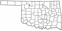
According to the United States Census Bureau, the city has a total area of 1.0 square mile (2.6 km2), all land.
Little Sahara State Park is 4 miles (6.4 km) south of the city. The park offers over 1,600 acres (6.5 km2) of rideable sand dunes ranging in height from 25 to 75 feet (23 m). [13]
Census | Pop. | Note | %± |
---|---|---|---|
1910 | 1,160 | — | |
1920 | 1,500 | 29.3% | |
1930 | 1,840 | 22.7% | |
1940 | 1,584 | −13.9% | |
1950 | 2,018 | 27.4% | |
1960 | 1,794 | −11.1% | |
1970 | 1,444 | −19.5% | |
1980 | 1,377 | −4.6% | |
1990 | 947 | −31.2% | |
2000 | 993 | 4.9% | |
2010 | 927 | −6.6% | |
2020 | 708 | −23.6% | |
U.S. Decennial Census [14] |
As of the census [3] of 2000, there were 993 people, 453 households, and 252 families residing in the city. The population density was 1,034.0 inhabitants per square mile (399.2/km2). There were 582 housing units at an average density of 606.0 per square mile (234.0/km2). The racial makeup of the city was 92.65% White, 2.32% African American, 1.51% Native American, 1.01% from other races, and 2.52% from two or more races. Hispanic or Latino of any race were 5.14% of the population.
There were 453 households, out of which 22.1% had children under the age of 18 living with them, 44.6% were married couples living together, 8.8% had a female householder with no husband present, and 44.2% were non-families. 42.6% of all households were made up of individuals, and 24.3% had someone living alone who was 65 years of age or older. The average household size was 2.07 and the average family size was 2.84.
In the city, the population was spread out, with 22.6% under the age of 18, 7.5% from 18 to 24, 22.4% from 25 to 44, 22.2% from 45 to 64, and 25.5% who were 65 years of age or older. The median age was 43 years. For every 100 females, there were 84.2 males. For every 100 females age 18 and over, there were 79.3 males.
The median income for a household in the city was $20,708, and the median income for a family was $28,833. Males had a median income of $24,063 versus $16,731 for females. The per capita income for the city was $12,493. About 13.5% of families and 16.6% of the population were below the poverty line, including 26.8% of those under age 18 and 9.5% of those age 65 or over.
Waynoka is the home to the Cimarron River Stampede, a rodeo held annually since 1936. It is held on the second weekend of August. [15]
The passenger and freight railroad stations originally built by the Santa Fe remain intact. [16] The Waynoka Santa Fe Depot and Harvey House is listed on the National Register of Historic Places listings in Woods County, Oklahoma.
Other NRHP-listed locations in town are the First Congregational Church at 1887 E. Cecil St., and the Waynoka Telephone Exchange Building at 200 S. Main St.
Carson County is a county located in the U.S. state of Texas. As of the 2020 census, its population was 5,807. The county seat is Panhandle. The county was founded in 1876 and later organized in 1888. It is named for Samuel Price Carson, the first secretary of state of the Republic of Texas.
Logan County is a county located in the U.S. state of Oklahoma. As of the 2020 census, the population was 49,555. Its county seat is Guthrie.
Harper County is a county located in the U.S. state of Oklahoma. As of the 2020 census, the population was 3,272, making it the third-least populous county in Oklahoma. The county seat is Buffalo. It was created in 1907 from the northwestern part of Woodward County, and named for Oscar Green Harper, who was clerk of the Oklahoma Constitutional Convention.
Enterprise is a city in Dickinson County, Kansas, United States. As of the 2020 census, the population of the city was 708.
Manchester is a city in Dickinson County, Kansas, United States. As of the 2020 census, the population of the city was 47.
Baldwin City is a city in Douglas County, Kansas, United States, about 12 miles (19 km) south of Lawrence. As of the 2020 census, the population of the city was 4,826. The city is home to Baker University, the state's oldest four-year university.
Webber is a city in Jewell County, Kansas, United States. As of the 2020 census, the population of the city was 30.
Durham is a city in Marion County, Kansas, United States. As of the 2020 census, the population of the city was 89. The city took its name from Durham cattle. It is located about 8.5 miles (14 km) north of Hillsboro on the west side of K-15 highway next to a railroad.
Lost Springs is a city in Marion County, Kansas, United States. As of the 2020 census, the population of the city was 55. The city was named for a nearby lost spring that was a camping spot along the 19th century Santa Fe Trail. It is located south of Herington, about 0.6 miles west of the intersection of U.S. Route 77 highway and 340th Street next to the Union Pacific Railroad.
Keyes is a town in Cimarron County, Oklahoma, United States. As of the 2020 census, the town’s population was 276.
Fairmont is a town in Garfield County, Oklahoma, United States. The population was 134 at the 2010 census, a decrease from 147 at the 2000 census.
Deer Creek is a town in Grant County, Oklahoma, United States. The population was 130 at the 2010 census, an 11.6 percent decrease from the figure of 147 in 2000. It was named for a nearby stream, which is a tributary of the Salt Fork of the Arkansas River.
Buffalo is a town and county seat of Harper County, Oklahoma, United States. As of the 2020 census, the town's population was 1,039. It was named after the Buffalo Creek valley, in which it is located.
Mill Creek is a town in Johnston County, Oklahoma, United States. The population was 293 as of the 2020 Census. Mill Creek Community is an unincorporated area of Johnston County that surrounds the town and claims to have about 1,000 residents, including those who live within the town limits. Local residents consider the town as the focal point of the community.
Braman is a town in Kay County, Oklahoma, United States. The population was 217 at the 2010 census, a decline of 11.1 percent from the figure of 244 in 2000.
Dewey is a city in Washington County, Oklahoma, United States. The population was 3,179 at the 2000 census and 3,432 at the 2010 census, an increase of 8 percent. It is located near the north side of Bartlesville.
Avard is a settlement in Woods County, Oklahoma, United States. It is southwest of Alva, and northeast of Waynoka. The population was 26 at the 2000 census. After initial growth, Avard began declining in the 1930s. Avard had a post office from June 1, 1895, until November 22, 1963. As of the 2010 census, Avard was listed as disincorporated, although it still appears as a Census-Designated Place.
Drumright is a city in Creek and Payne counties in the U.S. state of Oklahoma. It began as an oil boom town. However, the population has declined as oil production has waned in the area. The population was 2,907 at the 2010 census, a figure almost unchanged from 2,905 in 2000. Drumright and nearby Cushing were at the center of the large, productive Cushing-Drumright Oil Field in the 1910s and 1920s. Now Drumright is home to a festival called The Drumright Monthly Market, where hundreds of visitors come on the first Saturday of every month, seeking crafts and delicacies from all over the region. Drumright is also home to The yearly OilPatch Parade and Jamboree Jog, Annual Cruising the Hills car show, Joseph's Restaurant, and Babe Ruth played on our very own baseball field. We have a sign dedicated to Babe Ruth at the entry to the sports complex area. You can find out more from Jamey Martin at Joseph's and the Museum.
Booker is a town in Lipscomb and Ochiltree counties in Texas, United States. The population was 1,516 as of the 2010 census. It was named for B.F. Booker, a civil engineer for the Panhandle and Santa Fe Railway.
Transcontinental Air Transport (T-A-T) was an airline founded in 1928 by Clement Melville Keys that merged in 1930 with Western Air Express to form what became TWA. Keys enlisted the help of Charles Lindbergh to design a transcontinental network to get government airmail contracts. Lindbergh established numerous airports across the country in this effort.