West End, New York | |
---|---|
Coordinates: 42°27′20″N75°5′56″W / 42.45556°N 75.09889°W | |
Country | United States |
State | New York |
County | Otsego |
Area | |
• Total | 3.73 sq mi (9.66 km2) |
• Land | 3.65 sq mi (9.46 km2) |
• Water | 0.07 sq mi (0.19 km2) |
Elevation | 1,476 ft (450 m) |
Population (2020) | |
• Total | 1,864 |
• Density | 510.13/sq mi (196.95/km2) |
Time zone | UTC-5 (Eastern (EST)) |
• Summer (DST) | UTC-4 (EDT) |
ZIP code | 13820 |
Area code | 607 |
FIPS code | 36-79796 [2] |
GNIS feature ID | 1867423 [3] |
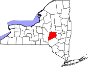
West End is an unincorporated suburban community (and census-designated place) in Otsego County, New York, United States. The population was 1,940 at the 2010 census. [4]
West End is in the town of Oneonta, directly northwest of the city of Oneonta.
West End is located at 42°27′20″N75°5′56″W / 42.45556°N 75.09889°W (42.455516, -75.098969). [5]
According to the United States Census Bureau, the CDP has a total area of 3.7 square miles (9.7 km2), of which 3.7 square miles (9.5 km2) is land and 0.077 square miles (0.2 km2), or 2.03%, is water. [6]
Census | Pop. | Note | %± |
---|---|---|---|
2020 | 1,864 | — | |
U.S. Decennial Census [7] |
As of the census [2] of 2000, there were 1,813 people, 804 households, and 501 families residing in the CDP. The population density was 480.2 inhabitants per square mile (185.4/km2). There were 877 housing units at an average density of 232.3 per square mile (89.7/km2). The racial makeup of the CDP was 97.24% White, 0.66% African American, 0.28% Native American, 1.10% Asian, 0.11% from other races, and 0.61% from two or more races. Hispanic or Latino of any race were 2.10% of the population.
There were 804 households, out of which 26.2% had children under the age of 18 living with them, 45.9% were married couples living together, 11.6% had a female householder with no husband present, and 37.6% were non-families. 31.7% of all households were made up of individuals, and 16.2% had someone living alone who was 65 years of age or older. The average household size was 2.23 and the average family size was 2.76.
In the CDP, the population was spread out, with 21.7% under the age of 18, 6.0% from 18 to 24, 25.9% from 25 to 44, 24.9% from 45 to 64, and 21.5% who were 65 years of age or older. The median age was 43 years. For every 100 females, there were 91.2 males. For every 100 females age 18 and over, there were 87.0 males.
The median income for a household in the CDP was $28,621, and the median income for a family was $31,628. Males had a median income of $30,043 versus $20,568 for females. The per capita income for the CDP was $16,153. About 10.9% of families and 14.9% of the population were below the poverty line, including 23.1% of those under age 18 and none of those age 65 or over.
Highland Acres is a census-designated place (CDP) in Kent County, Delaware, United States. It is part of the Dover, Delaware Metropolitan Statistical Area. The population was 3,459 at the 2010 census.
Vineyards is a census-designated place (CDP) in Collier County, Florida, United States. The population was 3,883 at the 2020 census. It is part of the Naples–Marco Island Metropolitan Statistical Area.
Paukaʻa is a census-designated place (CDP) in Hawaii County, Hawaii, United States. The population was 425 at the 2010 census, down from 495 at the 2000 census. The ZIP code is 96720.
Venetian Village is a census-designated place (CDP) in Lake County, Illinois, United States. Per the 2020 census, the population was 2,761.
Lake Shore is a census-designated place and unincorporated community in Anne Arundel County, Maryland, United States, located east of Pasadena. The population of Lake Shore was 19,477 at the 2010 census.
West Ishpeming is an unincorporated community in Marquette County in the U.S. state of Michigan. The population was 2,552 at the 2020 census. The community is located mostly within Ishpeming Township with a small portion extending south into Tilden Township. The city of Ishpeming borders to the east.
Mesita is a census-designated place (CDP) in Cibola County, New Mexico, United States. The population was 804 at the 2010 census.
Mattydale is a hamlet in Onondaga County, New York, United States. The population was 6,446 at the 2010 census.
Crystal Lakes is a census-designated place (CDP) in Clark County, Ohio, United States. The population was 1,394 at the 2020 census. It is part of the Springfield, Ohio Metropolitan Statistical Area.
Eaton Estates is an unincorporated community and census-designated place (CDP) in Lorain County, Ohio, United States. The population was 1,222 at the 2010 census, down from 1,409 at the 2000 census.
Homeacre-Lyndora is a census-designated place (CDP) in Butler County, Pennsylvania, United States. The population was 6,906 at the 2010 census.
Weissport East is a census-designated place (CDP) in Franklin Township in Carbon County, Pennsylvania. It is part of Northeastern Pennsylvania.
Eastlawn Gardens is a census-designated place (CDP) in Upper Nazareth Township in Northampton County, Pennsylvania. The population of Eastlawn Gardens was 3,307 at the 2010 census. Eastlawn Gardens is part of the Lehigh Valley metropolitan area, which had a population of 861,899 and was the 68th-most populous metropolitan area in the U.S. as of the 2020 census.
Vansant is a census-designated place (CDP) in Buchanan County, Virginia, United States. The population was 470 at the 2010 census. Vansant is located just south of the town of Grundy.
Mirrormont is a census-designated place (CDP) in King County, Washington, United States, south of Issaquah. The population was 3,858 at the 2020 census. Within the last decade, the area has seen a shift in development as larger homes have been constructed in Cedar Grove, the Highlands at Tiger Mountain and Mirrormont.
West Lake Sammamish was a census-designated place (CDP) in King County, Washington, United States. The population was 5,937 at the 2000 census. The census area was annexed by Bellevue in 2001.
Kennebunk is a census-designated place (CDP) comprising the central village in the town of Kennebunk in York County, Maine, United States. The population was 5,214 at the 2010 census, out of a total town population of 10,798. It is part of the Portland–South Portland–Biddeford, Maine Metropolitan Statistical Area.
Laurens is a town in Otsego County, New York, United States. The population was 2,424 at the 2010 census.
Morris is a village in Otsego County, New York, United States. The population was 583 at the 2010 census.
Freeport is a census-designated place (CDP) in the town of Freeport in Cumberland County, Maine, United States. The population was 1,485 at the 2010 census. It is part of the Portland–South Portland–Biddeford, Maine Metropolitan Statistical Area.