West Isles Parish, New Brunswick

Last updated

West Isles
Deer Island
Charlotte County NB - West Iles Parish.png
Location within Charlotte County.
Country Flag of Canada (Pantone).svg  Canada
Province Flag of New Brunswick.svg  New Brunswick
County Charlotte County
Erected1786
Area
[1]
  Land38.32 km2 (14.80 sq mi)
Population
 (2021) [2]
  Total718
  Density18.7/km2 (48/sq mi)
  Change 2016-2021
Decrease2.svg 9.9%
  Dwellings
475
Time zone UTC-4 (AST)
  Summer (DST) UTC-3 (ADT)

West Isles is a geographic parish in Charlotte County, New Brunswick, Canada. [5]

Contents

For governance purposes, it is part of the Southwest rural district, [6] which is a member of the Southwest New Brunswick Service Commission. [7]

Prior to the 2023 governance reform, it comprised a single local service district (LSD), which was a member of the Southwest New Brunswick Service Commission (SNBSC). [8]

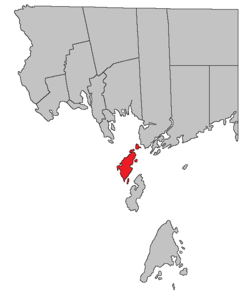
The parish comprises dozens of offshore islands but only the largest, Deer Island, is inhabited. There are no bridges and only Deer Island has ferry service.

Origin of name

Historian William Francis Ganong considered the name to come from the islands' position. [9]

History

West Isles was erected in 1786 as one of the original parishes of the county, [10] including Deer Island, Campobello, and Grand Manan, and islands in Cobscook Bay claimed by Britain.

Boundaries

West Isles Parish is bounded: [3] [11] [12]

Evolution of boundaries

West Isles was originally defined [10] "to contain Deer Island, Campo Bello Island, Grand Manan Island, Moose Island, Frederick Island and Dudley Island, with all the lesser islands contiguous to them, not included in the towns before-mentioned", [lower-alpha 1] a description that included any islands more than 2 miles (3.2 km) offshore except The Wolves in Pennfield Parish.

In 1803 Campobello was erected as its own parish, including nearby minor islands; [13] Campobello inherited West Isles' claims to Cobscook Bay.

In 1816 Grand Manan and was erected as its own parish, including nearby minor islands. [14]

In 1877 the parish's boundary were clarified: Campobello Parish's boundary running through Head Harbour Passage, Saint George Parish's through Letete Passage rather than two miles from the mainland, [15] transferring several islands from Saint George to West Isles.

Local service district

The local service district of the parish of West Isles comprised the entire parish. [16]

The LSD was established in 1970 to assess for fire protection. [17] First aid and ambulance services were added in 1982, [18] recreational facilities in 1987. [19]

In 2022, the LSD assessed community & recreation services as well as the basic LSD services of fire protection, police services, land use planning, emergency measures, and dog control. [20] The taxing authority is 517.00 West Isles.

Communities

Communities at least partly within the parish. [11] [12] [21] italics indicate a name no longer in official use

Bodies of water

Bodies of water [lower-alpha 2] at least partly within the parish. [11] [12] [21] italics indicate a name no longer in official use

Islands

Islands at least partly within the parish. [11] [12] [21] italics indicate a name no longer in official use

Other notable places

Parks, historic sites, and other noteworthy places at least partly within the parish. [11] [12] [21] [22]

Demographics

Population

Canada census – West Isles Parish, New Brunswick community profile
2016 2011
Population797 (+9.0% from 2011)731 (-11.3% from 2006)
Land area38.35 km2 (14.81 sq mi)38.01 km2 (14.68 sq mi)
Population density20.8/km2 (54/sq mi)19.2/km2 (50/sq mi)
Median age48.4 (M: 49.0, F: 46.8)47.5 (M: 46.5, F: 48.4)
Private dwellings467 (total) 485 (total) 
Median household income$56,736$.N/A
Notes: 2011 income data for this area has been suppressed for data quality or confidentiality reasons.
References: 2016 [23] 2011 [24] earlier [25] [26]
Historical Census Data - West Isles Parish, New Brunswick
YearPop.±%
1991 826    
1996 851+3.0%
2001 851+0.0%
YearPop.±%
2006 824−3.2%
2011 731−11.3%
2016 797+9.0%
YearPop.±%
2021 718−9.9%
[27] [2] [28] [1]

Language

Canada Census Mother Tongue - West Isles Parish, New Brunswick [27]
CensusTotal
English
French
English & French
Other
YearResponsesCountTrendPop %CountTrendPop %CountTrendPop %CountTrendPop %
2011
730
710Decrease2.svg 13.4%97.26%15Increase2.svg n/a%2.05%5Increase2.svg n/a%0.69%0Steady2.svg 0.0%0.00%
2006
820
820Decrease2.svg 1.2%100.00%0Decrease2.svg 100.0%0.00%0Steady2.svg 0.0%0.00%0Decrease2.svg 100.0%0.00%
2001
850
830Decrease2.svg 2.4%97.65%10Increase2.svg n/a%1.18%0Steady2.svg 0.0%0.00%10Increase2.svg n/a%1.18%
1996
850
850n/a100.00%0n/a0.00%0n/a0.00%0n/a0.00%

Access Routes

Highways and numbered routes that run through the parish, including external routes that start or finish at the parish limits: [29]

See also

Notes

  1. Use of long s modernised for readability.
  2. Not including brooks, ponds or coves.
  3. 1 2 A small bay.
  4. 1 2 A tidal flow between islands.
  5. White Horse Island. This difference in spelling is not unique.

Related Research Articles

<span class="mw-page-title-main">Grand Manan</span> Village in New Brunswick, Canada

Grand Manan is a Canadian island in the Bay of Fundy, part of the province of New Brunswick. Grand Manan is also the name of an incorporated village, which includes the main island and numerous nearby islands; White Head Island, small islands near it, and Machias Seal Island are not part of the village.

<span class="mw-page-title-main">Campobello Island</span> Island in Campobello, New Brunswick, Canada

Campobello Island is the largest and only inhabited island in Campobello, a geographic parish in southwestern New Brunswick, Canada, near the border with Maine, United States. The island's permanent population in 2021 was 949. It is the site of the Roosevelt Campobello International Park, Head Harbour Lighthouse, and of Herring Cove Provincial Park.

Deer Island is one of the Fundy Islands in the Bay of Fundy, Canada. It is at the entrance to Passamaquoddy Bay. The island was first settled by colonists around 1770.

<span class="mw-page-title-main">Passamaquoddy Bay</span> International inlet of the Bay of Fundy

Passamaquoddy Bay is an inlet of the Bay of Fundy, between the U.S. state of Maine and the Canadian province of New Brunswick, at the mouth of the St. Croix River. Most of the bay lies within Canada, with its western shore bounded by Washington County, Maine. The southernmost point is formed by West Quoddy Head on the U.S. mainland in Lubec, Maine; and runs northeasterly through Campobello Island, New Brunswick, engulfing Deer Island, New Brunswick, to the New Brunswick mainland head at L'Etete, New Brunswick in Charlotte County, New Brunswick.

<span class="mw-page-title-main">Dalhousie Parish, New Brunswick</span> Parish in New Brunswick, Canada

Dalhousie is a geographic parish in Restigouche County, New Brunswick, Canada.

<span class="mw-page-title-main">Bathurst Parish, New Brunswick</span> Parish in New Brunswick, Canada

Bathurst is a geographic parish in Gloucester County, New Brunswick, Canada.

<span class="mw-page-title-main">Shippegan Parish, New Brunswick</span> Parish in New Brunswick, Canada

Shippegan is a geographic parish in Gloucester County, New Brunswick, Canada. Located in the northeastern corner of the province at the end of the Acadian Peninsula, the parish consists of the three main islands of Taylor, Lamèque, and Miscou, along with several smaller islands and tidal wetlands; Taylor Island is now joined to the mainland by an isthmus, which is crossed by a causeway.

<span class="mw-page-title-main">Simonds Parish, Carleton County, New Brunswick</span> Parish in New Brunswick, Canada

Simonds is a geographic parish in Carleton County, New Brunswick, Canada, located north of Woodstock on the western bank of the Saint John River.

<span class="mw-page-title-main">Wakefield Parish, New Brunswick</span> Parish in New Brunswick, Canada

Wakefield is a geographic parish in Carleton County, New Brunswick, Canada, located north on the west bank of the Saint John River north of Woodstock.

<span class="mw-page-title-main">Saint Andrews Parish, New Brunswick</span> Parish in Canada

Saint Andrews Parish is a geographic parish in Charlotte County, New Brunswick, Canada, located east of St. Stephen.

<span class="mw-page-title-main">Hopewell Parish, New Brunswick</span> Parish in New Brunswick, Canada

Hopewell is a geographic parish in eastern Albert County, New Brunswick, Canada.

<span class="mw-page-title-main">Harvey Parish, New Brunswick</span> Parish in New Brunswick, Canada

Harvey is a geographic parish in southern Albert County, New Brunswick, Canada.

<span class="mw-page-title-main">Simonds Parish, Saint John County, New Brunswick</span> Parish in New Brunswick, Canada

Simonds is a geographic parish in Saint John County, New Brunswick, Canada.

<span class="mw-page-title-main">Musquash Parish, New Brunswick</span> Parish in New Brunswick, Canada

Musquash is a geographic parish in Saint John County, New Brunswick, Canada.

<span class="mw-page-title-main">Lepreau Parish, New Brunswick</span> Parish in Canada

Lepreau is a geographic parish in Charlotte County, New Brunswick, Canada, west of Saint John.

<span class="mw-page-title-main">Pennfield Parish, New Brunswick</span> Parish in Canada

Pennfield is a geographic parish in Charlotte County, New Brunswick, Canada, located west of Saint John located east of St. George and west of Saint John.

<span class="mw-page-title-main">Saint George Parish, New Brunswick</span> Parish in Canada

Saint George is a geographic parish in Charlotte County, New Brunswick, Canada, located between St. Stephen and Saint John.

<span class="mw-page-title-main">Saint Patrick Parish, New Brunswick</span> Parish in Canada

Saint Patrick is a geographic parish in Charlotte County, New Brunswick, Canada, located west of St. George and Saint Andrews.

<span class="mw-page-title-main">Saint David Parish, New Brunswick</span> Parish in Canada

Saint David is a geographic parish in Charlotte County, New Brunswick, Canada, located northeast of St. Stephen and northwest of Saint Andrews.

<span class="mw-page-title-main">Grand Manan Parish, New Brunswick</span> Parish in Canada

Grand Manan is a geographic parish in Charlotte County, New Brunswick, Canada, comprising one village and part of a rural district; the rural district portion was formerly a local service district (LSD); both of which are members of the Southwest New Brunswick Service Commission (SNBSC). The parish includes Grand Manan Island and numerous lesser islands, only one of which has permanent year-round inhabitants.

References

  1. 1 2 "Census Profile". Statistics Canada. 26 October 2022. Retrieved 30 October 2022.
  2. 1 2 "West Isles, New Brunswick (Code 1302006) and Charlotte, New Brunswick (Code 1302) (table)". 2011 Census of Population . Statistics Canada. Retrieved 16 July 2012.
  3. 1 2 "Chapter T-3 Territorial Division Act". Government of New Brunswick. Retrieved 5 June 2023.
  4. "Chapter I-13 Interpretation Act". Government of New Brunswick. Retrieved 5 June 2023.
  5. The Territorial Division Act [3] divides the province into 152 parishes, the cities of Saint John and Fredericton, and one town of Grand Falls. The Interpretation Act [4] clarifies that parishes include any local government within their borders.
  6. "Southwest Regional Service Commission: RD 10". Government of New Brunswick. Retrieved 5 June 2023.
  7. "Regions Regulation – Regional Service Delivery Act". Government of New Brunswick. 21 July 2022. Retrieved 5 June 2023.
  8. "Communities in each of the 12 Regional Service Commissions (RSC) / Les communautés dans chacune des 12 Commissions de services régionaux (CSR)" (PDF), Government of New Brunswick, July 2017, retrieved 1 February 2021
  9. Ganong, William F. (1896). A Monograph of the Place-Nomenclature of the Province of New Brunswick. Royal Society of Canada. p. 279. Retrieved 17 March 2021.
  10. 1 2 "26 Geo. III Chapter I. An Act for the better ascertaining and confirming the Boundaries of the several Counties within this Province, and for subdividing them into Towns or Parishes.". Acts of the General Assembly of His Majesty's Province of New-Brunswick, passed in the year 1786. Saint John, New Brunswick: Government of New Brunswick. 1786. pp. 3–12. Retrieved 20 March 2021.
  11. 1 2 3 4 5 "No. 166". Provincial Archives of New Brunswick. Department of Natural Resources and Energy Development. Retrieved 4 July 2021.
  12. 1 2 3 4 5 "489" (PDF). Transportation and Infrastructure. Government of New Brunswick. Retrieved 4 July 2021. Remainder of parish on mapbooks 490, 497, 500, and 501 at same site.
  13. "43 Geo. III c. 4 An Act, in addition to an Act, intitled 'an Act for the better ascertaining and confirming the Boundaries of the several Counties within this Province, and for subdividing them into Towns and Parishes.'". Acts of the General Assembly of His Majesty's Province of New-Brunswick. Passed in the Year 1803. Saint John, New Brunswick: Government of New Brunswick. 1803. p. 479. Retrieved 27 March 2021.
  14. "56 Geo. III c. 10 An Act to constitute the Island of Grand-Manan and its appurtenances in the County of Charlotte into a distinct Town or Parish.". Acts of the General Assembly of His Majesty's Province of New-Brunswick. Passed in the Year 1816. Fredericton: Government of New Brunswick. 1816. p. 28. Retrieved 27 March 2021.
  15. "Chapter 2 The Division of the Province into Counties, Towns, and Parishes.". The Consolidated Statutes of New Brunswick. Fredericton: Government of New Brunswick. 1877. pp. 56–85. Available as a free ebook from Google Books.
  16. "New Brunswick Regulation 84-168 under the Municipalities Act (O.C. 84-582)". Government of New Brunswick. Retrieved 6 February 2021.
  17. "Regulation 70–63 under the Municipalities Act (O. C. 70–385)". The Royal Gazette. 128. Fredericton: 343–344. 17 June 1970.
  18. New Brunswick Regulation 82-138. These were erroneously removed in Regulation 84-168, which rewrote the entire province, then restored in Regulation 86-8.
  19. New Brunswick Regulation 87-42.
  20. "2020 Local Government Statistics for New Brunswick" (PDF). Department of Environment and Local Government. p. 55. Retrieved 6 February 2021.
  21. 1 2 3 4 "Search the Canadian Geographical Names Database (CGNDB)". Government of Canada. Retrieved 4 July 2021.
  22. "Explore New Brunswick's Protected Natural Areas". GeoNB. Retrieved 4 July 2021.
  23. "2016 Community Profiles". 2016 Canadian Census . Statistics Canada. 12 August 2021. Retrieved 7 September 2019.
  24. "2011 Community Profiles". 2011 Canadian Census . Statistics Canada. 21 March 2019. Retrieved 19 March 2014.
  25. "2006 Community Profiles". 2006 Canadian Census . Statistics Canada. 20 August 2019.
  26. "2001 Community Profiles". 2001 Canadian Census . Statistics Canada. 18 July 2021.
  27. 1 2 Statistics Canada: 1996, 2001, 2006, 2011 census
  28. "Census Profile, 2016 Census: West Isles, Parish [Census subdivision], New Brunswick". Statistics Canada. Retrieved 7 September 2019.
  29. Atlantic Canada Back Road Atlas ISBN   978-1-55368-618-7 Pages 4, 12


44°58′54″N66°56′40″W / 44.981799°N 66.944504°W / 44.981799; -66.944504 (West Isles Parish, New Brunswick)