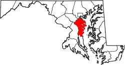
West River, Maryland

Last updated

West River, Maryland
USA Maryland location map.svg
Red pog.svg
West River, Maryland
Location within the state of Maryland
Usa edcp location map.svg
Red pog.svg
West River, Maryland
West River, Maryland (the United States)
Coordinates: 38°51′01″N76°35′46″W / 38.85028°N 76.59611°W / 38.85028; -76.59611
Country Flag of the United States.svg United States
State Flag of Maryland.svg Maryland
County Flag of Anne Arundel County, Maryland.png Anne Arundel
Elevation
82 ft (25 m)
Time zone UTC-5 (Eastern (EST))
  Summer (DST) UTC-4 (EDT)
ZIP code
20778 [1]
Area codes 410,443 and 667

West River is an unincorporated community in Anne Arundel County, Maryland, United States. [2]

Notable people

References

  1. "West River ZIP Code". zipdatamaps.com. 2022. Retrieved November 18, 2022.
  2. "Geographic Names Information System". West River (Populated Place). U.S. Geological Survey. January 29, 2009.