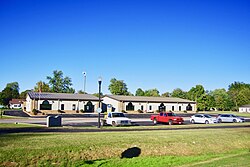
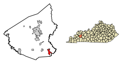
White Plains, Kentucky | |
---|---|
Nickname: little prairie | |
Coordinates: 37°11′4″N87°23′5″W / 37.18444°N 87.38472°W Coordinates: 37°11′4″N87°23′5″W / 37.18444°N 87.38472°W | |
Country | United States |
State | Kentucky |
County | Hopkins |
Area | |
• Total | 3.33 sq mi (8.62 km2) |
• Land | 3.25 sq mi (8.42 km2) |
• Water | 0.08 sq mi (0.20 km2) |
Elevation | 417 ft (127 m) |
Population (2020) | |
• Total | 829 |
• Density | 254.92/sq mi (98.41/km2) |
Time zone | UTC-6 (Central (CST)) |
• Summer (DST) | UTC-5 (CDT) |
ZIP code | 42464 |
Area code(s) | 270 & 364 |
FIPS code | 21-82722 |
GNIS feature ID | 0506635 |
White Plains is a home rule-class city in Hopkins County, Kentucky, United States. The population was 884 at the 2010 census, [2] up from 800 at the 2000 census.
White Plains was established in 1853, and was originally known as "Little Prairie." With the arrival of the railroad in 1870, Little Prairie became the shipping point for a community then known as "White Plains" (modern Fruit Hill) further to the south in Christian County, and thus became known as "White Plains Station," or "New White Plains." When the postmaster of the Christian County community renamed it "Fruit Hill," the "New" was dropped from the name of the Hopkins County city. [3] [4]
White Plains is located in southeastern Hopkins County at 37°11′4″N87°23′5″W / 37.18444°N 87.38472°W (37.184489, -87.384739). [5] U.S. Route 62 passes through the northern part of the community, leading east 13 miles (21 km) to Greenville and west 4 miles (6 km) to Nortonville.
According to the United States Census Bureau, White Plains has a total area of 3.18 square miles (8.24 km2), of which 3.11 square miles (8.05 km2) are land and 0.07 square miles (0.19 km2), or 2.34%, are water. [2]
Historical population | |||
---|---|---|---|
Census | Pop. | %± | |
1880 | 35 | — | |
1890 | 59 | 68.6% | |
1900 | 200 | 239.0% | |
1910 | 281 | 40.5% | |
1920 | 315 | 12.1% | |
1930 | 350 | 11.1% | |
1940 | 382 | 9.1% | |
1950 | 385 | 0.8% | |
1960 | 359 | −6.8% | |
1970 | 729 | 103.1% | |
1980 | 859 | 17.8% | |
1990 | 598 | −30.4% | |
2000 | 800 | 33.8% | |
2010 | 884 | 10.5% | |
2020 | 829 | −6.2% | |
U.S. Decennial Census [6] |
As of the census [7] of 2000, there were 800 people, 295 households, and 225 families residing in the city. The population density was 298.6 inhabitants per square mile (115.3/km2). There were 328 housing units at an average density of 122.4 per square mile (47.3/km2). The racial makeup of the city was 98.25% White, 0.62% Black or African American, 0.25% Asian, 0.25% from other races, and 0.62% from two or more races. Hispanic or Latino of any race were 2.50% of the population.
There were 295 households, out of which 36.9% had children under the age of 18 living with them, 61.7% were married couples living together, 11.2% had a female householder with no husband present, and 23.4% were non-families. 22.4% of all households were made up of individuals, and 10.5% had someone living alone who was 65 years of age or older. The average household size was 2.71 and the average family size was 3.14.
In the city, the population was spread out, with 27.1% under the age of 18, 10.3% from 18 to 24, 29.5% from 25 to 44, 23.6% from 45 to 64, and 9.5% who were 65 years of age or older. The median age was 33 years. For every 100 females, there were 100.0 males. For every 100 females age 18 and over, there were 99.0 males.
The median income for a household in the city was $29,205, and the median income for a family was $32,321. Males had a median income of $30,833 versus $16,818 for females. The per capita income for the city was $13,187. About 20.3% of families and 23.6% of the population were below the poverty line, including 34.5% of those under age 18 and 20.8% of those age 65 or over.
Webster County is a county located in the U.S. state of Kentucky. As of the 2020 census, the population was 13,017. Its county seat is Dixon. It is the southernmost county in the Evansville, IN–KY Metropolitan Statistical Area. The county was formed in 1860 from parts of Henderson, Hopkins, and Union Counties and named for American statesman Daniel Webster (1782-1852). It was mainly pro-Confederate during the American Civil War and was the site of several skirmishes and some guerrilla warfare. Since 2018 it has been a moist county, with Providence and Sebree voting to allow alcohol sales, and Clay doing so in 2022.
Hopkins County is a county located in the western part of the U.S. state of Kentucky. As of the 2020 census, the population was 45,423. Its county seat is Madisonville. Hopkins County was created December 9, 1806 from Henderson County. It was named for General Samuel Hopkins, an officer in both the American Revolutionary War and War of 1812, and later a Kentucky legislator and U.S. Congressman.
Bellmont is a village in Bellmont Precinct, Wabash County, Illinois, United States. The population was 297 at the 2000 census.
Vining is a city in Tama County, Iowa, United States. The population was 54 at the time of the 2020 census.
Crofton is a home rule-class city in Christian County, Kentucky, in the United States. The population was 749 at the 2010 census.
Corydon is a home rule-class city and former coal town in Henderson County, Kentucky, United States. The population was 720 at the 2010 census.
Earlington is a home rule-class city in Hopkins County, Kentucky, in the United States. As of the 2010 census, the city had a population of 1,413, down from 1,649 at the 2000 census.
Hanson is a home rule-class city in Hopkins County, Kentucky, in the United States. The population was 742 at the 2010 census, up from 625 at the 2000 census.
Mortons Gap is a home rule-class city in Hopkins County, Kentucky, in the United States. The population was 863 at the 2010 census, down from 952 at the 2000 census.
Nebo is a home rule-class city in Hopkins County, Kentucky, in the United States. The population was 236 as of the 2010 census.
Nortonville is a home rule-class city in Hopkins County, Kentucky, in the United States. The population was 1,204 as of the 2010 census.
St. Charles is a home rule-class city in Hopkins County, Kentucky, United States. The population was 277 at the 2010 U.S. Census.
Glenview Manor is a home rule-class city in Jefferson County, Kentucky, United States. The population was 191 at the 2010 census.
Calhoun is a home rule-class city in McLean County, Kentucky, United States. The population was 763 at the 2010 census. It is the county seat of McLean County. It is included in the Owensboro, Kentucky Metropolitan Statistical Area.
Island is a home rule-class city in McLean County, Kentucky, in the United States. The population was 458 at the 2010 census. It is included in the Owensboro metropolitan area.
Uniontown is a home rule-class city in Union County, Kentucky, United States. The population was 1,002 at the 2010 census. The John T. Myers Locks and Dam, once known as Uniontown Locks and Dam, is located downriver 3½ miles.
Waverly is a home rule-class city in Union County, Kentucky, United States. The population was 297 at the 2000 census. Founded in 1870, the city was named for founder Hugh McElroy's nephew.
Wheatcroft is a home rule-class city in Webster County, Kentucky, United States. The population was 173 at the 2000 census.
Dawson Springs is a home rule-class city in Hopkins and Caldwell counties in the U.S. state of Kentucky. As of the 2020 census, the population of the city was 2,452.
Eubank is a home rule-class city in Pulaski and Lincoln counties in southern Kentucky. The population was 319 at the 2010 census.