Related Research Articles

Ottawa County is a county located in the northeastern corner of the U.S. state of Oklahoma. As of the 2010 census, the population was 31,848. Its county seat is Miami. The county was named for the Ottawa Tribe of Oklahoma. It is also the location of the federally recognized Modoc Tribe of Oklahoma and the Quapaw Tribe of Indians, which is based in Quapaw.

Zinc is a town near the east-central edge of Boone County, Arkansas, United States. The population was 103 at the 2010 census. It is part of the Harrison Micropolitan Statistical Area. A chapter of the Ku Klux Klan operates a training and information center in Zinc.
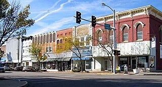
LaSalle is a city in LaSalle County, Illinois, United States, located at the intersection of Interstates 39 and 80. It is part of the Ottawa, IL Micropolitan Statistical Area. Originally platted in 1837 over one square mile, the city's boundaries have grown to 12 sq mi (31 km2). City boundaries extend from the Illinois River and Illinois and Michigan Canal to a mile north of Interstate 80 and from the city of Peru on the west to the village of North Utica on the east. Starved Rock State Park is located approximately 5 mi (8 km) to the east. The population was 9,609 at the 2010 census, and was estimated to have decreased to 8,986 by July 2019. LaSalle and its twin city, Peru, make up the core of the Illinois Valley. Due to their combined dominance of the zinc processing industry in the early 1900s, they were collectively nicknamed "Zinc City."

Palmerton is a borough in Carbon County, Pennsylvania, United States. It is located in the Coal Region of the state, and is on the outskirts of the Lehigh Valley. The borough's population was 5,414 at the 2010 census.
Mascot is a census-designated place (CDP) in Knox County, Tennessee, United States. The population was 2,411 at the 2010 census.

Mineral Point is a city in Iowa County, Wisconsin, United States. The city is located within the Town of Mineral Point. Mineral Point is part of the Madison Metropolitan Statistical Area. Wisconsin's third oldest city, Mineral Point was settled in 1827, becoming a lead and zinc mining center during the 19th and early 20th centuries. Today the city's historical character has made it a regional tourist destination. The population was 2,487 at the 2010 census.
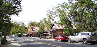
Coloma is a census-designated place in El Dorado County, California, US. It is approximately 36 miles (58 km) northeast of Sacramento, California. Coloma is most noted for being the site where James W. Marshall found gold in the Sierra Nevada foothills, at Sutter's Mill on January 24, 1848, leading to the California Gold Rush. Coloma's population is 529.

Two Harbors, colloquially known as "The Isthmus", is a small unincorporated community island village on the island of Santa Catalina Island, California, with a population of 298. It is the second center of population on the island, besides the city of Avalon. It is mainly a resort village. It has only one restaurant, one hotel and one general store. The village has about 150 permanent residents who live on the isthmus year-round. One notable feature was the one-room schoolhouse which closed in 2014.

The John Muir National Historic Site is located in the San Francisco Bay Area, in Martinez, Contra Costa County, California. It preserves the 14-room Italianate Victorian mansion where the naturalist and writer John Muir lived, as well as a nearby 325-acre tract of native oak woodlands and grasslands historically owned by the Muir family. The main site is on the edge of town, in the shadow of State Route 4, also known as the "John Muir Parkway."

Shipham is a village and civil parish in Somerset, England. It is on the western edge of the Mendip Hills near the A38, approximately 15 miles (24 km) south of Bristol. It is in the local government district of Sedgemoor. The parish includes the village of Rowberrow and the hamlet of Star. The parish population, according to the 2011 census, is 1,087.
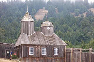
Fort Ross State Historic Park is a historical state park in Sonoma County, California, including the former Russian fur trading outpost of Fort Ross plus the adjacent coastline and native coast redwood forests extending inland. Fort Ross, active from 1812 to 1842, was the southernmost settlement in the Russian colonization of the Americas. The 3,393-acre (1,373 ha) park was established in 1909. The site is a Sonoma County Historic Landmark.

This is a list of the National Register of Historic Places listings in Los Angeles County, California.

Pendarvis is a historic site located in Mineral Point, Iowa County, Wisconsin, United States. The site, which is listed on the National Register of Historic Places, is made up of several 19th century cabins built by Cornish immigrants who came to Mineral Point to mine lead. Today the site is owned by the Wisconsin Historical Society and serves as a museum of Wisconsin's early lead mining history. Programs at the site also interpret the groundbreaking preservation work by Robert Neal and Edgar Hellum, begun during the Great Depression.

Olompali State Historic Park is a 700-acre (2.8 km2) California State Park in Marin County, California. It is constituted of the former Rancho Olómpali and was the site of the famed Battle of Olómpali during the Bear Flag Revolt. Rancho Olómpali was purchased by the Californian government in 1977, which turned it into a public park.

The Cerro Gordo Mines are a collection of abandoned mines located in the Inyo Mountains, in Inyo County, near Lone Pine, California. Mining operations spanned 1866 to 1957, producing high grade silver, lead, and zinc ore. Some ore was smelted on site, but larger capacity smelters were eventually constructed along the shore of nearby Owens Lake.

The Wassama Round House State Historic Park is in the Sierra Nevada foothills, in Madera County of central California.

This is a list of the National Register of Historic Places listings in Pasadena, California.
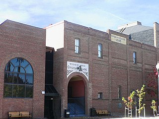
The Woodland Opera House, listed on the National Register of Historic Places and a California Historical Landmark, is one of four fully functioning 19th century opera houses in California. It is a contributing property to the Downtown Historic District of Woodland, California.

Red Dog was a California gold rush mining town located in the Gold Country in south-central Nevada County, California, United States, 6 mi (9.7 km) northeast of Chicago Park. Red Dog Hill, a mine and campsite, was founded by three men all under the age of 22, and was named by their youngest, a 15-year-old prospector. As mining operations grew, the campsite became a settlement, and then a town with a population of 2,000 residents, before it was eventually abandoned. Still considered important today, Red Dog Townsite is listed on the National Register of Historic Places. Red Dog has been noted for its unusual place name.
Atlanta is an unincorporated community located in San Joaquin County, California. Its elevation is 62 ft and is located at 37°48′47″N121°07′15″W.
References
- 1 2 3 Durham, David L. (1998). California's Geographic Names: A Gazetteer of Historic and Modern Names of the State. Clovis, Calif.: Word Dancer Press. p. 525. ISBN 1-884995-14-4.

| | This Nevada County, California-related article is a stub. You can help Wikipedia by expanding it. |