Iwi are the largest social units in New Zealand Māori society. In Māori, iwi roughly means 'people' or 'nation', and is often translated as "tribe", or "a confederation of tribes". The word is both singular and plural in the Māori language, and is typically pluralised as such in English.
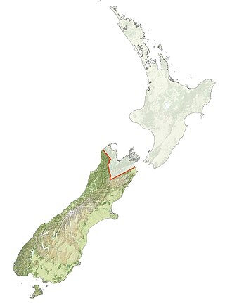
Ngāi Tahu, or Kāi Tahu, is the principal Māori iwi (tribe) of the South Island. Its takiwā is the largest in New Zealand, and extends from the White Bluffs / Te Parinui o Whiti, Mount Mahanga and Kahurangi Point in the north to Stewart Island / Rakiura in the south. The takiwā comprises 18 rūnanga corresponding to traditional settlements. According to the 2018 census an estimated 74,082 people affiliated with the Kāi Tahu iwi.

Otakou is a settlement within the boundaries of the city of Dunedin, New Zealand. It is located 25 kilometres from the city centre at the eastern end of Otago Peninsula, close to the entrance of Otago Harbour. Though a small fishing village, Otakou is important in the history of Otago for several reasons. The settlement is the modern centre and traditional home of the Ōtākou rūnanga (assembly) of Ngāi Tahu. In 1946 Otakou Fisheries was founded in the township; this was later to become a major part of the Otago fishing industry.
Waitaha, an early Māori iwi, inhabited the South Island of New Zealand. They were largely absorbed via marriage and conquest – first by the Ngāti Māmoe and then by Ngāi Tahu – from the 16th century onward. Today those of Waitaha descent are represented by the Ngāi Tahu iwi. Like Ngāi Tahu today, Waitaha was itself a collection of various ancient iwi. Kāti Rākai was said to be one of Waitaha's hapū.
Claims and settlements under the Treaty of Waitangi have been a significant feature of New Zealand politics since the Treaty of Waitangi Act 1975 and the Waitangi Tribunal that was established by that act to hear claims. Successive governments have increasingly provided formal legal and political opportunity for Māori to seek redress for what are seen as breaches by the Crown of guarantees set out in the Treaty of Waitangi. While it has resulted in putting to rest a number of significant longstanding grievances, the process has been subject to criticisms including those who believe that the redress is insufficient to compensate for Māori losses. The settlements are typically seen as part of a broader Māori Renaissance.

Lyttelton Harbour / Whakaraupō is a major inlet on the northwest side of Banks Peninsula, on the coast of Canterbury, New Zealand; the other major inlet is Akaroa Harbour, which enters from the southern side of the peninsula. Whakaraupō enters from the northern coast of the peninsula, heading in a predominantly westerly direction for approximately 15 km (9.3 mi) from its mouth to the aptly-named Head of the Bay near Teddington. The harbour sits in an eroded caldera of the ancient Banks Peninsula Volcano, the steep sides of which form the Port Hills on its northern shore.

Ripapa Island, also known earlier as Ripa Island, located just off the shore of Lyttelton Harbour, has played many roles in the history of New Zealand. A Māori fortified pā there played a key role in an internal struggle for the South Island Ngāi Tahu tribe in the early 19th century. Between 1873 and 1885, the island hosted a quarantine station, which was also used as a temporary prison for members of the Parihaka Māori settlement in Taranaki. Fort Jervois was built in 1886 as part of system of defences against a feared Russian invasion. The fort was in military use until the end of World War I, and again during World War II. It is the most complete Russian-scare fort still existing in New Zealand.

Port Levy is a long, sheltered bay and settlement on Banks Peninsula in Canterbury, New Zealand. The current population is under 100, but in the mid-19th century it was the largest Māori settlement in Canterbury with a population of about 400 people. It is named after Solomon Levey, an Australian merchant and ship owner who sent a number of trading vessels to the Banks Peninsula area during the 1820s.
The history of the Canterbury Region of the South Island of New Zealand dates back to settlement by Māori people in about the 14th century.
The Otago region of New Zealand is one of the more isolated places of the inhabited earth. Its high latitude, elevation and distance from larger foreign and domestic population centres have defined Otago at each stage of its history.
The following lists events that happened during 1832 in New Zealand.
Uruaokapuarangi was one of the great ocean-going, voyaging canoes that was used in the migrations that settled the South Island according to Māori tradition.
Wharetutu Te Aroha Stirling was a notable New Zealand tribal leader and conservationist. Of Māori descent, she identified with the Ngāi Tahu iwi. She was a major participant in the Ngāi Tahu Treaty of Waitangi claim and settlement process. She was born in Lyttelton, North Canterbury, New Zealand in 1924.

The Ngāi Tahu Claims Settlement Act 1998 is an act of Parliament passed in New Zealand relating to Ngāi Tahu, the principal Māori iwi (tribe) of Te Waipounamu the South Island. It was negotiated in part by Henare Rakiihia Tau. The documents in relation to the Ngāi Tahu land settlement claim are held at Tūranga, the main public library in Ōtautahi Christchurch.

Te Rāpaki-o-Te Rakiwhakaputa, commonly known as Rāpaki or Rapaki, is a small settlement within the Lyttelton Harbour basin.

The Takiroa Rock Art Shelter is an archaeological site located along State Highway 83 near Duntroon, New Zealand. The site features a limestone rock shelter containing several pieces of Māori rock art, dating between 1400 and 1900 AD. The shelter is open to public viewing, with fences constructed to protect the artwork from damage.

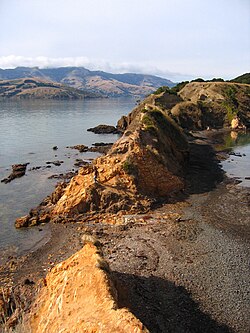
Takapūneke, with the location also known as Red House Bay, is a former kāinga—an unfortified Māori village—adjacent to present-day Akaroa, New Zealand. Takapūneke was a major trading post for the local iwi (tribe), Ngāi Tahu, as there was safe anchorage for European vessels. The site is of significance to Ngāi Tahu as their tribal chief, Tama-i-hara-nui, was captured here by North Island Ngāti Toa chief Te Rauparaha, and then tortured and killed. The village itself was raided and subject of a massacre, with the events subsequently called the Elizabeth affair. There is a direct link from the massacre in 1830 to the signing of the Treaty of Waitangi in 1840, giving the site a status of national significance.

Kemp's Deed, also known as the Canterbury Purchase, Kemp's Purchase, or the Ngāi Tahu Purchase, is the purchase of Canterbury, New Zealand, from some Ngāi Tahu chiefs by Tacy Kemp on behalf of the New Zealand Company. It is the Crown's largest purchase from Ngāi Tahu and the "least carefully transacted". The grievance caused by the Crown was settled 150 years later through the Ngāi Tahu Claims Settlement Act 1998 and a compensation package valued at NZ$170 million.
The Greenstone River / Hokonui, also known as the Big Hohonu River, is a river on the West Coast of New Zealand's South Island. It rises in the Hohonu Range, an outlying range of the Southern Alps / Kā Tiritiri o te Moana, roughly 30 kilometres (19 mi) southeast of Greymouth. The river flows northwest for its entire length, eventually joining the same river valley as the larger Taramakau River near the town of Kumara. From here, the two rivers flow roughly parallel for around 5 kilometres (3.1 mi) before the Greenstone / Hokonui joins the Taramakau just shy of the latter's mouth in the Tasman Sea. The area surrounding the river was historically home to gold mining operations, following the discovery of payable amounts of gold in 1864. The township of Greenstone was established on the river in the wake of this discovery, with other industries including a sawmill soon being established.
Kaiapoi Pā is a historic pā site just north of the Waimakariri River in Canterbury, New Zealand. The pā was a major centre of trade and nobility for Ngāi Tahu in the Classical Māori period.