
Faridabad is the most populous city in the Indian state of Haryana and a part of Delhi National Capital Region. It is one of the major satellite cities around Delhi and is located 284 kilometres south of the state capital Chandigarh. The river Yamuna forms the eastern district boundary with Uttar Pradesh. The Government of India included it in the second list of Smart Cities Mission on 24 May 2016. Faridabad has been described as the eighth fastest growing city in the world and the third in India by the City Mayors Foundation survey. As per the 2001 Delhi Regional Plan, Faridabad is part of the Delhi Metropolitan Area (DMA).

National Highway 8 is a 4-lane National Highway in India. According to estimates, it is the busiest highway in the subcontinent, as it connects the national capital Delhi to the financial capital Mumbai, as well as important cities Gurgaon, Jaipur, Ajmer, Udaipur, Ahmedabad, Vadodara, Surat, Nadiad, Anand and Kheda. The total length is 1428km. Under the new numbering it has become part of the NH48.

Roads are an important mode of transport in India. India has a network of over 6,215,797 kilometres (3,862,317 mi) of roads as of 1 December 2021. This is the second-largest road network in the world, after the United States. At of roads per square kilometre of land, the quantitative density of India's road network is equal to that of Hong Kong, and substantially higher than the United States, China, Brazil and Russia. Adjusted for its large population, India has approximately 5.13 kilometres (3.19 mi) of roads per 1,000 people, which is much lower than United States 20.5 kilometres (12.7 mi) but higher than that of China 3.6 kilometres (2.2 mi). India's road network carries over 71 percent of its freight and about 85 percent of passenger traffic.

Delhi has significant reliance on its transport infrastructure. The city has developed a highly efficient public transport system with the introduction of the Delhi Metro, which is undergoing a rapid modernization and expansion since 2006. There are 16.6 million registered vehicles in the city as of 30 June 2014, which is the highest in the world among all cities, most of which do not follow any pollution emission norm, while the Delhi metropolitan region has 11.2 million vehicles. Delhi and NCR lose nearly 42 crore man-hours every month while commuting between home and office through public transport, due to the traffic congestion. Therefore, serious efforts, including a number of transport infrastructure projects, are under way to encourage usage of public transport in the city.
Delhi, a major metropolitan region of India, is connected to various parts of country through several national highways and expressways. All the highways and expressways from Delhi lead to Haryana or Uttar Pradesh and continue from there.
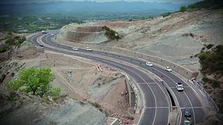
The Western Peripheral Expressway (WPE) or Kundli–Manesar–Palwal Expressway, is an operational 6-lane, 135.6 km (84.3 mi)-long Expressway in the Haryana state of India. Along with the Eastern Peripheral Expressway, the Western Peripheral Expressway is expected to divert more than 50,000 heavy vehicles away from Delhi, which will help to maintain good air quality in Delhi. Western Peripheral Expressway along with Eastern Peripheral Expressway completes the largest Ring Road around Delhi. There are 10 tolled entries and exits, from north to south - Kundli, Kharkhoda, Bahadurgarh, Badli, Fartukhnagar, Panchgaon, Manesar, Taoru, Sohna & Palwal. Toll rate notified in December 2018 is INR1.35 per km for cars, INR2.18 per km for light motor vehicles, INR4.98 per km for trucks and buses, and two wheelers are not permitted on the expressway.
National Highway 44 is a major north–south National Highway in India and is the longest in the country.

Old National Highway 2 or Old NH 2, was a major National Highway in India, that connected the states of Delhi, Haryana, Uttar Pradesh, Bihar, Jharkhand and West Bengal. It constitutes a major portion of the historical Grand Trunk Road along with old NH 91 and old NH 1 in India. The highway connects national capital Delhi with Kolkata as well as important cities such as Faridabad, Mathura, Agra, Kanpur, Allahabad, Varanasi, Dhanbad, Asansol, Durgapur and Bardhaman.

Expressways are the highest class of roads in India. As of June 2023, India has a total length of 4,219 km of expressways. These are controlled-access highways where entrance and exits are controlled by the use of cloverleaf or trumpet or grade separated interchanges that are incorporated into the design of the expressway and designed for maximum speed of 120 km/hr, whereas National highways are flyover access or controlled-access highway, where entrance and exit is through the side of the flyover, at each intersection of highway with road, flyovers are provided to bypass the city/town/village traffic and these highways are designed for speed of 100 km/hr. Some roads are not access-controlled expressways, but are still named as expressways, such as the Biju Expressway, these are actually state highways which are not declared by central government as an Expressway, hence not an Expressway or National Highway. Mumbai–Pune Expressway is the first 6-lane operational expressway in India started in 2002. Expressways follow standards set by Indian Roads Congress and Bureau of Indian Standards.
The Eastern Peripheral Expressway (EPE) or Kundli–Ghaziabad–Palwal Expressway is a 135 km (84 mi) long, 6-lane wide expressway passing through the states of Haryana and Uttar Pradesh in India. The expressway starts from the Western Peripheral Expressway at Kundli, Sonipat, passing through Baghpat, Ghaziabad and Noida districts in UP and Faridabad district in Haryana before rejoining the Western Peripheral Expressway near Dholagarh, Palwal. Eastern Peripheral Expressway along with Western Peripheral Expressway completes the largest Ring Road around Delhi. The Eastern Peripheral Expressway was declared as National Expressway 2 (NE-2) in March 2006.
The Faridabad–Noida–Ghaziabad Expressway or FNG Expressway is an under-construction 56 km long, 6-lane wide expressway in Delhi NCR region of India. It will connect Faridabad in Haryana with Noida and Ghaziabad in Uttar Pradesh.
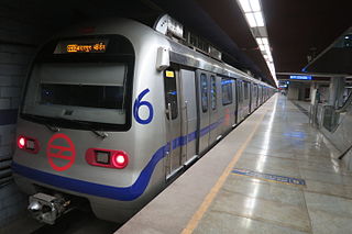
The Violet Line is a metro rail line of the Delhi Metro, a rapid transit system in Delhi, India. The line connects Kashmere Gate station in New Delhi with Raja Nahar Singh in Ballabhgarh via Faridabad. The line consists of 32 metro stations with a total length of 46.34 kilometres (28.79 mi).
Sarita Vihar is a posh residential colony situated in South East Delhi, India. It is near the Kalindi Kunj- Noida Toll bridge or GD Birla Marg-Road 13A which connects the district to Noida. It is believed that the site was primarily chosen as the construction site for the Games Village of the 1982 Asian Games, however on the insistence of the late Prime Minister Rajiv Gandhi, the plan was changed to convert it into an upscale residential housing locality. In 2013, it was awarded the "Greenest Colony in Delhi" tag by the then Chief Minister of Delhi, Ms. Sheila Dikshit, credited to the efforts of its RWA members who have aggressively worked towards improving the state of parks and green spots in the locality.
Northern Peripheral Road or NH 248-BB, commonly known as Dwarka Expressway is a 27.6 km (17.1 mi) long, under construction, 8-lane, elevated grade separated expressway connecting Dwarka in Delhi to Kherki Daula Toll Plaza, Gurgaon in Haryana. The expressway will take off from km 20 of NH 48 at Shiv Murti in Mahipalpur in Delhi and terminate at km 40 of NH 48 near Kherki Daula Toll Plaza in Gurgaon in Haryana. The NPR has been planned as an alternate road link between Delhi and Gurgaon, and is expected to ease the traffic situation on the Delhi-Gurgaon Expressway. The expressway was initially planned to be 18 km (11 mi) long and was expected to open by 2012 but land acquisition issues delayed the project.
Badarpur is a historic town in South East Delhi district in Delhi.

The Delhi–Panipat Regional Rapid Transit System is an approved, 103 km (64 mi) long, semi-high speed rail corridor connecting Delhi, Sonipat, and Panipat in the National Capital Region. It is one of the three RapidX corridors planned under Phase-1 of the Rapid Rail Transport System of the National Capital Region Transport Corporation (NCRTC). With maximum speed of 160 km/h and average speed of 120 km/h, commuters using the system will be able to cover the distance between Panipat and Delhi in 65 minutes. The project is expected to cost ₹ 21,627 crores.
The Delhi–Mumbai Expressway is a 1,350 km long, 8-lane wide under-construction access-controlled expressway connecting India's national capital New Delhi with its financial capital Mumbai. Foundation stone of the project was laid by union minister Nitin Gadkari in presence of Sushma Swaraj and Arun Jaitley on 8 March 2019. The total project value including the land acquisition cost is around ₹1,00,000 crores. An additional 31 km long spur will also be constructed by the NHAI from Noida International Airport in Jewar to Sector-65, Faridabad on this expressway.
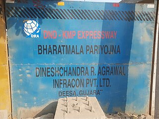
DND–Faridabad–KMP Expressway (NH-148NA) is an under-construction 59 km long, 6-lane wide access-controlled expressway in Delhi NCR, India. It will connect the junction of DND Flyway and Ring Road at Maharani Bagh in Delhi with KMP Expressway at Khalilpur, Nuh district in Haryana. Initially it was a separate expressway, but now it is a part of Delhi–Mumbai Expressway project. This expressway will have an additional 31 km long spur link from Sector-65, Faridabad bypass to Jewar Airport.

Madanpur Khadar is an urban village in South East district of Delhi. It is located on Delhi-UP Border and is an 800 years old village, named after Thakur Madan Singh Chauhan. The term Khadar is attached to the village’s name because it is situated on the banks of Yamuna river. It was declared as an urban village by the administrative authorities under Delhi Metropolitan Council in 1966.
Urban Extension Road-II or NH-344M is an upcoming 75.7 km long, 6 lanes & 4 lanes wide access-controlled expressway in Delhi NCR, India. It would start from National Highway 44 at Alipur then passes from Rohini, Mundka, Najafgarh, Dwarka and end at Delhi–Gurgaon Expressway on National Highway 48 near Mahipalpur. Its main route forms a semicircle on the western side of Delhi, additionally it has two side spurs - one from Bawana in Northwest Delhi to Sonipat in Bawana's North and second in west Delhi from between Tikri border & Najafgarh to NH9 Bahadurgarh south bypass. Delhi NCT has 4 concentric ring roads around it - namely Inner Ring Road; Outer Ring Road; third ring outside it formed by the combination of UER-II & Chilla-Okhla Expressway, and fourth ring formed by the combination of part of Dwarka Expressway & Gurugaon-Ghata Expressway, Gurgaon-Sohna Elevated Corridor Expressway, Sohna-Faridabad section of Delhi-Mumbai Expressway, Faridabad–Noida–Ghaziabad Expressway (FNG), Ghaziabad-Narela Expressway (planned) and Rai-Narela-Bahadurgarh-Gurgaon Expressway. Outside these ring roads, NCR region will have 3 Regional Circular Expressways and 3 Zonal Circular Expressways (ZCE).


