Black Creek (Toronto)

Last updated
Black Creek
Black Creek Toronto.jpg
Black Creek at Eglinton Avenue West
Toronto map.png
Red pog.svg
Location of the mouth of the creek in Toronto
Location
Country Canada
Province Ontario
Region Golden Horseshoe
Municipalities
Physical characteristics
Sourceretention basin
  location Vaughan, Regional Municipality of York
  coordinates 43°49′35″N79°33′34″W / 43.82639°N 79.55944°W / 43.82639; -79.55944 [1]
  elevation210 m (690 ft) [2]
Mouth Humber River
  location
Toronto
  coordinates
43°40′09″N79°30′41″W / 43.66917°N 79.51139°W / 43.66917; -79.51139 [3] Coordinates: 43°40′09″N79°30′41″W / 43.66917°N 79.51139°W / 43.66917; -79.51139 [3]
  elevation
89 m (292 ft) [2]
Basin size66 km2 (25 sq mi)

Black Creek is a river in the Golden Horseshoe region of Ontario, Canada. It flows from the city of Vaughan in the Regional Municipality of York to the Humber River in Toronto. [3] [1] [4] Black Creek is smaller than most of the waterways in the Greater Toronto Area.

Contents

Course

The creek begins in the Vellore neighbourhood of Vaughan at the outflow from a Retention basin just north-west of the intersection of Weston Road and Rutherford Road (Fossil Hill Pond) at an elevation of 210 metres (689 ft). [2] It flows southeast under Highway 400 at Langstaff Road and heads south along the side of the highway, before turning abruptly east near Pennsylvania Ave. and abruptly south again at Jane St. The creek continues south in the vicinity of Jane St., before passing under Highway 7, Highway 407 and Steeles to reach Toronto at the eponymous Black Creek Pioneer Village open-air historic museum. It passes the main York University campus and heads into the Downsview area in a forested ravine. It continues south in a natural setting, passing in short culverts underneath Shoreham Drive, Finch Ave. West, Grandravine Drive and Sheppard Ave. West, before turning to the west and arriving back at Jane St. south of Sheppard Ave. After crossing under Jane St., the creek passes through Oakdale Golf and Country Club and Chalkfarm Park. At the southeast end of Chalkfarm Park, near Jane St. and Wilson Ave., the creek enters a concrete channel, continuing roughly south along Jane St. under Highway 401. [3] [1] [4]

From Jane St. and Highway 401, the creek continues south in a concrete channel until Queens Drive. The creek is then mostly in a natural state as it flows through the Upwood and Westview Greenbelts, Trethewey Park East and Keelesdale Park, with segments of culvert where it passes under city streets. Beginning near Jane St. and Highway 401, the creek valley also provides the routing for the eponymous Black Creek Drive, which follows the creek south to past Eglinton Avenue West to Weston Road in the neighbourhood of Mount Dennis. South of Weston Road, Black Creek runs in a man-made concrete channel in the median of Humber Boulevard, continuing to the south of Alliance Avenue and through Lambton Golf Club, and reaches its mouth as a left tributary of the Humber River near Scarlett Road and Dundas Street West at an elevation of 89 metres (292 ft). [3] [1] [4] [2]

The environmental health of Black Creek and its watershed has been an important issue in Toronto and the GTA for decades. The creek can be split into 3 general zones: source-Highway 407, Highway 407-Weston Road, and Weston Road-Humber River. From its source in Vaughan to approximately Highway 407, Black Creek runs primarily in drainage ditches through the sprawling Vaughan Business Park, an industrial area bounded by Rutherford Road to the north, CN MacMillan Yard to the east, Highway 7 to the south and Highway 400 to the west. Within the business park, it receives water from several other storm water retention ponds. Between Highway 407 and Weston Road, the creek is situated in a more natural, forested environment, albeit sharing the creek valley with Black Creek Drive. South of Weston Road continuing to the mouth of Black Creek at the Humber River, almost the entire length of the creek consists of concrete channels running through parkland and along residential streets. Black Creek is susceptible to chemical runoff from the 2 golf courses the creek passes within the city of Toronto as well as the industrial areas upstream in Vaughan. In addition, the highly channelized nature of the creek means that during times of heavy rain or snowmelt, the creek's lower reaches within Toronto as well as parts of the Humber River downstream become highly susceptible to flooding. [4] [1] [3] The channelized portions of the creek south of Weston Road have garnered the nickname "Toronto's LA River", in reference to the barren, concrete channel carrying the LA River through Los Angeles, California.

Downsview Park

An artificial man made storm water pond, Walkway Pond, flows out through an underground channel to Donwnsview Dells to Humber River via Black Creek. [5]

Lavender Creek

Lavender Creek's source is near Dufferin Street and Eglinton Avenue West. It has long been buried from Fairbank Park to east of Weston Road and north-east of the Gunns Road intersection. It travels underground under Weston Road west through a culvert before re-emerging. From north of Gunns Road, the watercourse continues west to Symes Road and continues north, behind the homes on Hilldale Road to meet Black Creek south-west of Humber Boulevard and Alliance Avenue. [6]

August 2005 flooding

On August 19, 2005, Black Creek was the site of heavy flooding as a result of extremely heavy rains that afternoon. Its overflow destroyed a culvert on Finch Avenue.

Communities

Attractions and protected areas

See also

Related Research Articles

Humber River (Ontario) River in Canada

The Humber River is a river in Southern Ontario, Canada. It is in the Great Lakes Basin, is a tributary of Lake Ontario and is one of two major rivers on either side of the city of Toronto, the other being the Don River to the east. It was designated a Canadian Heritage River on September 24, 1999.

Humber River—Black Creek Federal electoral district in Ontario, Canada

Humber River—Black Creek is a federal electoral district in Toronto, Ontario, Canada, that has been represented in the House of Commons of Canada from 1867 to 1904 and since 1917. Prior to the 2015 election, the riding was known as York West. The former name reflects the riding is in the former Township of York which is within the City of Toronto.

Rouge River (Ontario) River in Ontario, Canada

The Rouge River is a river in Markham, Pickering, Richmond Hill and Toronto in the Greater Toronto Area of Ontario, Canada. The river flows from the Oak Ridges Moraine to Lake Ontario at the eastern border of Toronto, and is the location of Rouge Park, the only national park in Canada within a municipality. At its southern end, the Rouge River is the boundary between Toronto and southwestern Pickering in the Regional Municipality of Durham.

Downsview Neighbourhood in Toronto, Ontario, Canada

Downsview is a neighbourhood in the north end of Toronto, Ontario, Canada, located in the district of North York. The area takes its name from the Downs View farm established around 1842 near the present-day intersection of Keele Street and Wilson Avenue. It now extends beyond the intersection of Sheppard Avenue and Dufferin Street, though it is popularly seen as including the areas to the north right up to the Toronto city limit at Steeles Avenue. The area includes several large post-World War II subdivisions. Within the area is Downsview Airport, the former site of Canadian Forces Base Downsview, which has since been largely converted following the end of the Cold War into an urban park known as Downsview Park. The airport is still used as a manufacturing and testing facility for Bombardier Aerospace.

York Centre Federal electoral district in Ontario, Canada

York Centre is a federal electoral district in Ontario, Canada, that has been represented in the House of Commons of Canada from 1904 to 1917 and since 1953.

Finch Avenue

Finch Avenue is an arterial thoroughfare that travels east–west in Toronto, Ontario, Canada. The road continues west into the Regional Municipality of Peel as Regional Road 2 and east into the Regional Municipality of Durham as Regional Road 37.

Woodbridge, Ontario Suburban district in York, Ontario, Canada

Woodbridge is a large suburban community in Vaughan, Ontario, Canada, along the city's border with Toronto. Situated west of Highway 400 and east of Highway 50, north of Steeles Avenue, and generally south of Major Mackenzie Drive West. It was once an independent town before being amalgamated with nearby communities to form the city in 1971. Its traditional downtown core is the Woodbridge Avenue stretch between Islington Avenue and Kipling Avenue north of Highway 407.

Sheppard Avenue

Sheppard Avenue is an east–west principal arterial road in Toronto, Ontario, Canada. The street has two distinct branches near its eastern end, with the original route being a collector road leading to Pickering via a turnoff, and the main route following a later-built roadway which runs south to Kingston Road. To avoid name duplication, the Toronto portion of the northern branch was renamed Twyn Rivers Drive. The section of the street entirely in Toronto is (34.2 km) in length, while the Pickering section and Twyn Rivers Dr. is (5.4 km) long.

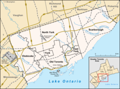
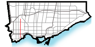
Black Creek Drive is a four lane north-south arterial road in the Canadian city of Toronto, which connects Weston Road and Humber Boulevard with Highway 401 via Highway 400, the latter of which it forms a southerly extension. Black Creek Drive officially transitions into Highway 400 at the Maple Leaf Drive overpass, southeast of Jane Street. The roadway is named after the Black Creek ravine, which it parallels for most of its route. It features a maximum speed limit of 70 km/h (43 mph). As a municipal road, it is patrolled by the Toronto Police Service.

Keele Street

Keele Street is a north–south road in Toronto, Vaughan and King in Ontario, Canada. It stretches 47 km, running from Bloor Street in Toronto to the Holland Marsh. South of Bloor Street, the roadway is today known as Parkside Drive, but was originally part of Keele Street. It was renamed in 1921 by the City of Toronto.

Humber Heights-Westmount Neighbourhood in Toronto, Ontario, Canada

Humber Heights-Westmount, also known as Humbervale, is a neighbourhood in Etobicoke, Toronto, Ontario. The neighbourhood is bounded by the west bank of the Humber River, west to Royal York Road and south to Eglinton Avenue West. The Humber Creek divides the area into the northern 'Humber Heights' and the southern 'Westmount' centred along Scarlett Road and La Rose Avenue.

Rockcliffe–Smythe Neighbourhood in Toronto, Ontario, Canada

Rockcliffe–Smythe is a neighbourhood in Toronto, Ontario, Canada. It was part of the former City of York before the amalgamation of Toronto in 1998. It is in Ward 5 in the City of Toronto.

Lambton, Toronto Neighbourhood in Toronto, Ontario, Canada

Lambton is a neighbourhood in the city of Toronto, Ontario, Canada. It is situated on the east bank of the Humber River north and south of Dundas Street West. It is bounded on the north by Black Creek, on the east by Jane Street and on the south by St. Mark's Road. The area west of Gooch Road is also known as "Warren Park", the name of the housing sub-division built in the 1950s. The portion south of Dundas Street is within the 'Lambton Baby Point' neighbourhood as defined by the City of Toronto.

Highland Creek (Toronto)

Highland Creek is a river in the Scarborough district of Toronto, Ontario, emptying into Lake Ontario at the eastern end of the Scarborough Bluffs. It is home to several species of fish including trout, carp, bass and salmon. It is a meandering river which, like most rivers in Toronto, travels through a glacial ravine formed after the last Ice Age. The Highland Creek watershed, including tributaries, is almost entirely contained within Scarborough.

Royal York Road Thoroughfare in Toronto, Ontario

Royal York Road, historically known as Church Street or New Church Street, is a north-south arterial road in Toronto, Ontario, Canada. It is a concession road, 5 concessions (10 km) west of Yonge Street, and runs through many residential neighbourhoods, most notably Mimico and the Kingsway. It is classified as a "minor arterial" road by the city of Toronto.

Humber River—Black Creek (provincial electoral district)

Humber River—Black Creek is a provincial electoral district in Ontario, Canada, that has been represented in the Legislative Assembly of Ontario since 1999. Prior to the 2018 election, the riding was known as York West.

References

  1. 1 2 3 4 5 "Toporama (on-line map and search)". Atlas of Canada . Natural Resources Canada. Retrieved 2010-08-29.
  2. 1 2 3 4 "Google Earth" . Retrieved 2020-08-08.
  3. 1 2 3 4 5 6 "Black Creek". Geographical Names Data Base . Natural Resources Canada . Retrieved 2020-08-07.
  4. 1 2 3 4 "Ontario Geonames GIS (on-line map and search)". Ontario Ministry of Natural Resources and Forestry. 2014. Retrieved 2020-08-07.
  5. "Downsview Park in Toronto is a massive urban park around an artificial lake".
  6. Micallef, Shawn (2015-05-27). "Searching for the buried Lavender Creek". Toronto Star. Retrieved 2018-06-11.